
Unseasonably strong hurricane-force low approaches Aleutians and Bering Sea, Alaska
A 958 hPa hurricane-force extratropical low is approaching the Aleutian Islands and Bering Sea on April 26, 2026. NOAA’s Ocean Prediction Center issued a Hurricane Force Wind Warning, with winds of 93-120 km/h (58–75 mph) and seas of 7-10 m (23-33 feet) in the southern semicircle.

Image credit: JMA/Himawari-9, NOAA/GOES-West, Zoom Earth, The Watchers. Acquired at 01:40 UTC on April 26, 2026
The Ocean Prediction Center (OPC) forecasts the low to become nearly stationary within 24 hours, keeping dangerous marine conditions across waters near the western Aleutians.
In the southern semicircle, winds were forecast at 93-120 km/h (58-75 mph) within 333 km (207 miles) of the center, while seas were forecast at 7-10 m (23-33 feet). Elsewhere within 444 km (276 miles) of the low, OPC forecast winds of 74-93 km/h (46-58 mph) and seas of 5-9 m (16-30 feet).
NWS Anchorage described the system as an unseasonably strong hurricane-force low approaching Adak and Atka. A High Wind Warning remained in effect for both communities, with gusts up to 130 km/h (80 mph), while Nikolski and Unalaska were under a Wind Advisory for gusts of 95-120 km/h (60-75 mph).
Satellite imagery showed rapid organization as the low approached Adak from the south-southwest, with dense cold cloud tops spiraling from the storm center and a developing sting-jet feature south of the low, according to NWS Anchorage. The strongest winds were forecast over marine waters south of Adak and Atka as the system moved from the Pacific side of the Aleutians into the Bering Sea.
The frontal zone tied to the low was moving north along the eastern Aleutians, bringing gale- to low-end storm-force winds and a band of rain and snow. NWS Anchorage forecast southeast gusts up to 100 km/h (60 mph) across the Pribilof Islands, with coastal parts of Southwest Alaska forecast to see gusts of 65-80 km/h (40-50 mph) as the front moved inland.
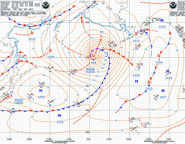
OPC forecasts the low to remain over the central Bering Sea, north of the Aleutians, through 00:00 UTC on April 27 while holding at 958 hPa. Winds of 65-93 km/h (40-58 mph) and seas of 5-9 m (16-30 feet) were forecast southeast of the low center. By 00:00 UTC on April 28, OPC forecast the system to weaken to 972 hPa, with winds of 45-75 km/h (30-45 mph) and seas of 4-7 m (13-23 feet) across nearby waters.
NWS Anchorage forecast the low to stall west of the Pribilof Islands between Monday and Tuesday as it became vertically stacked and weakened in place. Winds across the Aleutians and Bering Sea were forecast to decrease from storm-force to gale-force Sunday night, then drop below gale-force by Tuesday afternoon.
References:
1 Southcentral and Southwest Alaska Forecast Discussion – NWS/Anchorage – April 25, 2026
I'm a dedicated researcher, journalist, and editor at The Watchers. With over 20 years of experience in the media industry, I specialize in hard science news, focusing on extreme weather, seismic and volcanic activity, space weather, and astronomy, including near-Earth objects and planetary defense strategies. You can reach me at teo /at/ watchers.news.
Commenting rules and guidelines
We value the thoughts and opinions of our readers and welcome healthy discussions on our website. In order to maintain a respectful and positive community, we ask that all commenters follow these rules.