
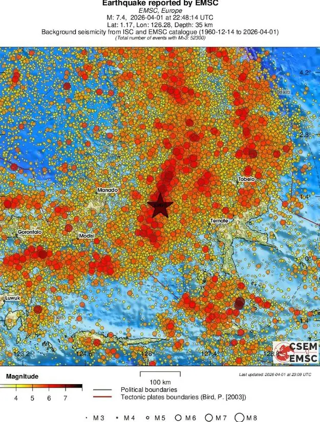
Major M7.4 earthquake hits Molucca Sea, Indonesia, tsunami waves observed
A major earthquake registered by the USGS as M7.4 hit the Molucca Sea, Indonesia, at 22:48 UTC on April 1, 2026. The agency is reporting a depth of 35 km (22 miles). EMSC is reporting the same magnitude and depth. According to the Pacific Tsunami Warning Center (PTWC), tsunami waves up to 0.65 m (2.1 feet) were observed at Kema, Sulawesi.
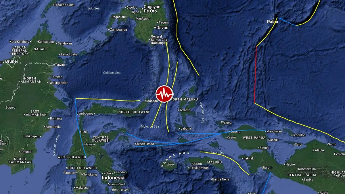
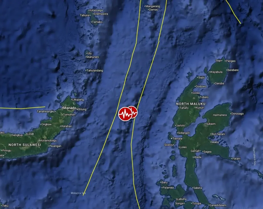
Epicenter of M7.4 earthquake in Molucca Sea, Indonesia on April 1, 2026. Credit: TW/SAM, Google
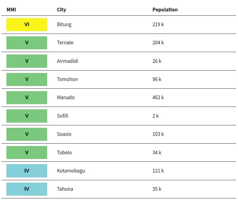
The epicenter was located 126 km (78 miles) WNW of Ternate (population 205 001), 135 km (84 miles) ESE of Bitung (population 225 134), 147 km (91 miles) WNW of Sofifi (population 36 197), 155 km (97 miles) E of Tondano (population 33 317), and 166 km (103 miles) ESE of Manado (population 451 916), Indonesia.
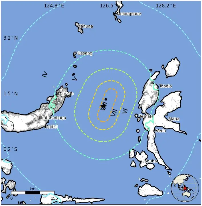
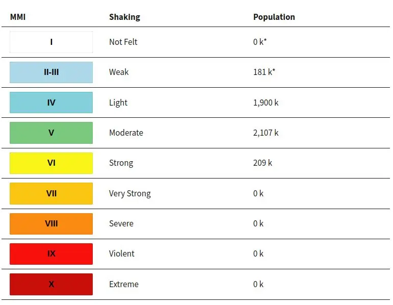
209 000 people are estimated to have felt strong shaking, 2 107 000 moderate, and 1 900 000 light, according to the USGS PAGER.
Pacific Tsunami Warning Center (PTWC) said hazardous tsunami waves were possible for coasts within 1 000 km (620 miles) of the epicenter, including Indonesia, the Philippines and Malaysia.
The threat was later refined to waves of 0.3 to 1 m (1 to 3 feet) above tide level for some coasts of Indonesia and less than 0.3 m (1 foot) for parts of the wider region.
Tsunami waves were observed, with a maximum height of 0.65 m (2.1 feet) at Kema, Sulawesi, while smaller waves of 0.15 m (0.5 feet) were recorded at Beo, 0.13 m (0.4 feet) at Talengen, and 0.05 m (0.2 feet) at Davao, Philippines.
In its final message, issued at 01:11 UTC on April 2, PTWC said the tsunami threat had largely passed, although minor sea-level fluctuations of up to 0.3 m (1 foot) above and below normal tide could continue for the next few hours.
The USGS issued a Green alert for shaking-related fatalities and economic losses. There is a low likelihood of casualties and damage.
Overall, the population in this region resides in structures that are vulnerable to earthquake shaking, though resistant structures exist. The predominant vulnerable building types are unreinforced brick with a concrete floor and precast concrete frame with wall construction.
Recent earthquakes in this area have caused secondary hazards such as tsunamis that might have contributed to losses.
Strong aftershocks followed the quake, with the strongest registered as M6.2 at 03:23 UTC on April 2.
According to the USGS, the quake occurred on or near the interface between the subducted Halmahera slab and the overlying Sunda plate, in the complex plate boundary region of eastern Indonesia, about 300 km (186 miles) west of the major plate boundary between the Sunda and Pacific plates.
Fault mechanism solutions indicate reverse faulting on a moderately dipping structure toward either the northwest or southeast, consistent with the general trend of earthquakes in the region.
Although the earthquake occurred near the boundary between the Halmahera slab and the Sunda plate, it was not a traditional plate interface event like those seen in other subduction zones, because the Halmahera slab is fully subducted and has no surface expression. Slip on a fault aligned with either nodal plane is therefore consistent with the tectonic setting of this event.
Tectonics in eastern Indonesia are extremely complex and are dominated by mostly convergent interactions among the Pacific, Australia, Philippine Sea, and Sunda plates, with some authors identifying the nearest edge of the Pacific plate here as a separate tectonic block called the Caroline plate.
The edges of the Sunda and Australia plates are also often subdivided into smaller tectonic blocks, including the Molucca Sea and Bird’s Head microplates immediately south and east of the April 2026 earthquake, respectively.
In this context, the April 2026 event most closely aligns with the boundary between the broader Sunda plate and the Bird’s Head microplate. At depth beneath this earthquake and the Molucca Sea in general, the inverted U-shaped Halmahera plate, which has no surface expression, also plays a role in regional tectonics. At the location of the April 1 earthquake, the Sunda and Philippine Sea plates are converging in an east-west direction at a rate of approximately 100 mm (3.9 inches) per year.
While earthquakes of this size are often plotted as points on maps, they are more accurately described as slip over a broader fault area. Reverse-faulting events of the size of the April 1, 2026, earthquake typically rupture an area about 70 km by 35 km (43.5 by 21.7 miles) in length and width.
This part of the Molucca Sea frequently hosts moderate to large earthquakes. Over the past 50 years, nine other M7+ earthquakes have occurred within 250 km (155 miles) of the April 1, 2026, event.
This includes a M7.5 earthquake in January 2007 located just 13 km (8.1 miles) southwest of this event. Despite the large number of earthquakes in the region, few have been damaging because of their offshore setting, although the 2007 event resulted in three shaking-related fatalities and minor damage on the nearby island of Sulawesi.
Updates
08:42 UTC, April 2
Indonesia’s Search and Rescue Agency confirmed one fatality, a 70-year-old woman who died in a building collapse in the Minahasa district, North Sulawesi, as well as at least one injury.
Initial assessments revealed light to severe structural damage, including a church and two houses in Ternate, with additional reports of affected buildings in nearby Manado and Bitung.
Residents evacuated amid strong shaking, and authorities dispatched teams to inspect structures and remote villages. The Associated Press noted that at least three people were hospitalized in Ternate
Estimated population exposure to earthquake shaking
Selected cities exposed
Regional seismicity
References:
1 M7.4 earthquake Molucca Sea, Indonesia – USGS – April 1, 2026
2 M7.4 earthquake Molucca Sea – EMSC – April 1, 2026
I'm a dedicated researcher, journalist, and editor at The Watchers. With over 20 years of experience in the media industry, I specialize in hard science news, focusing on extreme weather, seismic and volcanic activity, space weather, and astronomy, including near-Earth objects and planetary defense strategies. You can reach me at teo /at/ watchers.news.
Warning From God To avoid death by these punishments from God natural disasters strong earthquakes more mag 7 earthquake tsunami volcano in Indonesia in Turkey in US in Japan in Russia in Muslim countries and non-Muslim countries Muslims to apply Quran 100% and non-Muslims convert to Islam immediately and to avoid hell if the end of the world April 2026.