
Earthquake swarm near Tonopah, Nevada
A swarm of small earthquakes has been shaking the desert northeast of Tonopah, Nevada, since late February 2026, with nearly a hundred shallow events recorded by the U.S. Geological Survey through 17:00 UTC on March 4.

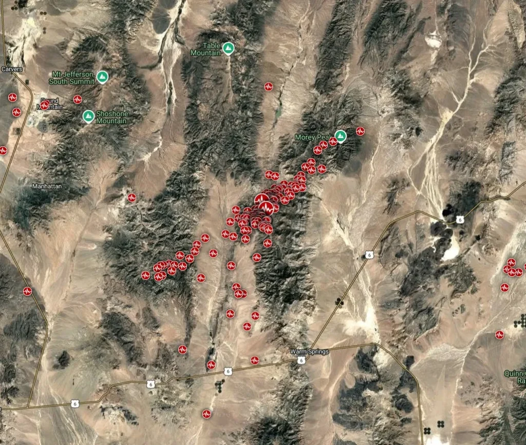
Earthquakes detected northeast of Tonopah, Nevada from February 4 to March 4, 2026. Credit: TW/SAM, Google. Data source: USGS
A swarm of small to moderate earthquakes continues in central Nevada, about 75 to 90 km (47 to 56 miles) northeast of Tonopah in Nye County. The sequence began in late February and remains active through March 4.
According to the U.S. Geological Survey (USGS) and the Nevada Seismological Laboratory, nearly 100 earthquakes have been recorded through 17:00 UTC on March 4, most between magnitudes 1.5 and 3.0, with a few reaching above M3.5. The largest event so far was M4.3 at 16:37 UTC on March 1, at a depth of 11 km (7 miles).
Instrumental records show the earthquakes cluster along a short, unmapped fault segment within the Basin and Range Province, a region of active crustal extension spanning much of Nevada.
Scientists describe the pattern as a tectonic swarm, a sequence of many similar-sized quakes without a single mainshock. Earthquake swarms release local strain gradually and are common in western Nevada, which ranks among the most seismically active parts of the continental United States.
The USGS ShakeMap for the M4.3 event indicates light shaking, intensity III to IV, felt across Tonopah and nearby desert communities. No structural damage, injuries, or service interruptions have been reported. Regional networks continue to detect low-magnitude aftershocks, but at a slowly declining rate.
Local seismologists emphasize that the swarm’s characteristics are consistent with natural fault movement. They note that similar clusters have occurred repeatedly in the state, including the Monte Cristo Range M6.5 sequence of 2020 and the Hawthorne swarm of 2011. In each case, the events were confined to shallow normal faults responding to ongoing Basin and Range extension.
Speculation about links to nearby military installations resurfaced on social media after the initial M4.3 quake, echoing past rumors of underground testing. Both the USGS and independent academic seismologists have stated that the seismic waveforms, depths, and geographic pattern confirm a natural origin unrelated to military or industrial activity.
The area lies roughly 80 km (50 miles) from the Tonopah Test Range, but the quake depths and distribution rule out human sources.
References:
1 M4.3 earthquake NE of Tonopah, Nevada – USGS – March 1, 2026
I'm a dedicated researcher, journalist, and editor at The Watchers. With over 20 years of experience in the media industry, I specialize in hard science news, focusing on extreme weather, seismic and volcanic activity, space weather, and astronomy, including near-Earth objects and planetary defense strategies. You can reach me at teo /at/ watchers.news.
Commenting rules and guidelines
We value the thoughts and opinions of our readers and welcome healthy discussions on our website. In order to maintain a respectful and positive community, we ask that all commenters follow these rules.