
Storm Nils kills 1 in France, triggers rare Red Avalanche Alert in Savoie as 850 000 lose power
At least one person was reported dead as Storm Nils brought damaging winds to France late on February 11, 2026, with gusts exceeding 180 km/h (112 mph) recorded in parts of the country. More than 900 000 customers were left without power as authorities issued red and orange alerts across multiple departments, while Savoie was placed under a rare red avalanche alert on February 12 after multiple avalanches were reported.
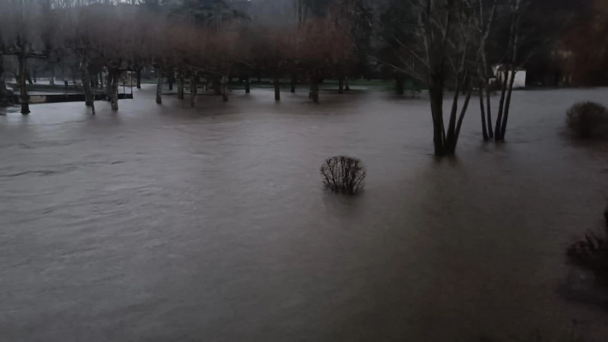
Flooding in France caused by Storm Nils on February 12, 2026. Credit: Florence Joubert
At least one person has been reported dead since Storm Nils began impacting France on February 11, bringing destructive winds of over 180 km/h (112 mph) to some areas.
The strongest gust of 185 km/h (115 mph) was recorded at Cagnano. Gusts reached 180 km/h (112 mph) in Caixas, located in the Aspres area, while the Perpignan–Rivesaltes station recorded a gust of 149 km/h (93 mph) on February 12, according to Meteo France.
A lorry driver died after a tree branch fell on his vehicle near Dax in southwest France. The incident occurred overnight on D824 at Mées near Dax in the Landes department.
A man in Bayonne suffered minor injuries after a tree fell on his car, while in Charente, 66 residents of a care home in La Rochefoucauld were evacuated as a precaution due to its location near a river.
Over 900 000 customers experienced power outages on the morning of February 12. Most of the outages were concentrated around the Nouvelle-Aquitaine and Occitanie areas, according to grid operator Enedis. The company deployed more than 400 workers to restore power.
The A9 motorway between Leucate and Perpignan was temporarily closed after multiple heavy vehicles overturned due to strong crosswinds.
Authorities put restrictions on vehicles weighing over 7.5 tons across affected departments, with traffic being restricted to single lanes on multiple routes. Schools closed in Aude and Pyrénées-Orientales due to the severe weather.
Nils is the third strong winter storm of the season over France after the passage of Benjamin (October 2025) and Goretti (January 2026).
“It is a remarkable westerly storm over the Aude and the Pyrénées-Orientales. The wind values accompanying Nils are the highest since the reference storm Klaus (2009) when the wind reached unprecedented values in the South-West and Roussillon (159 km/h (99 mph) in Narbonne, 184 km/h (114 mph) in Perpignan),” said Meteo France.
Three departments were put under Red Alert, while 27 were under an Orange Alert through February 12. “It is the first time that a Red Alert level has been activated simultaneously for three parameters: wind, flooding, and avalanches,” said Meteo France.
Vigicrues, the national flood monitoring service, warned the Garonne River could overflow, with potential flooding comparable to January 2022 levels. The Dordogne prefecture advised residents to remain indoors and postpone nonessential travel.
Among the departments under Red Alert are Gironde and Lot-et-Garonne, both of which are under the alert for the risk of floods.
Meanwhile, Savoie is under a rare Red Alert for avalanches, which will be downgraded to an Orange Alert on February 13. This is only the third time since the system was created 25 years ago that this highest level of alert has been activated, and the second time in the Alps.
Previous Red Avalanche Alerts were issued on January 8 and 9, 2018, in the Alps (Haute-Maurienne), and on January 15 and 16, 2013, in the Pyrenees.
Multiple avalanches have been recorded in the area since February 12, with some reaching valley floors at elevations of 1 100–1 400 m (3 600–4 600 feet). More intense snowfall is redeveloping late this afternoon, with the snow line lowering to around 1 200 m (3 900 feet).
In the Beaufortain, Vanoise, and Haute-Maurienne massifs, significant avalanche activity is also expected through February 12. Numerous large avalanches, increasing in size as snowfall continues, are likely.
Another surge in avalanche activity is expected later in the afternoon and evening as snowfall intensifies again, after a temporary lull around midday.
Avalanches may reach roads and mountain infrastructure, generally above 1,800 m. However, exceptionally large avalanches could descend lower into some usual valley bottoms, down to elevations of approximately 1 000–1 200 m (3 600–3 900 feet).
Fresh snowfall totals across these massifs could reach or even exceed 1 meter. However, the primary aggravating factor is the presence of a particularly unstable pre-existing snowpack in some areas, which significantly increases the risk of very large avalanches reaching valley floors.

I am an Assistant Editor and Severe Weather & Science Journalist at The Watchers, specializing in real-time severe weather coverage, geophysical event reporting, and research-driven scientific analysis. You can reach me at rishav(at)watchers(.)news.

I’m a science journalist and researcher at The Watchers, contributing to the Epicenter edition, where I cover peer-reviewed scientific research and emerging discoveries across Earth and space sciences. With a background in astronomy and a passion for environmental science, I’ve worked in shark and coral conservation in Fiji, conducting reef and shark-behavior research, contributing to mangrove restoration, and earning PADI Open Water and Coral Reef Certifications. I bring a blend of scientific rigor and storytelling to illuminate the discoveries shaping our planet and beyond.
Commenting rules and guidelines
We value the thoughts and opinions of our readers and welcome healthy discussions on our website. In order to maintain a respectful and positive community, we ask that all commenters follow these rules.