
Two atmospheric rivers forecast to bring heavy rain to the Pacific Northwest through early November
Two atmospheric rivers are forecast to affect the Pacific Northwest between October 28 and November 2, 2025, bringing periods of heavy rainfall to western Washington and northern Oregon. The first system is expected to reach AR1 strength, while the second could intensify to AR3 or AR4 as it moves inland later in the week. Hydrologic models indicate notable river rises but no significant flooding at this time.
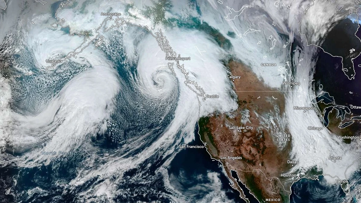
Satellite image of two atmospheric rivers approaching Canada and United States, acquired at 21:10 UTC on October 28, 2025. Credit: NOAA/GOES-East, Zoom Earth, The Watchers
Two atmospheric rivers are expected to bring consecutive rounds of rain to the region from Tuesday, October 28, through Sunday, November 2, according to the Center for Western Weather and Water Extremes (CW3E) and the U.S. National Weather Service (NWS).
The first system, now reaching the coast, is classified as a weak AR1 on the CW3E scale and is forecast to persist through early Wednesday, October 29, producing moderate rainfall of 25–50 mm (1–2 inches) along coastal Oregon and Washington and into the Cascades.

A stronger system follows from Friday, October 31, through Sunday, November 2, with a deep moisture plume extending from the central Pacific. Ensemble guidance from the Global Ensemble Forecast System (GEFS) and the European Centre for Medium-Range Weather Forecasts (ECMWF) shows high confidence, with more than 90% of members predicting integrated vapor transport (IVT) values above 250 kg m⁻¹ s⁻¹.
The CW3E classification, which ranks atmospheric rivers from 1 (weak) to 5 (exceptional) based on moisture intensity and duration, suggests this second event could reach AR3 to AR4 strength along the Washington and northern Oregon coastlines. Some ensemble members indicate brief AR5-level conditions along the southwest Washington coastal sector.

Forecast differences between global models remain minor but consistent. ECMWF simulations depict a more concentrated IVT core, roughly 200 kg m⁻¹ s⁻¹ stronger than GFS at landfall time, suggesting a more intense moisture plume and locally higher precipitation potential.

The Weather Prediction Center (WPC) forecasts total rainfall of 50–100 mm (2–4 inches) over the Olympic Peninsula and Washington Cascades through 17:00 PT on Friday, November 3. Its Day 4–5 Excessive Rainfall Outlook places a Marginal Risk, the first level on the four-tier scale, across parts of western Washington and Oregon.

Snow levels are expected to remain high for most of the event, with mainly rain below 2 740 m (9 000 feet) on October 31, dropping to near 1 830 m (6 000 feet) late November 1. Snow accumulation is likely to remain confined to the highest elevations of the Washington Cascades.
The Northwest River Forecast Center expects notable river rises during the second system, particularly in western Washington basins such as the Skokomish, Snoqualmie, and Cowlitz. Several gauges are forecast to approach Action Stage, though widespread flooding is not anticipated based on current precipitation and snowmelt projections.
Localized impacts may include minor roadway flooding and ponding of water on saturated soils in low-lying areas, especially near the Olympic Peninsula and the southwest slopes of the Cascades.
References:
1 Two Atmospheric Rivers to Bring Precipitation to the Pacific Northwest – CW3E – October 28, 2025
I'm a dedicated researcher, journalist, and editor at The Watchers. With over 20 years of experience in the media industry, I specialize in hard science news, focusing on extreme weather, seismic and volcanic activity, space weather, and astronomy, including near-Earth objects and planetary defense strategies. You can reach me at teo /at/ watchers.news.
Commenting rules and guidelines
We value the thoughts and opinions of our readers and welcome healthy discussions on our website. In order to maintain a respectful and positive community, we ask that all commenters follow these rules.