
Tropical Storm Fernand forms southeast of Bermuda
Tropical Storm Fernand formed on August 23, 2025, southeast of Bermuda as the sixth named storm of the 2025 Atlantic hurricane season. The system is currently moving north-northeast, with weakening forecast in the coming days.

Satellite image of Tropical Storm Fernand as of 21:20 UTC on August 23, 2025. Credit NOAA/GOES-East, RAMMB/CIRA, The Watchers
Tropical Storm Fernand formed in the central Atlantic Ocean at 21:00 UTC on August 23, becoming the sixth named storm of the 2025 Atlantic hurricane season.
The system originated from a well-defined low previously designated as AL90, consolidating into a tropical storm approximately 655 km (405 miles) south-southeast of Bermuda.
At 03:00 UTC on August 24, the center of Tropical Storm Fernand was located roughly 515 km (320 miles) southeast of Bermuda. The system had maximum sustained winds near the center of 65 km/h (40 mph) with higher gusts. Minimum central pressure was estimated at 1 010 hPa.
The storm was moving north-northeast at 26 km/h (16 mph), with tropical storm force winds extending up to 169 km (105 miles) outward from the center.
Fernand is is forecat to remain over open waters throughout its lifespan. It is expected to strengthen gradually over the next 48 hours while moving over warm sea surface temperatures and low vertical wind shear.
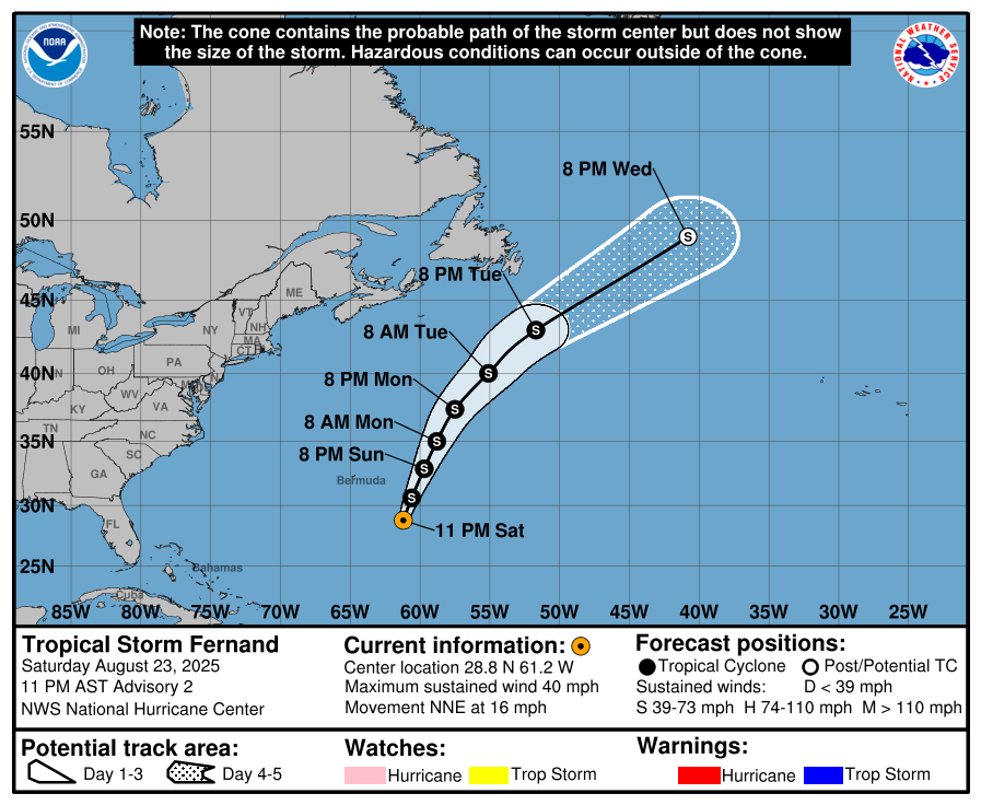
Peak winds may reach near hurricane strength by August 25, though the official forecast keeps it just below hurricane intensity. The storm is expected to begin weakening by August 26.
Fernand is expected to accelerate north-northeastward over the coming days, eventually transitioning into a post-tropical system by August 27 as it encounters cooler waters and increasing shear.

I am an Assistant Editor and Severe Weather & Science Journalist at The Watchers, specializing in real-time severe weather coverage, geophysical event reporting, and research-driven scientific analysis. You can reach me at rishav(at)watchers(.)news.
Commenting rules and guidelines
We value the thoughts and opinions of our readers and welcome healthy discussions on our website. In order to maintain a respectful and positive community, we ask that all commenters follow these rules.