
North Carolina highway closed following Hurricane Erin’s closest approach to U.S. Coast
Hurricane Erin made its closest approach to the U.S. coast overnight on August 19–20, 2025, closing part of North Carolina Highway 12 and prompting evacuations in coastal counties. Over 70 rip current rescues were reported along North Carolina beaches as the system brought storm surge, coastal flooding, and overwash to the Outer Banks.

Satellite image of Hurricane Erin as of 10:20 UTC on August 21, 2025. Credit GOES-19, RAMMB/CIRA, The Watchers
Hurricane Erin made its closest approach to the U.S. coast overnight on August 19–20, causing a coastal highway closure and prompting dozens of rip current rescues in North Carolina.
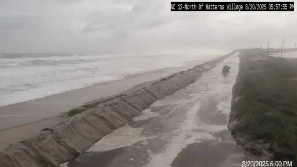
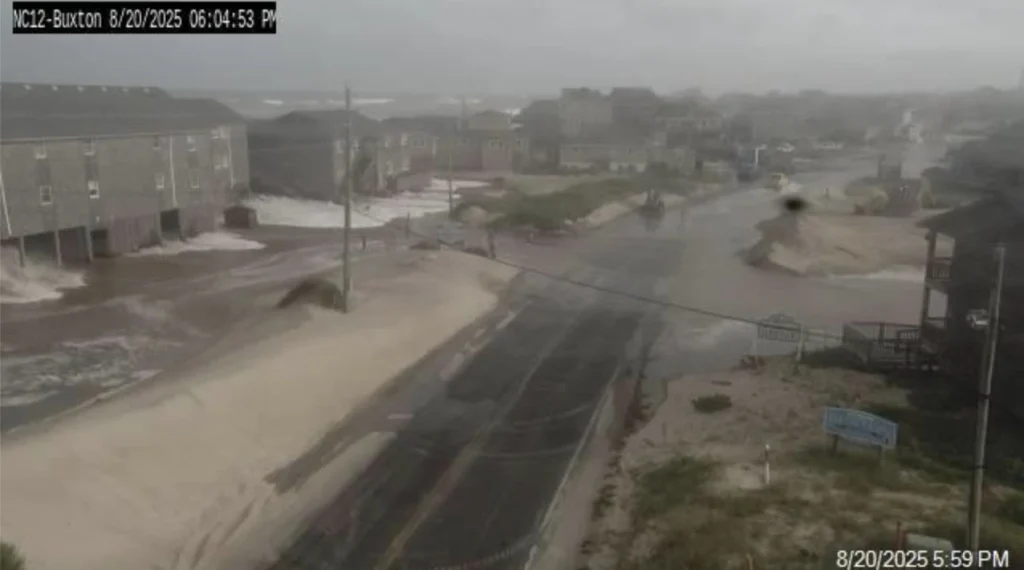
A 80.5 km (50 miles) stretch of North Carolina Highway 12 was closed from Oregon Inlet to Hatteras Village on August 20 due to storm surge and overwash as Erin brought strong waves to the coast.
Officials in three coastal counties in North Carolina issued mandatory evacuation orders, and the state’s governor declared a state of emergency due to concerns that some infrastructure could be compromised.
Erin has caused seawater levels to rise near the northern Outer Banks, with wave heights steadily increasing offshore from Duck, North Carolina.


A wave buoy 3.2 km (2 miles) off the coast recorded waves increasing from 1.5–1.8 m (5–6 feet) on the afternoon of August 20 to 2.1–2.4 m (7–8 feet) early on August 21.
In Currituck County, North Carolina, near Duck, officials declared a local state of emergency on the morning of August 21 and issued a mandatory evacuation for Corolla’s Off-Road Area, a remote beach accessible only by four-wheel-drive vehicles. Double red flags were posted on all beaches, prohibiting water entry.
The National Weather Service has warned of significant coastal flooding through August 23, according to county officials. Beach and dune erosion is also likely.
More than a dozen people were rescued from rip currents at Wrightsville Beach, North Carolina, on August 20, following approximately 60 rescues on August 19, according to Sam Proffitt, the town’s ocean rescue director.
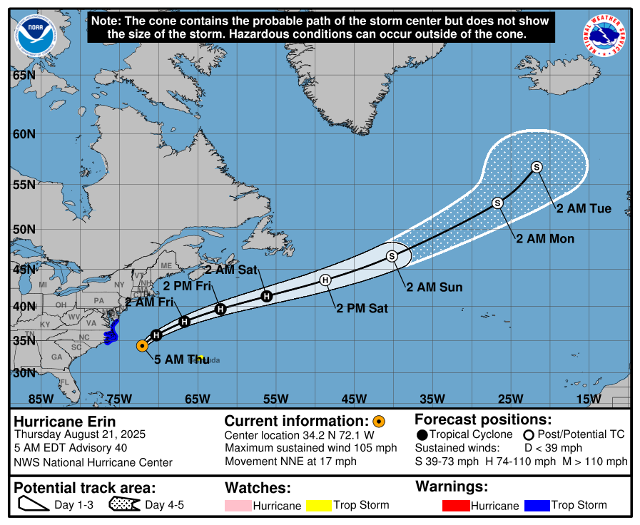
Following its closest approach, Hurricane Erin began moving away from the U.S. coast on August 21 as a category 2 hurricane.
As of 05:00 EDT (09:00 UTC) on August 21, Erin was located 330 km (205 miles) east-southeast of Cape Hatteras, North Carolina, and 708 km (440 miles) west-northwest of Bermuda.
Maximum sustained winds were 170 km/h (105 mph) and the storm was moving north-northeast at 27 km/h (17 mph). The estimated minimum central pressure was 945 hPa.
A Storm Surge Warning is in effect from Cape Lookout to Duck, North Carolina while a Tropical Storm Warning is in effect from Beaufort Inlet, North Carolina, to Chincoteague, Virginia, including Pamlico and Albemarle Sounds. A Tropical Storm Watch is in effect for Bermuda.
Life-threatening inundation and large waves continue along parts of the Outer Banks, resulting in beach erosion and overwash that has made some roads impassable.
Tropical storm conditions are ongoing along the North Carolina coast and are expected in Virginia on August 21. Gusts reaching tropical storm force are likely along the Mid-Atlantic and southern New England coasts through early August 23.
Swells generated by Erin are affecting the Bahamas, the U.S. East Coast, Bermuda, and Atlantic Canada, producing life-threatening surf and rip currents.
Tropical storm conditions are possible in Bermuda from the afternoon of August 21 through early August 23. Gale-force gusts are possible along the coast of Nova Scotia on August 23 and Newfoundland’s Avalon Peninsula on August 24.
Satellite imagery shows Erin’s low-level circulation embedded beneath a 167 km (90 nautical miles)-wide central dense overcast. Outer convective bands extend several hundred kilometers from the center. Erosion of clouds in the southwestern quadrant suggests increasing vertical wind shear.
Forecast guidance indicates the system will turn east-northeast on August 23 as it becomes embedded within mid-latitude westerlies, crossing the North Atlantic at speeds up to 65 km/h by the weekend.
The NHC expects gradual weakening over the next 36 hours, followed by more consistent weakening as the cyclone encounters increasing shear and more stable atmospheric conditions. Transition to a post-tropical system is projected in about 60 hours, though some models indicate this could occur within 36–48 hours.

I am an Assistant Editor and Severe Weather & Science Journalist at The Watchers, specializing in real-time severe weather coverage, geophysical event reporting, and research-driven scientific analysis. You can reach me at rishav(at)watchers(.)news.
Commenting rules and guidelines
We value the thoughts and opinions of our readers and welcome healthy discussions on our website. In order to maintain a respectful and positive community, we ask that all commenters follow these rules.