
Erin strengthens into a hurricane northeast of the Leeward Islands, rapid intensification expected over the weekend
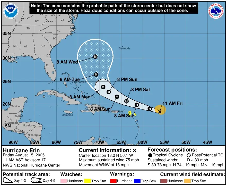
Hurricane Erin formed at 15:00 UTC on August 15, 2025, becoming the first hurricane of the 2025 Atlantic season. Current forecast calls for continued intensification and status of major hurricane over the weekend.

Satellite image of Hurricane Erin at 15:50 UTC on August 15, 2025. Credit: NOAA/GOES-East, RAMMB/CIRA, The Watchers
- Heavy rainfall expected tonight through Sunday across the northern Leeward Islands, the Virgin Islands, and Puerto Rico may lead to isolated and locally considerable flash and urban flooding, along with landslides or mudslides.
- Tropical storm conditions are possible for portions of the northern Leeward Islands, where Tropical Storm Watches are in effect, beginning on Saturday as the core of Erin passes north of those islands. Gusts to tropical storm force are possible in rainbands over portions of the Virgin Islands and Puerto Rico later in the weekend.
- While the threat of direct impacts in the Bahamas and along the east coast of the United States appears to be gradually decreasing, there will still be a significant risk of dangerous surf and rip currents along western Atlantic beaches next week.
- Interests in Bermuda should continue to monitor the progress of Erin since there is still a risk of strong winds, heavy rainfall, and high surf by the middle part of next week.
The center of Erin was located about 740 km (460 miles) east of the northern Leeward Islands at 15:00 UTC today, moving WNW at 30 km/h (18 mph). The system had maximum central pressure of 996 hPa, according to the National Hurricane Center (NHC).
A Tropical Storm Watch is in effect for Anguilla and Barbuda, St. Martin and St. Barthelemy, Saba and St. Eustatius, and Sint Maarten. However, NHC warned interests elsewhere in the northern Leeward Islands, Virgin Islands, and Puerto Rico to monitor the progress of Erin.
The system is expected to pass near or just north of the northern Leeward Islands on Saturday, August 16.
Forecast calls for steady and rapid intensification during the next two to three days, and reach major hurricane status late August 16 as it passes north of Puerto Rico and the Dominican Republic.
The light brownish-gray haze visible to the west and north of Hurricane Erin in the satellite image is dust associated with the Saharan Air Layer (SAL). The SAL is a hot, dry, and dust-laden air mass originating over the Sahara Desert that travels westward across the Atlantic at mid-levels of the atmosphere.
When it interacts with a tropical cyclone, it can suppress deep convection by introducing dry air into the storm’s circulation and increasing atmospheric stability.
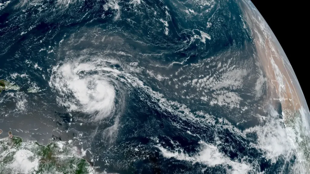
In Erin’s case, dust appears to be wrapping into the western semicircle of the storm, potentially limiting thunderstorm development on that side. While the cyclone is currently in an otherwise favorable environment for intensification, SAL intrusion can slow or disrupt organization, especially if the dry air penetrates into the eyewall.
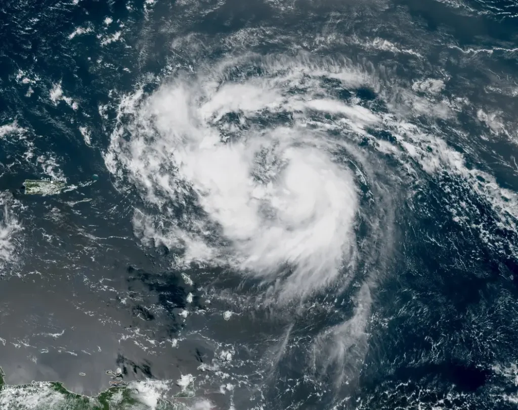
Despite this, ocean heat content along Erin’s forecast track is high, and the National Hurricane Center still expects significant strengthening over the next 36–48 hours.
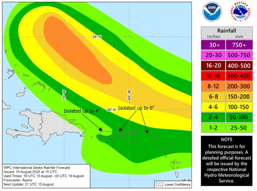
Rainfall totals of 50–100 mm (2–4 inches), with isolated amounts up to 150 mm (6 inches), are expected in the northern Leeward Islands, Virgin Islands, and Puerto Rico through Sunday, potentially causing flash flooding, urban flooding, and landslides or mudslides.
Swells generated by Erin are expected to cause life-threatening surf and rip current conditions in these areas and spread across the western Atlantic next week.
While the threat of direct impacts in the Bahamas and along the east coast of the United States appears to be gradually decreasing, there will still be a significant risk of dangerous surf and rip currents along western Atlantic beaches next week.
I'm a dedicated researcher, journalist, and editor at The Watchers. With over 20 years of experience in the media industry, I specialize in hard science news, focusing on extreme weather, seismic and volcanic activity, space weather, and astronomy, including near-Earth objects and planetary defense strategies. You can reach me at teo /at/ watchers.news.
Commenting rules and guidelines
We value the thoughts and opinions of our readers and welcome healthy discussions on our website. In order to maintain a respectful and positive community, we ask that all commenters follow these rules.