
126-year-old rain record broken in Charleston as heavy rain spreads across Southeast
Charleston, South Carolina, set a new daily rainfall record on Sunday, May 11, 2025, after a moisture-laden storm system brought prolonged periods of heavy rain to the region. The event marked the highest recorded precipitation for that date at Charleston International Airport, with widespread impacts extending across the Southeast and mid-Atlantic. Flash flood threats are expected to persist through Wednesday, May 14, according to the Weather Prediction Center (WPC).
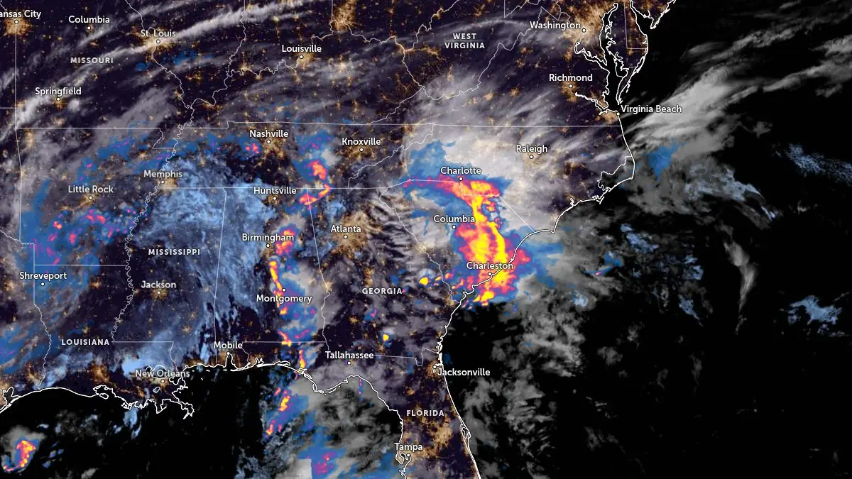
Satellite image with rainfall radar for southeast United States acquired at 09:00 UTC on May 11, 2025. Credit: NOAA/GOES-East, Zoom Earth, The Watchers
The National Weather Service (NWS) reported that Charleston International Airport in South Carolina, the city’s official climate station, recorded 50.5 mm (1.99 inches) of rainfall on Sunday, May 11. This surpassed the previous daily record for that date, 49 mm (1.93 inches), set in 1952.
On the same day, downtown Charleston also saw a new daily rain record, receiving 52.3 mm (2.06 inches) and breaking the 126-year-old record of 39.8 mm (1.57 inches) set in 1899.
The rainfall caused flash flooding and rendered multiple roads impassable across the city. Localized street flooding was reported, with several vehicles stranded in submerged areas. The NWS issued flash flood warnings, advising residents to avoid travel on water-covered roads due to the risk of rapid water level rises.
Heavy rainfall associated with the Gulf storm also affected parts of Florida. At the Northwest Florida Beaches International Airport in Panama City, 19.05 mm (0.75 inches) of rain fell within just eight minutes between 03:56 and 04:04 local time on Sunday. This corresponds to a rainfall rate of 143 mm (5.63 inches) per hour. The two-hour total from 03:00 to 05:00 LT reached 57.4 mm (2.26 inches).
The storm system is forecast to continue producing thunderstorms and heavy rainfall across the Southeast and mid-Atlantic through the early part of the week.
In southeast Florida, a Moderate Risk (level 3 of 4) was issued for heavy rainfall over densely urbanized metropolitan areas. A Marginal Risk (level 1 of 4) extended northwestward into the Ozarks and the Middle Mississippi Valley due to the potential for flash flooding through Monday.
WPC maintains a Slight Risk (level 2/4) for excessive rainfall from Virginia through the Carolinas into southwestern Florida through Monday, May 12.

The storm will move eastwards through the Ohio and Tennessee Valleys on Tuesday, May 13, with the heaviest rain focused over the mid-Atlantic. A Slight Risk will remain in place over the Mid-Atlantic, while the Marginal Risk will extend as far west as the upper Ohio Valley and southern Appalachians through Tuesday.

Through early Wednesday morning, May 14, the Blue Ridge Mountains of North Carolina and Virginia are likely to see the heaviest rainfall due to the southeasterly flow providing enhanced upslope rainfall rates over the higher terrain.
Around 76 to 127 mm (3 to 5 inches) of rainfall is forecast over the Blue Ridge, with localized amounts approaching 178 mm (7 inches) being possible in some areas. The Virginia Piedmont could also receive as much as 51 to 102 mm (2 to 4 inches) of rainfall due to the storm.
In the West, an incoming storm system will usher in widespread showers (snow for the higher terrain of the Northern Rockies) and much cooler temperatures over the Pacific Northwest today, then throughout the western third of the CONUS by Tuesday.

I am an Assistant Editor and Severe Weather & Science Journalist at The Watchers, specializing in real-time severe weather coverage, geophysical event reporting, and research-driven scientific analysis. You can reach me at rishav(at)watchers(.)news.
Commenting rules and guidelines
We value the thoughts and opinions of our readers and welcome healthy discussions on our website. In order to maintain a respectful and positive community, we ask that all commenters follow these rules.