
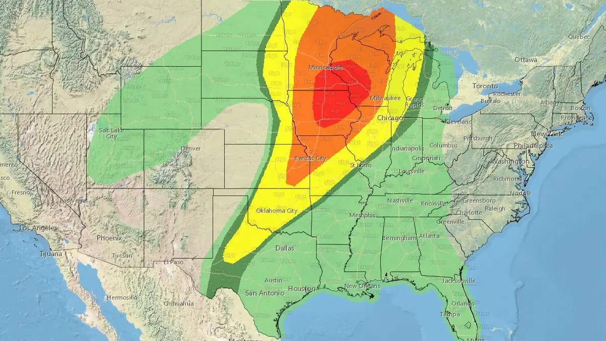
Severe weather outbreak forecast across Midwest and Upper Midwest on April 28, 2025
A severe weather outbreak is forecast across parts of the Midwest and Upper Midwest on Monday, April 28, 2025, with threats including large hail, severe wind gusts, and strong to intense tornadoes, according to the NWS Storm Prediction Center (SPC). The greatest risk is expected across southeastern Minnesota, northeastern Iowa, and southwestern Wisconsin, including cities such as St. Paul, Des Moines, and Cedar Rapids.
Categorical outlook for Monday, April 28, 2025. Image credit: NWS
An outbreak of severe weather is expected across portions of the Midwest and Upper Midwest on Monday, April 28, 2025, according to the U.S. National Weather Service’s Storm Prediction Center (SPC). All severe hazards are possible, including strong to intense tornadoes, very large hail over 5 cm (2 inches) in diameter, and severe wind gusts up to 120 km/h (75 mph).
SPC forecasters note that a strong mid-level jet streak will move rapidly northeastward from the Southwest to the Upper Midwest during the day. As this occurs, a surface low-pressure system will deepen and progress from the northern Plains to the northern Great Lakes.
Strong southwesterly low-level flow is expected to advect high theta-e air (equivalent potential temperature, a measure of heat and moisture in an air parcel) northward across the Midwest and into parts of the Upper Midwest. Broken to scattered cloud cover will allow for surface heating and strong destabilization across the warm sector, particularly in Iowa, southeastern Minnesota, and western Wisconsin.
Severe thunderstorms may initiate as early as midday across western Minnesota and western Iowa, forming initially as supercells on the nose of a 130–150 km/h (70–80 mph) mid-level jet streak. As the cold front advances and intersects the dryline across Minnesota during the afternoon, storm mode may evolve into a more linear structure. Despite this transition, embedded tornadoes will remain possible due to strengthening low-level shear.
Farther south and east, a more discrete storm mode is expected to develop within a weakly capped warm sector. As low-level flow strengthens through the day, the warm sector is forecast to expand rapidly northeastward, featuring moderate to strong instability and very strong wind shear exceeding 110 km/h (60 mph).
Increasing atmospheric forcing during the afternoon is anticipated to overcome residual capping, allowing for the development of open warm-sector supercells. Any supercells forming within this environment during the afternoon and evening hours will be capable of producing strong to intense tornadoes.
By late evening, a squall line is expected to overtake much of the discrete convection as the cold front advances rapidly southeastward. Severe wind gusts and embedded tornadoes will remain possible through late evening and potentially into the overnight hours.
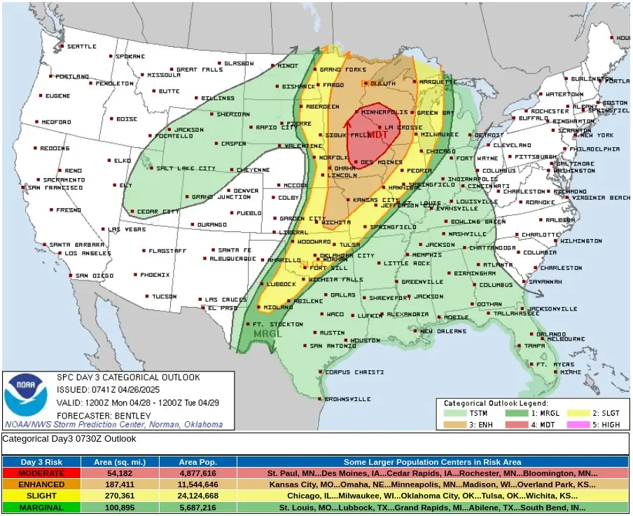
The highest concentration of severe weather impacts on April 28 is forecast across southeastern Minnesota, northeastern Iowa, and southwestern Wisconsin, within a moderate risk area outlined by the SPC.
This zone includes a population of approximately 4.87 million people and covers key urban areas such as St. Paul and Bloomington in Minnesota, Des Moines and Cedar Rapids in Iowa, and Rochester, Minnesota.
Major transportation infrastructure, including Interstate 35, Interstate 90, and Interstate 80, passes through this region, raising concerns for significant travel disruptions during the peak of severe storm activity. Minneapolis–Saint Paul International Airport (MSP) and Des Moines International Airport (DSM) are among the larger airports located within or near the moderate risk zone, potentially facing delays or operational impacts depending on storm timing and severity.
The enhanced risk zone extends across portions of Kansas, Missouri, Nebraska, Iowa, Minnesota, and Wisconsin, affecting an estimated 11.54 million people. Prominent cities within this risk area include Kansas City in Missouri, Omaha in Nebraska, Minneapolis in Minnesota, Madison in Wisconsin, and Overland Park in Kansas.
This broader zone also encompasses critical sections of Interstate 70, Interstate 29, and Interstate 35, corridors heavily utilized for freight and passenger traffic. Airports such as Eppley Airfield (OMA) in Omaha, Kansas City International Airport (MCI), and Dane County Regional Airport (MSN) in Madison are located within the enhanced risk zone.
While all types of severe weather hazards are possible, the primary risks to urban and suburban areas involve damaging wind gusts, localized tornadoes, and large hail, particularly in the late afternoon and evening hours as storm modes evolve.
Additionally, a strongly unstable and sheared warm sector is forecast to persist along and east of the dryline from eastern Kansas southward into West Texas.
Although large-scale forcing is weaker in this region compared to areas farther north, minimal convective inhibition along the dryline is expected to allow for at least isolated storm development. Some enhancement may occur due to a nocturnal increase in the low-level jet. Any supercells that form along the dryline will be capable of all severe hazards, including the potential for strong tornadoes.
References:
1 Day 3 Convective Outlook – NWS/SPC – Issued at 02:41 CDT on April 26, 2025
I'm a dedicated researcher, journalist, and editor at The Watchers. With over 20 years of experience in the media industry, I specialize in hard science news, focusing on extreme weather, seismic and volcanic activity, space weather, and astronomy, including near-Earth objects and planetary defense strategies. You can reach me at teo /at/ watchers.news.
Commenting rules and guidelines
We value the thoughts and opinions of our readers and welcome healthy discussions on our website. In order to maintain a respectful and positive community, we ask that all commenters follow these rules.