
Red alerts issued as extremely dangerous Storm Éowyn approaches Ireland and UK
Met Éireann, Ireland’s national meteorological service, has issued Red Level wind warnings for multiple counties as Storm Éowyn approaches the country on January 23, 2025. Éowyn is forecast to produce destructive gusts exceeding 130 km/h (81 mph), potentially causing widespread power outages, structural damage, dangerous travel conditions, and coastal flooding. Authorities have urged the public to shelter in place under Red warnings and avoid non-essential travel under Orange warnings. Schools nationwide will close, and disruptions to public transport and essential services are anticipated.
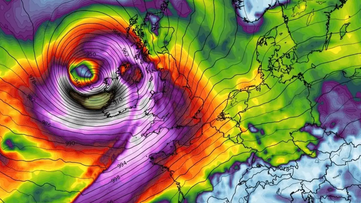
Storm Éowyn peak wind gust at 03:00 UTC on January 24, 2025. Credit: WXCHARTS
- Winds expected to be produced by Storm Éowyn have the potential to pose a threat to life and property, so the public is advised to shelter in place under any Red level warning, and limit travel to essential only and shelter in place as much as possible under any Orange warning, as there will be extremely dangerous travelling conditions, fallen trees, and power outages expected broadly.
- There is a potential for wave over-topping and coastal flooding in low-lying, exposed Atlantic coastal areas.
- Éowyn will also bring heavy rain followed by showers, potentially leading to localised surface flooding, which may prevail into Saturday.
- The electricity network is expected to be severely impacted, the public are advised to prepare for the arrival of the storm including ensuring their mobile phone is fully charged to enable communication.
- Red Warnings for wind have been issued for Northern Ireland as well as central and southwestern areas of Scotland on Friday. These are accompanied by wider Amber and Yellow Warnings for wind, as well as Yellow Warnings for rain and snow.
- This is the first Red Warning issued for Northern Ireland since the Met Office moved to impact-based warnings in 2011.
An extremely dangerous winter storm named Storm Éowyn will impact Ireland on Thursday night, January 23, bringing damaging and destructive wind gusts in excess of 130 km/h (81 mph) across the country before heading into the United Kingdom.
Éowyn will begin to influence the UK’s weather early on Friday, with strengthening winds initially in southwestern parts of the UK with accompanying heavy rainfall. This will quickly spread northeast to the rest of the UK on Friday morning.
Multiple red alerts have been issued for both Ireland and the UK, with Northern Ireland seeing the first Red Warning since the Met Office moved to impact-based warnings in 2011.
Ireland
“This is a nationwide multi-hazard event, with the potential to be very destructive,” Met Eireann meteorologists warned.
Éowyn is expected to bring dangerous conditions across Ireland, with a significant threat to life due to extreme wind speeds and hazardous weather.
Traveling will be extremely dangerous, with fallen trees, debris, and poor visibility, especially in areas experiencing sleet or snow, though wintry conditions will be mostly transient and limited to the northwest. High seas and wave overtopping due to strong onshore winds are expected to cause coastal flooding in low-lying and exposed areas along the Atlantic coast, including Bantry, Salthill, Galway Bay, and Donegal Bay.
Structural damage is likely in areas experiencing the strongest winds, increasing risks for those working in exposed environments. The storm will also create unsafe working conditions, particularly for outdoor and high-risk jobs, where strong gusts and flying debris could pose serious hazards.
Widespread power outages are expected, which could impact essential services and infrastructure.
Transport disruptions and cancellations are expected across bus, rail, and air travel, with public services potentially affected. Events may be canceled or postponed due to the hazardous conditions.
Additionally, heavy rainfall combined with already saturated ground increases the risk of surface water flooding across the country, which may persist into Saturday.
Authorities are advising the public to take necessary precautions and follow official guidance to minimize risks and ensure safety.
United Kingdom
The UK Met Office has also issued Red Weather Warnings for Northern Ireland as well as central and southwestern areas of Scotland on Friday. These are accompanied by wider Amber and Yellow Warnings for wind, as well as Yellow Warnings for rain and snow.
“Storm Éowyn is a multi-hazard event, with snow likely for some, rain for many and strong winds for much of the UK,” Met Office Chief Meteorologist Paul Gundersen said.
As a result, a number of weather warnings have been issued, with all parts of the UK covered by one warning at some point on Friday.
The storm is expected to cross Northern Ireland early on Friday morning and then continue northeast across the northern half of Scotland during Friday afternoon and is expected to be centered near Shetland during Friday evening.
“We reserve the issuing of Red Warnings for the most severe weather which represents a likely danger to life and severe disruption, and that is the case with Storm Éowyn,” Gundersen said.
“It’s important to note that even those away from the immediate Red Warning areas will still likely see disruptive weather, with travel plans likely to be severely impacted, as well as the possibility of power cuts for some.”
While it will be widely very windy on Friday, with additional hazards from rain and snow, the strongest winds and most significant impacts are likely in Northern Ireland and central and southwestern parts of Scotland within the Red Warning areas, where winds could gust 130 – 145 km/h (80 – 90 mph) quite widely for a time, and potentially up to 160 km/h (100 mph) for exposed coasts in particular.
This is the first Red Warning issued for Northern Ireland since the Met Office moved to impact-based warnings in 2011.
There is also a chance of snow over Northern Ireland, northern England and Scotland as the system initially bumps into cold air, however much of this will quickly change to rain as milder air moves in.
Met officials are urging residents to be prepared for weather warnings to change quickly.
Éowyn is the fifth storm of the 2024/25 European storm season.
References:
1 Storm Éowyn has been named – Status Update – Met Eireann – January 22, 2025
2 Red weather warnings issued with damaging winds forecast for Storm Éowyn – UK Met Office – January 23, 2025
I'm a dedicated researcher, journalist, and editor at The Watchers. With over 20 years of experience in the media industry, I specialize in hard science news, focusing on extreme weather, seismic and volcanic activity, space weather, and astronomy, including near-Earth objects and planetary defense strategies. You can reach me at teo /at/ watchers.news.
Commenting rules and guidelines
We value the thoughts and opinions of our readers and welcome healthy discussions on our website. In order to maintain a respectful and positive community, we ask that all commenters follow these rules.