
Family of atmospheric rivers to bring heavy rain, flood, and snow to the U.S. West Coast
A series of atmospheric rivers (ARs) is forecast to bring heavy precipitation, flooding risks, and winter storm impacts to the U.S. West Coast this week, with the first AR making landfall on Tuesday, December 17, 2024. The fourth and fifth ARs are forecast to make landfall on December 21 and 22. Up to 500 mm (20 inches) of rain expected in some areas and significant streamflow rises in western Washington and Oregon.

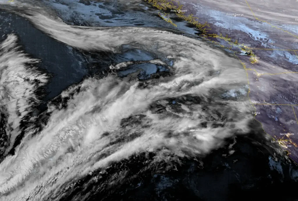
The Atmospheric river developing over North Pacific. Image credit: NOAA/GOES-West, Zoom Earth, The Watchers. Acquired at 09:40 UTC on December 17, 2024
- A series of atmospheric rivers (ARs) is expected to bring significant rainfall to the U.S. West Coast, with totals reaching 250 – 500 mm (10 – 20 inches) over the Olympic Peninsula.
- Many stream gauges in western Washington and Oregon are forecast to exceed bankfull levels, increasing the risk of flooding, particularly midweek.
- Freezing levels in the Pacific Northwest will rise significantly after the first AR, increasing runoff potential.
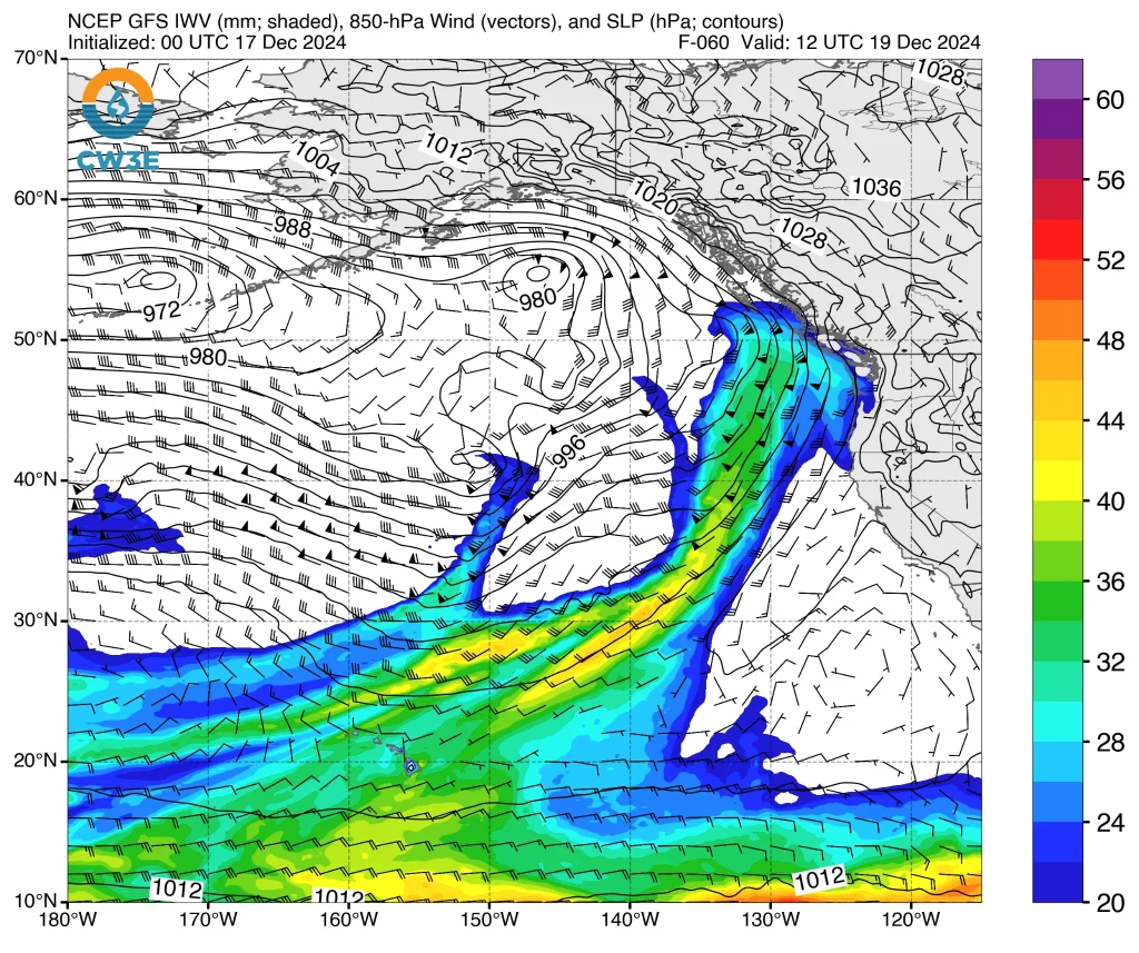
A family of atmospheric rivers (ARs) is forecast to develop over the North Pacific and propagate toward the U.S. West Coast through the end of the week, meteorologists at the Center for Western Weather and Water Extremes (CW3E) said in their December 16 AR update.
The eastward expansion of the North Pacific Jet Stream and the development of a broad, persistent upper-level trough over the North Pacific will facilitate a prolonged period of active weather over the U.S. West Coast.
The development and eastward movement of the ARs will be supported by large-scale dynamic and low-pressure systems over the next 10 days.
The first AR is forecast to make landfall in the early hours of Tuesday, December 17, bringing AR2/AR3 conditions and heavy precipitation to coastal Washington and northern Oregon. The core of the AR will move onshore Tuesday night, bringing strong AR conditions (IVT > 750 kg m⁻¹ s⁻¹) to the region.
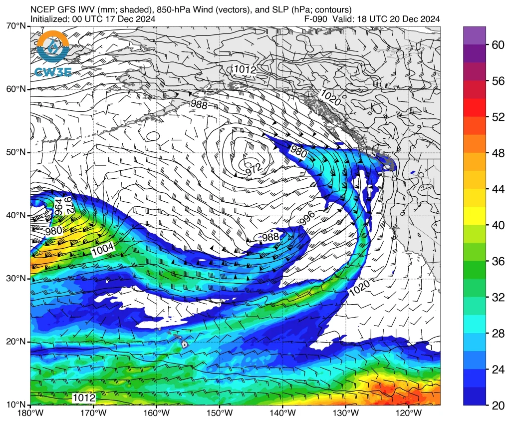
The second and third ARs are forecast to make landfall over British Columbia on Thursday and Friday, December 19 and 20, with some impact on the U.S. West Coast.
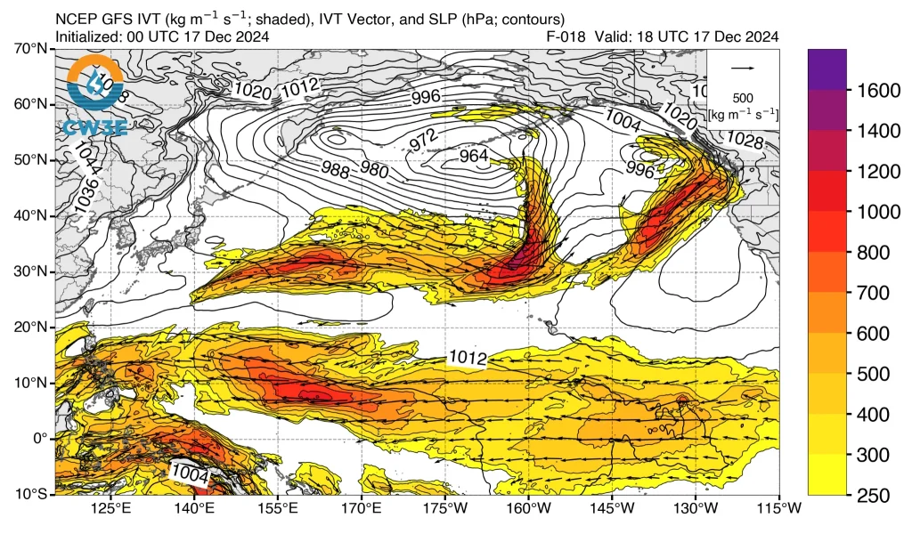
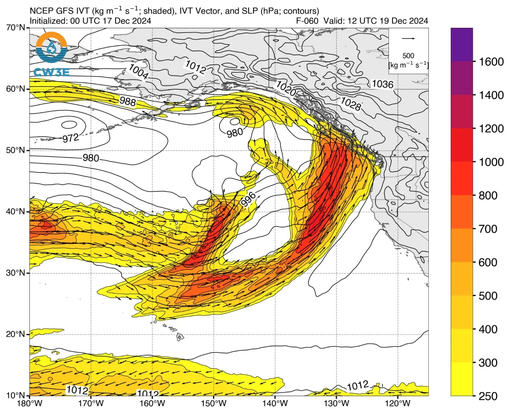
Southwesterly IVT during the second AR will likely support the orographic enhancement of precipitation over the Olympic Mountains and North Cascades. It will eventually move eastward into western Washington before rapidly weakening.
The third AR will follow a trajectory similar to the second AR. Both the second and third ARs are likely to have limited impacts outside the Olympic Peninsula due to the strongest IVT remaining offshore and a primarily southerly IVT direction.
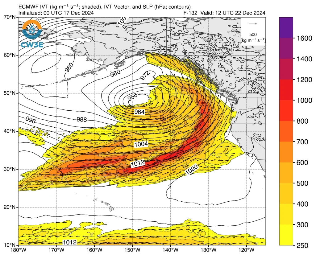
Heavy precipitation is expected over western Washington, western Oregon, and northern California as the fourth and fifth ARs make landfall on Saturday and Sunday, December 21 and 22. These ARs are likely to bring moderate-to-strong AR conditions (IVT > 500 kg m⁻¹ s⁻¹).
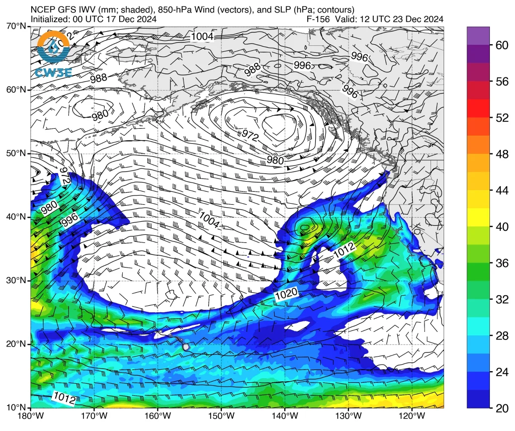
The National Weather Service (NWS) Weather Prediction Center (WPC) is forecasting 250 – 500 mm (10 – 20 inches) of total precipitation over the Olympic Peninsula through this week. Forecast models suggest additional AR activity and wet conditions are likely to continue into next week.
The first AR is forecast to produce 75 – 180 mm (3 – 7 inches) of precipitation over the coastal ranges and Cascades in Washington and northern Oregon, with the possibility of over 250 mm (10 inches) in the Olympic Mountains.
The second and third ARs are forecast to produce roughly 25 – 75 mm (1 – 3 inches) of precipitation over the Olympic Peninsula and North Cascades, as the strongest IVT will remain offshore.
The uncertainty in predicting the development of ARs and shortwave troughs is affecting the accuracy of precipitation forecasts. Generally, the European Ensemble Prediction System (EPS) predicts higher rainfall totals for coastal Washington and Oregon over the next 10 days than the Global Ensemble Forecast System (GEFS).
Many stream gauges in western Washington and Oregon are expected to exceed their action or bankfull levels in the next 10 days. High freezing levels combined with heavy rain will likely lead to increased runoff and a higher risk of flooding during the first AR event.
The Northwest River Forecast Center forecasts 20 stream gauges in western Oregon and Washington to rise above bankfull levels in the next 10 days. Flooding is most likely to occur in western Washington and northwestern Oregon on Wednesday and Thursday, December 18 and 19, due to heavy rains triggered by the first AR.
Another round of high streamflow and flooding is likely next week due to additional precipitation from subsequent ARs.
Freezing levels over the Pacific Northwest are expected to rise rapidly after the first AR makes landfall. The 12z GEFS forecasts freezing levels in the Snoqualmie Watershed to rise from below 915 m (3 000 feet) early Tuesday morning to above 2 135 m (7 000 feet) by the evening.
High freezing levels will result in a significant portion of the precipitation falling as rain, increasing runoff and flood potential during the first AR.
Snowfall accumulations of 30 – 75 cm (12 – 30 inches) are forecast above 2 135 m (7 000 feet) in the Washington and Oregon Cascades, with moderate-to-major winter storm impacts expected in these regions.
References:
1 CW3E AR Update: 16 December 2024 Outlook – CW3E – December 16, 2024

I am an Assistant Editor and Severe Weather & Science Journalist at The Watchers, specializing in real-time severe weather coverage, geophysical event reporting, and research-driven scientific analysis. You can reach me at rishav(at)watchers(.)news.
Commenting rules and guidelines
We value the thoughts and opinions of our readers and welcome healthy discussions on our website. In order to maintain a respectful and positive community, we ask that all commenters follow these rules.