
Extreme rainfall hits Ardèche Cévennes with up to 700 mm (27.6 inches) in 24 hours, France
A slow-moving storm brought extremely heavy rains to parts of France on Thursday, October 17, 2024, with the Ardèche Cévennes region experiencing rainfall totals as high as 700 mm (27.6 inches). This led to widespread flooding and approximately 350 rescue operations. Agnès Pannier-Runacher, Minister of Ecological Transition, said the region is facing a situation that is unprecedented in its scale.
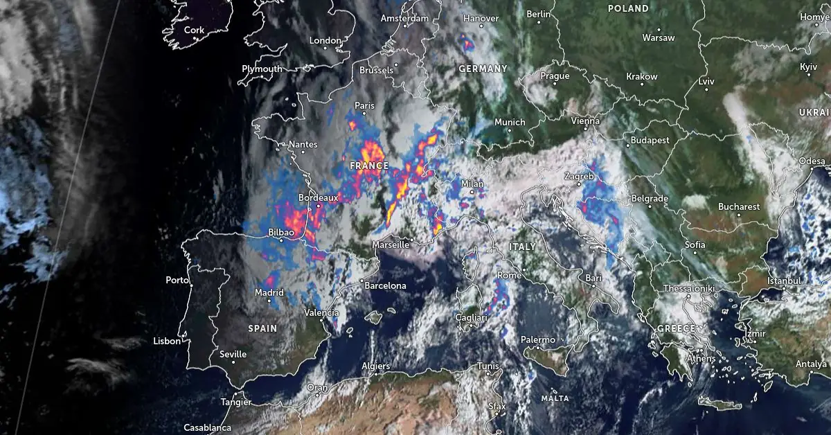
Image credit: EUMETSAT/Meteosat-11, Zoom Earth, The Watchers
- The Ardèche Cévennes region was hit by extremely heavy rainfall on Thursday, with some locations receiving over 500 mm (19.7 inches) of rain within 24 hours. Croix-de-Bauzon recorded the highest rainfall at 700 mm (27.6 inches) by 12:00 (LT).
- Agnès Pannier-Runacher, Minister of Ecological Transition, said the region is facing a situation that is unprecedented in its scale.
- Severe flooding in towns like Annonay led to evacuations and the activation of safeguard plans. Firefighters conducted around 350 interventions, rescuing 500 people, with no fatalities reported but three minor injuries.
- Six departments were placed under Red alert for rain and flooding, and schools in Ardèche were closed as a precaution. Twenty departments remained on Orange alert, with continued heavy rainfall forecast.
- The heavy rainfall was caused by the interaction of a quasi-stationary low-pressure area, an unstable air mass from the Mediterranean, and a “cold drop” created by cyclonic vorticity. This resulted in intense storm convection over the Cévennes mountains known as the Cevennes episode.
A slow-moving storm formed between Spain and western France late Wednesday, October 16, bringing extremely heavy rainfall to parts of France through October 17.
As of 09:00 local time (LT) on Thursday, parts of the Ardèche Cévennes region have received between 300 and 500 mm (11.8 – 19.7 inches) of rain in 24 hours leading to severe floods across the region.
Some locations recorded more than 500 mm (19.7 inches) of rain in 24 hours, such as Loubaresse, which registered 523 mm (20.6 inches), and Mayres, which saw 508 mm (20 inches) of rainfall. However, the highest accumulation was recorded at Croix-de-Bauzon, with 700 mm (27.6 inches) of rainfall as of 12:00 LT on Thursday.
“We are facing a situation that is unprecedented in its scale,” said Agnès Pannier-Runacher, Minister of Ecological Transition. “600 mm (23.6 inches) of water in the Ardèche is unheard of! That’s more than 600 mm in 48 hours. It’s absolutely massive,” she added.
Other parts of the region also received significant rainfall, such as Barnas, which recorded 450 mm (17.7 inches), and the Ardèche Plateau, which saw 305 mm (12 inches) in 24 hours.
Between 100 and 200 mm (3.9 – 7.9 inches) of rain is still forecast for the next 48 hours, with the Ardèche area expected to have received a total of 400 – 700 mm (15.7 – 27.6 inches) by the end of this period.
Schools across Ardèche were suspended by midday on Thursday and will remain closed on Friday due to the rain and flooding.
The Orange alert for Ardèche was upgraded to Red on Thursday at 10:00 LT and will remain in effect until 22:00 LT the same day. Currently, six departments are under Red alert: Lozère, Rhône, Loire, and Haute-Loire for floods, and Alpes-Maritimes and Ardèche for rain and flooding.
Twenty departments across France are on Orange alert for rain and flooding until Thursday night.
The town of Annonay was also severely affected by flooding after receiving 120 mm (4.7 inches) of rainfall in 24 hours. The town hall had activated its communal safeguard plan by 10:00 LT on Thursday. Schools and daycares were evacuated, shops were closed, and the town center was sealed off due to the flooding.
According to the report provided by the prefect of Ardèche, firefighters carried out around 350 interventions. Although no fatalities were reported, three people suffered minor injuries in Annonay.
A total of 500 rescues were carried out, including 120 from six campsites in Ardèche, and 250 people were rescued from dangerous situations caused by the extreme weather.
The 320 Ardèche firefighters were reinforced by 150 firefighters from other departments. Four helicopters were mobilized for rescues and reconnaissance.
All rivers in the affected regions have swollen and been placed under Orange alert. Reports suggest that the Ardèche at Pont-d’Ucel exceeded the level of the December 2003 flood by nearly 70 cm (27.6 inches). At 05:15 LT on Thursday, the river was at 3.49 m (11.5 feet). At Rosières, the Baume River also rose higher than the flood of August 2004.
The floods and swollen rivers have also triggered several landslides, causing multiple road closures across the affected region. The A47 rail route has also been closed due to floodwaters, leading to train cancellations. Rail traffic is expected to be halted for several days.
The Ardèche Cévennes is a region in southeastern France that forms part of the larger Cévennes mountain range, situated in the southern section of the Massif Central. This area is known for its dramatic weather patterns, particularly in autumn, when Mediterranean air masses bring heavy rainfall.
The region is especially prone to Cévennes episodes—prolonged rain events that often lead to significant flooding. These events are driven by orographic lift, where moisture-laden air from the Mediterranean is forced upward by the mountains, cooling and condensing to produce heavy precipitation.
The Ardèche Cévennes is a key area for these episodes, given its proximity to both the Mediterranean Sea and the southern slopes of the Cévennes, making it particularly vulnerable to intense rainfall.
The formation of these rain events is driven by a combination of altitude forcing, convective instability, and orographic enhancement. These factors are further intensified by the presence of dry stratospheric air and cyclonic vorticity, which results in deep stormy convection.
Because the entire weather system during these episodes can remain quasi-stationary, stormy rains are able to persist over the same areas for extended periods, leading to massive rainfall accumulations. This stationary nature is a common feature of Cévennes episodes, where large-scale weather systems remain locked in place, causing intense and prolonged rain events.
References:
1 Foehn en Suisse et épisode cévenol en France – MeteoSuisse – October 17, 2024
2 EN DIRECT – De nouvelles pluies attendues dans la soirée, ne sortez pas après 18h demande la préfecture – France Bleu – October 17, 2024

I am an Assistant Editor and Severe Weather & Science Journalist at The Watchers, specializing in real-time severe weather coverage, geophysical event reporting, and research-driven scientific analysis. You can reach me at rishav(at)watchers(.)news.
Commenting rules and guidelines
We value the thoughts and opinions of our readers and welcome healthy discussions on our website. In order to maintain a respectful and positive community, we ask that all commenters follow these rules.