
Hurricane “Francine” to hit Louisiana today with powerful winds and dangerous storm surge, U.S.
Hurricane “Francine” is forecast to make landfall along the Louisiana coast, between the Vermilion/Cameron line and Grand Isle, on Wednesday, September 11, 2024.
A life-threatening storm surge and hurricane-force winds are expected, with warnings in effect across Louisiana and Mississippi. The storm is also forecast to bring heavy rainfall, increasing the risk of flash flooding across the region through Thursday.

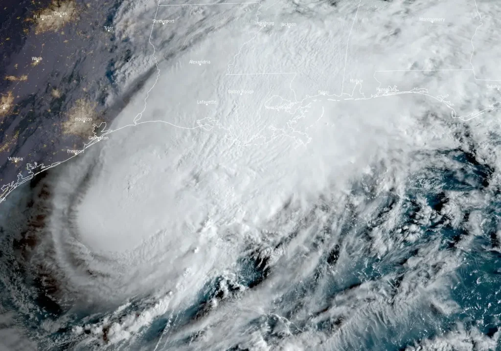
Featured image: 50 UTC on September 11, 2024. Credit: NOAA/GOES-East, RAMMB/CIRA, The Watchers
- Tropical Storm “Francine” intensified into a hurricane at 00:00 UTC on September 10, 2024, around 560 km (350 miles) SW of Morgan City, Louisiana.
- Landfall is forecast along the Louisiana coast, between the Vermilion/Cameron line and Grand Isle, on Wednesday, September 11.
- A life-threatening storm surge is expected today along the coastlines of Louisiana and Mississippi, where a Storm Surge Warning is currently in effect. Residents in these areas should adhere to advice and evacuation orders issued by local authorities.
- Damaging, life-threatening hurricane-force winds are forecast for southern Louisiana later today, with a Hurricane Warning in place. Tropical storm conditions are expected to develop in the region this morning, and preparations to safeguard life and property should already be completed.
- Francine is expected to bring heavy rainfall with a significant risk of flash and urban flooding in southeastern Louisiana, Mississippi, far southern Alabama, and northern Florida through Thursday night. Flash and urban flooding is likely across the Lower Tennessee Valley and Lower Mississippi Valley from Wednesday night into Friday morning.
Louisiana Governor Jeff Landry has officially requested a Presidential Emergency Declaration for the State of Louisiana in anticipation of the severe impacts of Hurricane “Francine.” In a letter sent to President Joe Biden, Governor Landry asked for the emergency declaration to be effective as of September 9, 2024, to ensure swift federal assistance in response to the approaching storm.
The request comes as Louisiana faces the threat of torrential rainfall, damaging winds, and tornadoes spawned by the hurricane, which could endanger both lives and property across the state. Governor Landry said that the severity of the storm exceeds the capacity of state and local governments to respond effectively.
“After declaring a State of Emergency, we have now determined that this storm is of such severity that an effective response is beyond the capabilities of the state and local governments. This federal assistance is needed to save lives and property, and I look forward to President Biden quickly approving this request,” Landry said.
“As expected, Francine has strengthened and become better organized overnight,” NHC forecaster Reinhart said at 09:00 UTC on September 11.
“Radar data and earlier reports from the Air Force Hurricane Hunters indicate the eyewall is better defined, with deep convection wrapping around the center of the hurricane. The eyewall has contracted a bit from earlier, although it was open to the south on the last fix and in more recent GMI passive microwave images.”
At 12:00 UTC the center of Hurricane “Francine” was located about 315 km (195 miles) SW of Morgan City. The system had maximum sustained winds of 150 km/h (90 mph) and a minimum central pressure of 976 hPa, according to the National Hurricane Center (NHC).
Francine is moving northeast at 19 km/h (12 mph), with a faster northeastward motion expected later today.
The storm is forecast to make landfall in Louisiana within the warning area this afternoon or evening.
After landfall, a gradual turn toward the north will bring the center of Francine across eastern Louisiana and Mississippi.
A Storm Surge Warning is currently in effect for areas from Cameron, Louisiana, to the Mississippi/Alabama border, including Vermilion Bay, Lake Maurepas, and Lake Pontchartrain. This means that dangerous storm surges are expected in these regions.
A Hurricane Warning covers the Louisiana coast from the Vermilion/Cameron line to Grand Isle, indicating that hurricane conditions are imminent.
A Storm Surge Watch extends from the Mississippi/Alabama border to the Alabama/Florida border, including Mobile Bay, while a Hurricane Watch applies to Lake Maurepas and Lake Pontchartrain, including New Orleans.
Additionally, a Tropical Storm Warning is in effect for the Louisiana coast east of Sabine Pass to the Vermilion/Cameron line, Grand Isle to the Alabama/Florida border, as well as for Lake Maurepas and Lake Pontchartrain, including the New Orleans metro area.
Hurricane conditions are expected in the hurricane warning area this afternoon, with tropical storm conditions arriving this morning. Hurricane conditions may occur in the hurricane watch area later this afternoon and into the night.
Tropical storm conditions are forecasted along the coasts of Louisiana, Mississippi, and Alabama throughout today and into tonight.

Francine is forecasted to bring total rainfall of 100 – 200 mm (4 – 8 inches), with localized amounts reaching up to 300 mm (12 inches) across southeastern Louisiana, Mississippi, far southern Alabama, and the Florida Panhandle through Thursday night. This level of rainfall could cause significant flash and urban flooding.
A combination of storm surge and tides is expected to flood typically dry coastal areas with rising waters moving inland. If the peak surge coincides with high tide, water levels could reach the following heights above ground in these areas:
- Intracoastal City, LA to Port Fourchon, LA: 1.5 – 3 m (5 – 10 feet)
- Vermilion Bay: 1.5 – 3 m (5 – 10 feet)
- Port Fourchon, LA to the Mouth of the Mississippi River, LA: 1.2 – 2.1 m (4 – 7 feet)
- Mouth of the Pearl River, LA to Ocean Springs, MS: 1.2 – 1.8 m (4 – 6 feet)
- Lake Pontchartrain: 1.2 – 1.8 m (4 – 6 feet)
- Ocean Springs, MS to the MS/AL Border: 0.9 – 1.5 m (3 – 5 feet)
- Cameron, LA to Intracoastal City, LA: 0.9 – 1.5 m (3 – 5 feet)
- Lake Maurepas: 0.9 – 1.5 m (3 – 5 feet)
The deepest water is likely to occur along the immediate coast, near and to the east of the landfall location, where the surge will combine with large, hazardous waves. Surge-related flooding will vary significantly depending on the timing of the surge and the tide. Storm surge is not expected to threaten the risk reduction system levees, but there may be minor overtopping of local levees.
A few tornadoes are possible today and tonight across southeastern Louisiana, southern Mississippi, southern Alabama, and the Florida Panhandle.
Swells generated by Francine are impacting much of the northern and northwestern Gulf Coast, likely producing dangerous surf and rip currents.
References:
1 Hurricane Francine Intermediate Advisory Number 11A – NWS/NHC – Issued at 12:00 UTC on September 11, 2024
2 Hurricane Francine Discussion Number 11 – NWS/NHC – Issued at 09:00 UTC on September 11, 2024
3 Governor Landry Requests Presidential Emergency Declaration – Louisiana Government – September 10, 2024
I'm a dedicated researcher, journalist, and editor at The Watchers. With over 20 years of experience in the media industry, I specialize in hard science news, focusing on extreme weather, seismic and volcanic activity, space weather, and astronomy, including near-Earth objects and planetary defense strategies. You can reach me at teo /at/ watchers.news.
Commenting rules and guidelines
We value the thoughts and opinions of our readers and welcome healthy discussions on our website. In order to maintain a respectful and positive community, we ask that all commenters follow these rules.