
Europe braces for extreme rainfall and flooding as heat dome collapses
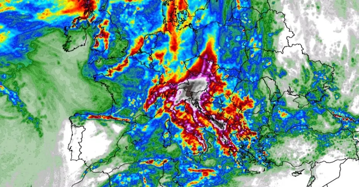
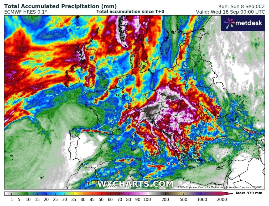
Featured image: Total rainfall accumulation September 8 - 14, 2024. Credit: WX Chards, ECMWF
As a prolonged heat dome collapses, signaling the end of summer, Europe is set to experience a dramatic shift in weather. Severe storms, heavy to extreme rainfall, and even early snowfalls are forecast for parts of the Mediterranean and Alpine regions in the coming days.
- The collapse of the heat dome has paved the way for more active weather patterns across Europe, with a mix of warm, moist air from the Mediterranean and cold air masses moving south from northern Europe. This combination is likely to produce severe storms, flooding, and even early snowfall in the Alps.
- Meteorological models, such as the European Centre for Medium-Range Weather Forecasts (ECMWF), predict substantial rainfall over the next 10 days, particularly along the Dynaric mountain range and the Alpine region. Some areas could see 200 – 400 mm (7.9 – 15.7 inches) of rainfall, with local anomalies likely to increase these amounts even further.
- The heavy rainfall could lead to widespread flooding across parts of northern Italy, Austria, Slovenia, and Croatia. The second system, expected to arrive late next week, may bring even more rainfall than the first, as the warm Mediterranean waters remain a key source of moisture.
- Residents of affected areas, particularly in northern Italy, Slovenia, Austria, and parts of the Balkans, should remain vigilant as these weather systems unfold.
According to a report by Marco Korosec published by Severe Weather Europe on September 7, 2024, the prolonged heat dome that dominated much of Europe for an extended period has collapsed, signaling the start of autumn across the region. A shift in the weather pattern is underway, with a more dynamic system bringing the potential for extreme weather events in the coming days and weeks.
Meteorological conditions are evolving rapidly, and Europe is now facing a combination of subtropical air mass advection, warm Mediterranean waters, and favorable frontal systems that are likely to result in significant rainfall, severe storms, and flooding, particularly in the Alpine region.
The Mediterranean Sea is currently experiencing a marine heatwave, with sea temperatures up to 4 – 6 °C (7.2 – 10.8 °F) warmer than average in regions such as the Ligurian, Tyrrhenian, Adriatic, Ionian, and Aegean Seas. These elevated water temperatures are adding more moisture to the atmosphere, which can enhance rainfall totals and lead to more extreme weather events.
This marine heatwave, combined with ongoing weather systems, will continue to play a critical role in forming severe storms and flooding across the Mediterranean and Alpine regions through mid-September. The elevated sea surface temperatures will provide the necessary energy for the atmosphere to produce intense rainfall, particularly along the coastal regions of Italy, Spain, and the western Balkans.
A significant weather front is expected to cross the northern Mediterranean and the Alps from Sunday night, September 8, into Monday, September 9, with the potential for severe thunderstorms.
A combination of high wind shear and strong atmospheric instability increases the likelihood of intense storms.
Early Monday could see an increased risk of flooding, particularly in northern Italy, Slovenia, and Austria, where heavy rainfall is expected to be concentrated.
By mid-week, on Wednesday, September 11, a large upper trough is predicted to develop over Europe, bringing the first significant cold air to central Europe and the Mediterranean. This air mass shift could lead to additional severe weather, including flash floods and possibly snow in the higher elevations of the Alps.
The region should brace for more active and potentially damaging weather as autumn progresses.
On Sunday night, an extreme rainfall event coming up for the N Adriatic region. HR models forecast 100-150+ mm of rainfall for the broad area across N Italy, W & S Slovenia, and NW Croatia in around 12-18 hours. Local rainfall sums will likely exceed 200 mm. Flash floods likely! pic.twitter.com/NFa5TUV6Po
— severe-weather.EU (@severeweatherEU) September 7, 2024
Stay alert as the dynamic weather pattern brings heavy rainfall to the Alpine region in the coming days. There will be a high potential for severe thunderstorms and increased flooding risk.https://t.co/cTtT3ssFUR
— severe-weather.EU (@severeweatherEU) September 7, 2024
The general weather pattern for the first storm indicates the presence of an upper ridge over eastern Europe, extending across the Mediterranean, while a large upper low over the Atlantic is slowly approaching. By Sunday, this system will tilt toward central Europe, with a frontal system pushing into the northern Mediterranean and Alpine regions.
Strong warm air advection, combined with the warm Mediterranean Sea, will create conditions ripe for thunderstorms. Strong wind shear will enhance the severity of these storms, which could produce intense rainfall, damaging winds, and even tornadoes.
The coastal areas of Liguria and the northern Adriatic are particularly at risk, with the possibility of flash floods as the storms develop. By Monday, the front will have pushed southward, reaching the southern Adriatic and parts of the western Balkans.

The expected rainfall amounts will vary depending on local geography, but some areas, particularly those in the northern Apennines and Dynaric mountain range, could receive between 150 and 200 mm (5.9 – 7.9 inches) of rain in two days.
This could result in flash flooding, especially in low-lying coastal areas. Following this first wave of storms, a brief lull in activity is expected before another system moves in from the North Atlantic later in the week.
As the second system develops, a blocking high-pressure area will form over the Atlantic, trapping a large trough over Europe. This will create a pathway for much colder air to move southward, reaching the Mediterranean by the following weekend. This change in the weather pattern will bring temperatures 8 – 12 °C (14.4 – 21.6 °F) below the seasonal average for mid-September across much of western and central Europe. Cold temperatures could persist for several days as the upper low slowly decays.
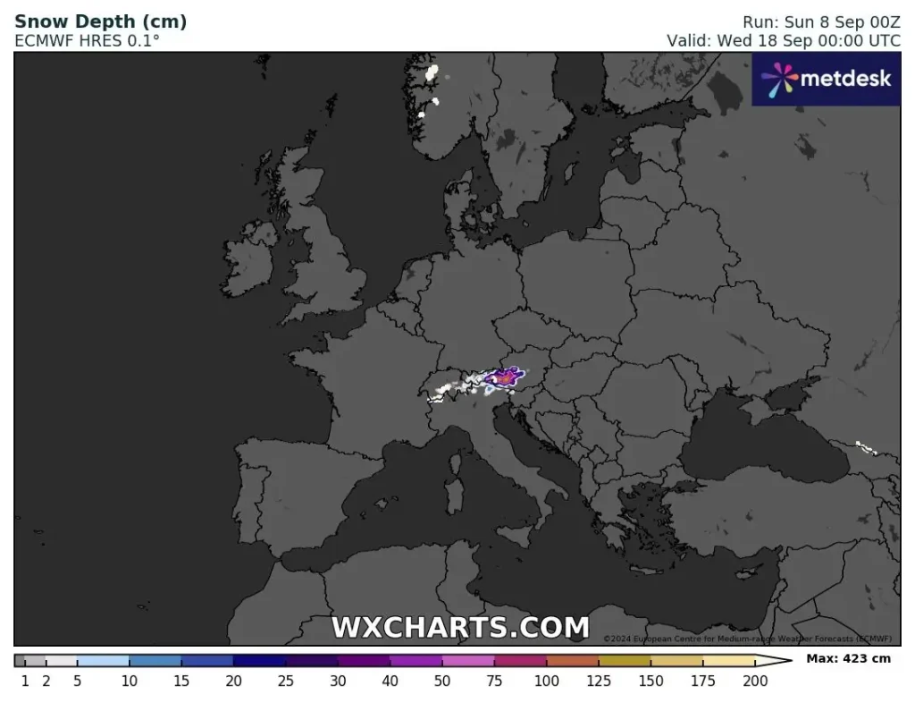
The influx of colder air could also result in snowfall in the higher elevations of the Alps, with up to 100 cm (39.4 inches) of snow possible in some areas, including Switzerland, Austria, and parts of northern Italy and northwestern Slovenia. The snow will primarily fall at altitudes above 2 000 m (6 562 feet), with the potential for significant accumulation in the coming days.
Snowfall projections for the Alps suggest that significant accumulations are likely, particularly in higher elevations. Snow depths of over 100 cm (39.4 inches) are possible in parts of the Swiss, Austrian, and Italian Alps, creating potentially dangerous conditions in mountain passes and ski resorts.
One unusual aspect of the current weather setup is the tropical wave affecting the western Sahara Desert. The Inter-Tropical Convergence Zone (ITCZ) has shifted northward, pushing tropical waves, which usually move westward into the Atlantic, into the Sahara.
This rare occurrence is expected to bring significant rainfall to one of the driest places on Earth. Some parts of the desert could receive up to 500% of their normal September rainfall, with certain areas likely to experience a greening effect after this event.
This tropical wave, combined with the upper low over western Europe, will direct warm and moist air into the northern Mediterranean and central Europe, increasing the risk of severe weather.
Residents of affected areas, particularly in northern Italy, Slovenia, Austria, and parts of the Balkans, should remain vigilant as these weather systems unfold.
References:
1 Mediterranean marine heatwave forecast to result in massive autumn rainfall across central Europe through mid-September – Severe Weather Europe – September 7, 2024

I am an Assistant Editor and Severe Weather & Science Journalist at The Watchers, specializing in real-time severe weather coverage, geophysical event reporting, and research-driven scientific analysis. You can reach me at rishav(at)watchers(.)news.
Commenting rules and guidelines
We value the thoughts and opinions of our readers and welcome healthy discussions on our website. In order to maintain a respectful and positive community, we ask that all commenters follow these rules.