
Violent storms hit southeast France, Marseille endures worst storm in 3 years
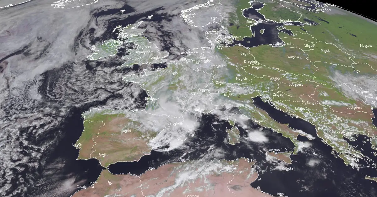
Image credit: EUMETSAT/Meteosat-11, RAMMB/CIRA, The Watchers. Acquired at 12:15 UTC on September 5, 2024
Severe storms swept across southeastern France on the night of September 4, 2024, bringing heavy rainfall, flooding, and powerful winds that disrupted transportation and caused evacuations in parts of the Alpes-Maritimes. Marseille, in particular, experienced its strongest storm in three years, with rain totals reaching nearly 150 mm (5.9 inches) in some areas.
Severe storms hit the southeast of France overnight on September 4, particularly affecting the Mediterranean coastline. Parts of the Alpes-Maritimes department saw nearly 150 mm (5.9 inches) of rainfall within 24 hours.
The storms, which impacted areas from Nice to Marseille, caused significant flooding, especially in Marseille, which experienced its most powerful storm in at least three years.
In Marseille, the floods severely disrupted the transport network, submerging several roads. In other areas, such as Mandelieu-la-Napoule in the Alpes-Maritimes, rainfall continued until early on September 5. The storms moved across the southeastern coastline, though cities like Nice and Toulon avoided major damage.
Les rues du port à #Marseille #inondation pic.twitter.com/NFIJt49ndl
— la chouette (@la_chouet) September 4, 2024
Nearly 100 mm (4 inches) of rainfall has been recorded between La Cayolle and Sormiou.
50 to 70 mm ( 1.9 to 2.7 inches) in the city center in 1 hour and 30 minutes. For Marseille, this is the biggest storm since 2021.
Inondation en cours sur Marseille suite à l'orage toujours en cours.
— Paul Marquis (Expert Meteo) (@La_Meteo_du_13) September 4, 2024
On relève parfois près de 100mm entre la Cayolle et Sormiou. 50 à 70mm en centre ville en 1H30.
Il s'agit du plus gros orage depuis Octobre 2021 sur la cité Phocéenne.
© Coralie et Cyril pour La Météodu13 pic.twitter.com/qbf1NV9FdB
The weather station in Vaudran recorded 55 mm (2.1 inches) of rain leading to severe flooding:
| Flood Alert: #Marseille, #France
— Weather monitor (@Weathermonitors) September 4, 2024
*More visuals of #HeavyRain causes flooding in Marseille
*Date: September 4, 2024
Stay safe and stay informed!#orages | #Flood | #inondation https://t.co/7KNyyDy34C pic.twitter.com/XyZqSu2jZu
In the Var department, emergency services responded to 18 incidents overnight, a relatively low number compared to previous storms this year. In rural areas of the Alpes-Maritimes, some residents in Alpine valleys were evacuated as a precaution. However, no major damage was reported.
Striking visuals of the storms were captured along the coastline:
Jeudi 15 août 2024, la saison des orages débute en Méditerranée. Voici quelques images de l'orage qui a balayé la #cotedazur cette nuit, vu depuis la corniche, près de #nice #orage #orages @KeraunosObs #StormHour pic.twitter.com/QeFDakWdEk
— Christophe Suarez (@suarezphoto) August 15, 2024
Cette nuit, un bel épisode méditerranéen.
— Kate Jacqueline Suarez (@KateSuarez8374) September 5, 2024
Les orages ont été stationnaires principalement sur Fréjus-St Raphaël pendant plusieurs heures pour enfin se décaler vers Nice d'où j'ai pris ces quelques photos.#cotedazurfrance #meteo #orages #Nice pic.twitter.com/Gb2bLyJWFT
Central France remained under heightened alert for flash flooding and heavy rain on September 5 following the violent storms from the previous night. Several departments, including Yonne, Nièvre, Allier, Saône-et-Loire, Puy-de-Dôme, Loire, and Haute-Loire, are under tier-three orange warnings, the second-highest level. These warnings were expected to remain in place until early afternoon, at which point they may be downgraded to tier-two alerts.
Rainfall across these regions could reach up to 50 mm (1.97 inches), which is equivalent to one month’s average September rainfall in some areas. Locally, rainfall amounts are forecast to be between 80 mm (3.15 inches) and 100 mm (3.94 inches).
The heavy rain is expected to move from central France toward Paris, continuing through Normandy and reaching the English Channel. In coastal Normandy, rain is predicted to continue overnight, while it is expected to cease earlier in Paris.
In the southwest, tier-two warnings are in place for potential river flooding after last night’s intense rainfall.
In the southeast, the Paca region (Provence-Alpes-Côte-d’Azur) is forecast to experience more storms, following the violent weather on the night of September 4. In Mandelieu-la-Napoule, 145 mm (5.71 inches) of rain fell within 24 hours, and additional rainfall is expected. Up to 10 mm (0.39 inches) of rain per hour may fall in the area On September 5, as storms continue to develop.
@VigiMeteofrance 05 septembre
— VigiMétéoFrance (@VigiMeteoFrance) September 5, 2024
Pour jeudi 05 septembre 2024 :
7 départements en Vigilance orange
Pour vendredi 06 septembre 2024 :
Restez prudents et informés :https://t.co/JGz4rTUvHP pic.twitter.com/pjXV6LtvI0
Mistral winds are also forecast to affect parts of the southern coastline, particularly around Perpignan, with gusts expected to exceed 80 km/h (49.7 mph).
The national weather service, Météo France, has indicated that the intensity of weather warnings may be updated throughout the day due to the ongoing instability.
References:
1 Dramatic scenes as violent storms hit southern France – CX – September 5, 2024
2 Flood warnings continue in central France after storms hit overnight – CX– September 5, 2024
3 France: Heavy Rains Flood Roads In Marseille – MSN -September 5, 2024

I am an Assistant Editor and Severe Weather & Science Journalist at The Watchers, specializing in real-time severe weather coverage, geophysical event reporting, and research-driven scientific analysis. You can reach me at rishav(at)watchers(.)news.
Commenting rules and guidelines
We value the thoughts and opinions of our readers and welcome healthy discussions on our website. In order to maintain a respectful and positive community, we ask that all commenters follow these rules.