
Hurricane warnings issued for Atlantic Canada, significant impacts from high winds, storm surge, and heavy rainfall are likely
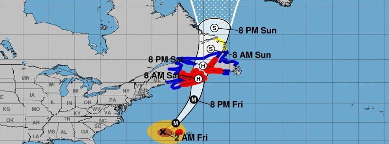
Image credit: Hurricane "Fiona" forecast track by NHC issued at 06:00 UTC on September 23, 2022
Fiona is expected to affect portions of Atlantic Canada as a powerful hurricane-force cyclone late Friday and Saturday, September 23 and 24, 2022, and significant impacts from high winds, storm surge, and heavy rainfall are likely, the National Hurricane Center (NHC) warns. Hurricane and Tropical Storm Warnings have now been issued for much of Atlantic Canada.
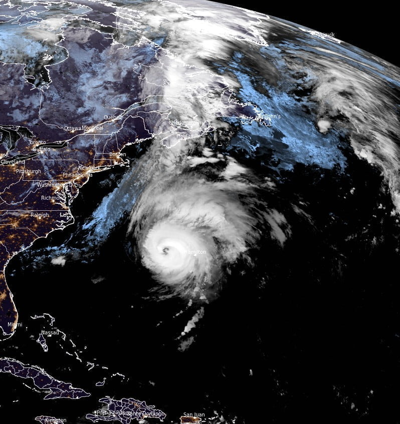
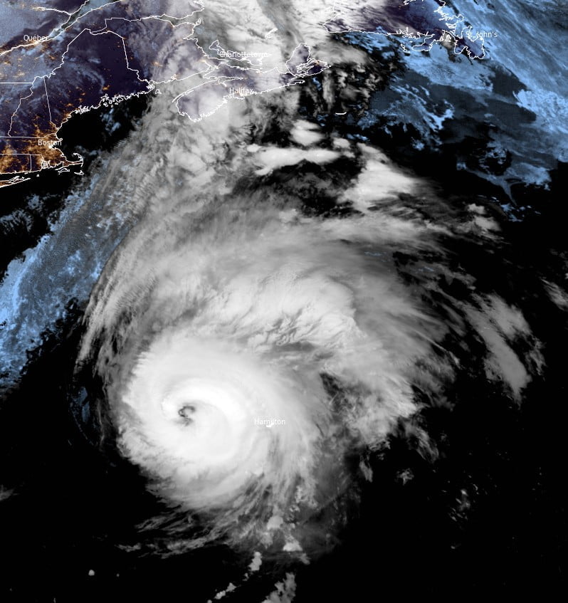
At 06:00 UTC on September 23, the center of Category 4 Hurricane “Fiona” was located about 300 km (185 miles) W of Bermuda and 1 410 km (875 miles) SSW of Halifax, Nova Scotia, Canada.1
Fiona’s maximum sustained winds were 215 km/h (130 mph) and minimum central pressure 935 hPa.
The system was moving NNE at 33 km/h (21 mph).
A north-northeast or northeastward motion with an increase in forward speed is expected today.
Some reduction in forward speed with a turn toward the north is forecast tonight through Sunday, September 25.
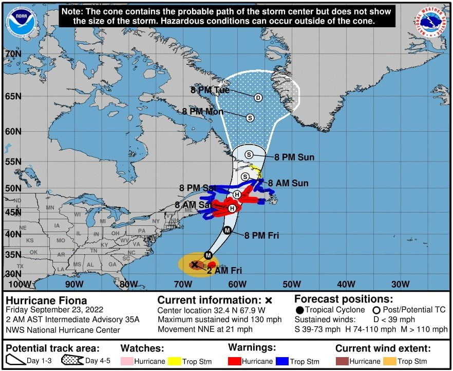
A Tropical Storm Warning is in effect for St. Andrews New Brunswick to west of Hubbards Nova Scotia, West of Brule Nova Scotia to Cap Madeleine Quebec, Anticosti Island, Sheldrake Quebec to north of Parson’s Pond Newfoundland, Boat Harbor to Hare Bay Newfoundland, Francois to St Lawrence Newfoundland.
A Tropical Storm Watch is in effect for areas north of Boat Harbor Newfoundland to West Bay Labrador.
On the forecast track, the center of Fiona will pass just to the west of Bermuda during the next several hours.
It will then approach Nova Scotia later today, move across Nova Scotia and into the Gulf of St. Lawrence on Saturday, and then across Labrador over the Labrador Sea on Sunday.
Some slight weakening is forecast to begin later today, however, Fiona is forecast to be a large and powerful post-tropical cyclone with hurricane-force winds when it approaches and moves over Nova Scotia tonight and Saturday.
This is currently a large tropical cyclone, with hurricane-force winds extending outward up to 185 km (115 miles) from the center and tropical-storm-force winds extending outward up to 445 km (275 miles).
Elevated automated stations on Bermuda are reporting sustained winds between 95-105 km/h (60-65 mph), with a maximum wind gust of 128 km/h (79 mph).
Hurricane conditions in Bermuda should diminish below tropical storm force during the day on Friday.
Large swells generated by Fiona are expected to cause life-threatening surf and rip current conditions along much of the east coast of the United States, the Bahamas, Bermuda, and Atlantic Canada during the next few days.
References:
1 Hurricane Fiona Intermediate Advisory Number 35A – NWS National Hurricane Center Miami FL – 200 AM AST Fri Sep 23 2022
I'm a dedicated researcher, journalist, and editor at The Watchers. With over 20 years of experience in the media industry, I specialize in hard science news, focusing on extreme weather, seismic and volcanic activity, space weather, and astronomy, including near-Earth objects and planetary defense strategies. You can reach me at teo /at/ watchers.news.
Commenting rules and guidelines
We value the thoughts and opinions of our readers and welcome healthy discussions on our website. In order to maintain a respectful and positive community, we ask that all commenters follow these rules.