
Multiple landslides hit Gisborne, two large slides in Southern Alps, New Zealand
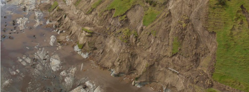
Featured image: Landslide triggered by heavy rain in East Cape, New Zealand - February 2022. Credit: Dr. Murry Cave
Heavy rainfall brought by the passage of Ex-Tropical Cyclone "Dovi" caused numerous landslides in New Zealand, some of which were notably large.
The southern end of the East Cape Road sustained serious damage in the heavy rain, and it may be two or three weeks before the road to the East Cape Lighthouse is reopened, Gisborne Herald reports.1
Five homes remain cut off from the rest of the country, and some of the people living there had to be choppered out.
From February 6 to 8, 2022, East Cape registered a total of 298.5 mm (11.7 inches) of rain. Of that amount, 171 mm (6.7 inches) fell in 12 hours, 153 mm (6 inches) in 6 hours and 111 mm (4.3 inches) in just 3 hours. Hourly rates were as high as 45 mm (1.7 inches).
The landslides that hit East Cape would probably be characterized as disrupted slides of earth, rock and debris, said Dr. Dave Petley of The Landslide Blog who received excellent images from Dr. Murry Cave, the Principal Scientist at Gisborne District Council.2
"Most appear to originate in the soil/regolith cover on these very steep slopes. On the lower slopes, the width of the failures is much higher. Note that the hills in the background have not suffered landslides to this degree, suggesting that this was driven by a highly localized rainfall event and/or by a local geological factor."
The passage of Cyclone Dovi from 6 to 8 February triggered multiple landslides at East Cape in Gisborne District, New Zealand:- https://t.co/qibNqihW9b Images by Dr Murry Cave. pic.twitter.com/PFINNjPy3n
— Dave Petley (@davepetley) February 15, 2022
Substantial rainfall was also recorded in New Zealand's Southern Alps in recent weeks, including 1 177 mm (46.3 inches) in just three days at Tuke Hut in Westland. As a result, two large landslides have occurred there.
One of these events occurred on the east face of Mount Tasman, which is the second-highest peak in New Zealand.
This landslide has a rock volume of about 169 000 m3 (5.9 million feet3), with a runout distance of 1 800 m (5 900 feet) and a fall height of 750 m (2 460 feet).
Another large slide took place at Beatrice in the Hooker Valley
"The Matiriki Project team had identified the source as a creeping landslide, which duly collapsed," Petley said.3, 4
"This might be interesting to look at using InSAR. This is a rather larger failure – the estimated volume is 704 000 m3 (25 million feet3), with a runout distance of 1 020 m (3 340 feet) and a vertical height change of 435 m (1 427 feet)."
References:
1 Strong rains hit East Cape roads – Gisborne Herald
2 Multiple landslides at East Cape in Gisborne District, New Zealand – The Landslide Blog
3 Two new large landslides in the Southern Alps of New Zealand – The Landslide Blog
4 MT TASMAN ROCK AVALANCHE, AORAKI MOUNT COOK NATIONAL PARK, FEBRUARY 2022 – Our Changing Landscape
The Watchers team and our contributors bring the latest on extreme weather, earthquakes, volcanic eruptions, space weather, and all things science. We're all about making sense of the natural world and keeping you informed on what’s happening. Got a tip or a question? Hit us up using the form at newstips!
Commenting rules and guidelines
We value the thoughts and opinions of our readers and welcome healthy discussions on our website. In order to maintain a respectful and positive community, we ask that all commenters follow these rules.