
Thousands of buildings in Auckland unsafe for living after worst rains in 170 years, New Zealand

Image credit: NIWA
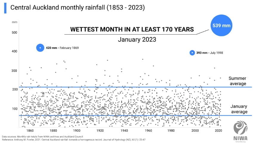
Thousands of buildings in New Zealand’s Auckland area are currently unsafe for living after the region was hit by extreme rainfall and severe flooding at the end of January. The amount of rain that fell in a matter of days made January 2023 Auckland’s wettest month in at least the last 170 years. The flooding has put the public’s focus on nature-based alternatives to traditional stormwater systems.
The presence of a low level jet, or strong wind in the lower atmosphere, combined with tropical moisture to create persistent heavy rain in the Auckland area on Friday, January 27, 2023, resulting in widespread severe flooding, destruction and 4 fatalities. Auckland officials described it as a devastating rain event, culminating in the declaration of a state of emergency.1
For many locations in Auckland, it was their wettest day on record — receiving approximately an entire summer’s worth of rain in one day.
The weather station located at Auckland Airport recorded 245 mm (9.65 inches) of rain, surpassing the previous record of 161.8 mm (6.37 inches) by over 50%. On the same day, Auckland’s Albert Park was drenched with 280 mm (11 inches) of rain in under 24 hours and 211 mm (8.3 inches) in under 6 hours.
Other weather stations around the region also reported remarkable rainfall, with many spots noting between 250 – 300 mm (9.84 – 11.81 inches) of rain within the day. Some stations even reported over 80 mm (3.15 inches) of rain in an hour.
To put this into context, the highest classification for intense rain at New Zealand’s MetService is ‘torrential’, which is defined as 40 mm (1.57 inches) of rain or more in an hour.
Heavy rains continued through the end of January and into February, breaking Auckland’s previous wettest month on record by far.
The new monthly record now stands at 539 mm (21.2 inches). The weather records there date back to 1853.
Honorary Associate Professor Anthony Fowler from the School of Environment at the University of Auckland said that nothing in the observational record has come close to what they’ve seen in the past few weeks.
“Total January rainfall was more than twice the previous record for the month, contributing to an exceptionally wet summer and the wettest three months on record. It was already a very wet January before the storm on the 27th, but that single event doubled the total over a single day. Rainfall intensities in the early evening, at the height of the storm, were quite astounding.”2
In total, Central Auckland experienced over 45% of its yearly rainfall in just one month, where the annual average is 1 190 mm (46.8 inches). This is over 8.5 times that of a typical January and over 2.5 times of an entire summer.
The rain across northern New Zealand has resulted in extensive damage due to widespread flooding on January 27, which the country’s National Institute of Water and Atmospheric Research (NIWA) describes as at least a 1-in-200-year event.
Four people have lost their lives and many hundreds have been displaced, with dozens of properties destroyed. Flights ground to a halt after Auckland International Airport was flooded and had to close, leaving thousands stranded abroad, some not able to get flights back for weeks.
NIWA Urban Aquatic Scientist Dr. Annette Semadeni-Davies says Auckland’s flooding has put the public’s focus on nature-based alternatives to traditional stormwater systems.
“Many parts of the network are aging and under increasing pressure from continued urbanisation and greater rainfall intensity. Nature-based solutions, such as infiltration basins, ponds and wetlands, have been put forward as additions to our current pipe-based systems for flood protection. However, these alone won’t be enough. We also need to explore low-risk infrastructure that diverts and stores water more effectively, introduce managed retreat for vulnerable areas, and continued maintenance and upgrades to our existing drain network.”
As of February 8, 277 buildings are labeled with red stickers — the building is unsafe and has sustained moderate or heavy damage, 1 615 with yellow stickers — access is restricted due to moderate damage, and 2 566 with white stickers — the building has suffered light damage and can be accessed.
Auckland Emergency Management is urging people to check on their neighbors and to watch for potential scammers in the wake of the flooding.3
Emergency controller Rachel Kelleher said today there are still large amounts of flood-damaged items to be collected.
“Our teams are working at pace to get these items collected as quickly as possible, and we thank everyone for their patience at this time,” she said.
Those who were unable to take waste to a transfer station could leave flood-damaged items at the kerbside to be collected, but items should be secure and placed away from storm water drains.
“Any items that have been in contact with floodwaters will be contaminated and can pose serious health risks,” Kelleher said.
Kelleher urged residents to clean up what’s possible and prepare for possible severe weather this coming weekend, February 12.
New rounds of rain will be brought by the newly-formed Tropical Cyclone “Gabrielle.”
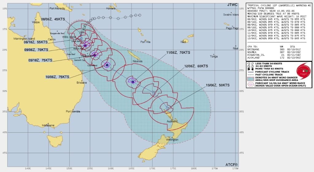
Gabrielle is expected to track southwest remaining over water, before re-curving towards the southeast on Thursday, putting it on a likely path towards New Zealand. It will continue on this track until it comes close to Northland late on Sunday, February 12 (LT).
“Although by the time it draws close to the top of the North Island it will have lost its tropical characteristics, it is still expected to be an intense weather system,“ New Zealand’s MetService meteorologist Mmathapelo Makgabutlane said.4
“Likely impacts of this system include heavy rain, gale force winds and large waves leading to dangerous coastal conditions for the upper North Island into early next week.”
There remains uncertainty around the exact path of Tropical Cyclone “Gabrielle” as it approaches New Zealand, and how things play out will be determined by what happens in the coming days.
References:
1 Extreme and unprecedented: Severe flooding hits Auckland after entire summer’s worth of rain in a single day, New Zealand – The Watchers – January 28, 2023
2 Auckland suffers wettest month in history – NIWA – February 2, 2023
3 Nearly 300 Auckland homes red stickered after floods, more bad weather expected – Stuff – February 8, 2023
4 Tropical Cyclone “Gabrielle” forms in the Coral Sea, forecast to rapidly intensify before moving toward New Zealand – The Watchers – February 8, 2023
I'm a dedicated researcher, journalist, and editor at The Watchers. With over 20 years of experience in the media industry, I specialize in hard science news, focusing on extreme weather, seismic and volcanic activity, space weather, and astronomy, including near-Earth objects and planetary defense strategies. You can reach me at teo /at/ watchers.news.
Commenting rules and guidelines
We value the thoughts and opinions of our readers and welcome healthy discussions on our website. In order to maintain a respectful and positive community, we ask that all commenters follow these rules.