
Eruption at Hunga Tonga-Hunga Ha’apai, Tonga
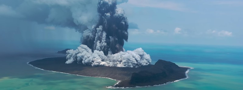
Image credit: Taniela Kula
Eruption at Hunga Tonga-Hunga Ha'apai volcano in Tonga started on December 19, 2021, and continued into 2022 although at a much lower intensity. The Aviation Color Code remains at Orange.
Intermittent eruption with an ash plume rising up to 3 km (10 000 feet) above sea level was reported by Wellington VAAC on January 1 and during the first half of January 2. At 12:21 UTC on January 2, the center announced there is no more evidence of eruption in satellite imagery.
In the first few days of the eruption, a massive gaseous cloud was rising to an estimated altitude of 18 km (59 000 feet) a.s.l., the island has grown up to 600 m (183 feet) to its eastern side and ash was falling within a 10 km (6.2 miles) radius.
Plumes became intermittent by December 24, rising to 10.4 km (34 000 feet) a.s.l. and occasionally as high as 12.2 km (40 000 feet) a.s.l.
Tonga Geological Services reported that on December 27 and 28 clouds of gas and steam drifted E across the ‘Otu Mu’omu’a Islands of Ha’apai at altitudes of 1 – 18 km (3 300-59 000 feet) a.s.l.1, 2
The agency warned residents to protect water reservoirs because rain may be acidic or contain traces of ash, though the plumes were predominantly drifting at high levels.
Stole this footage from my cuzn of Hunga Tonga & Hunga Ha’apai where an undersea volcano erupted on Sunday night. pic.twitter.com/4ED8mpxmwk
— Alakihihifo Vailala (@alakihihifo) December 22, 2021
Data from the @CopernicusEU's Sentinel-1 mission shows that the island of Hunga Tonga has grown larger because of this eruption.
Look at the new bright area in the middle of this, that's new land! https://t.co/iswrCaJMpX pic.twitter.com/LJtoTaSgxF— Simon Proud (@simon_sat) December 24, 2021
Impressive comparison of two images of #HungaTongaHungaHaapai captured by #Copernicus #Sentinel2 true color on Dec. 3th and Jan. 2. #Tonga #volcano #eruption #Tongaeruption @CultureVolcan @gnsscience @andreabettini pic.twitter.com/rofJJt9IHQ
— ADAM Platform (@PlatformAdam) January 3, 2022
A drone overflight on December 30 showed the amazing nature of the eruption:
Geological summary
The small islands of Hunga Tonga and Hunga Ha'apai cap a large seamount located about 30 km (18 miles) SSE of Falcon Island.
The two linear andesitic islands are about 2 km (1.2 miles) long and represent the western and northern remnants of the rim of a largely submarine caldera lying east and south of the islands.
Hunga Tonga and Hunga Ha'apai reach an elevation of only 149 m (488 feet) and 128 m (419 feet) above sea level, respectively, and display inward-facing sea cliffs with lava and tephra layers dipping gently away from the submarine caldera.
A rocky shoal 3.2 km (2 miles) SE of Hunga Ha'apai and 3 km (1.8 miles) south of Hunga Tonga marks the most prominent historically active vent. Several submarine eruptions have occurred at Hunga Tonga-Hunga Ha'apai since the first historical eruption in 1912.3
References:
1 Global Volcanism Program, 2021. Report on Hunga Tonga-Hunga Ha'apai (Tonga). In: Sennert, S K (ed.), Weekly Volcanic Activity Report, 22 December-28 December 2021. Smithsonian Institution and US Geological Survey.
2 Acid rain warning for Tonga after massive eruption at Hunga Tonga-Hunga Ha'apai – The Watchers
3 Hunga Tonga-Hunga Ha'apai – Geological summary – GVP
I'm a dedicated researcher, journalist, and editor at The Watchers. With over 20 years of experience in the media industry, I specialize in hard science news, focusing on extreme weather, seismic and volcanic activity, space weather, and astronomy, including near-Earth objects and planetary defense strategies. You can reach me at teo /at/ watchers.news.
Commenting rules and guidelines
We value the thoughts and opinions of our readers and welcome healthy discussions on our website. In order to maintain a respectful and positive community, we ask that all commenters follow these rules.