
Eruption at Home Reef volcano drives significant lava lobe growth, Tonga
The formation of 75 000 m2 (807 300 feet2) lava lobe has been observed at the Home Reef volcano between December 4 and 15, 2024.

Satellite image of Home Reef volcano captured on December 17, 2024. The image showcases enhanced natural color visualization with prominent lava flows and new growth along the northeastern shore. Image credit: Copernicus EU/Sentinel-2, EO Browser, The Watchers
Tonga Geological Services reported that satellite imagery captured on December 15 confirmed a new lava lobe covering approximately 75 000 m2 (807 300 feet2). The development occurred between December 4 and December 15 with small explosions and persistent effusion of mafic lava.
Thermal activity at the volcano was first observed at 01:15 LT (12:15 UTC) on December 4 through satellite monitoring. Since then, the volcanic radiative power (VRP) on the Middle Infrared Observation of Volcanic Activity (MIROVA) scale has remained at moderate to low levels.
Sentinel-2 imagery from December 7 and 12 indicated an additional 1 000 m2 (10 764 feet2) of growth on the island during this period.

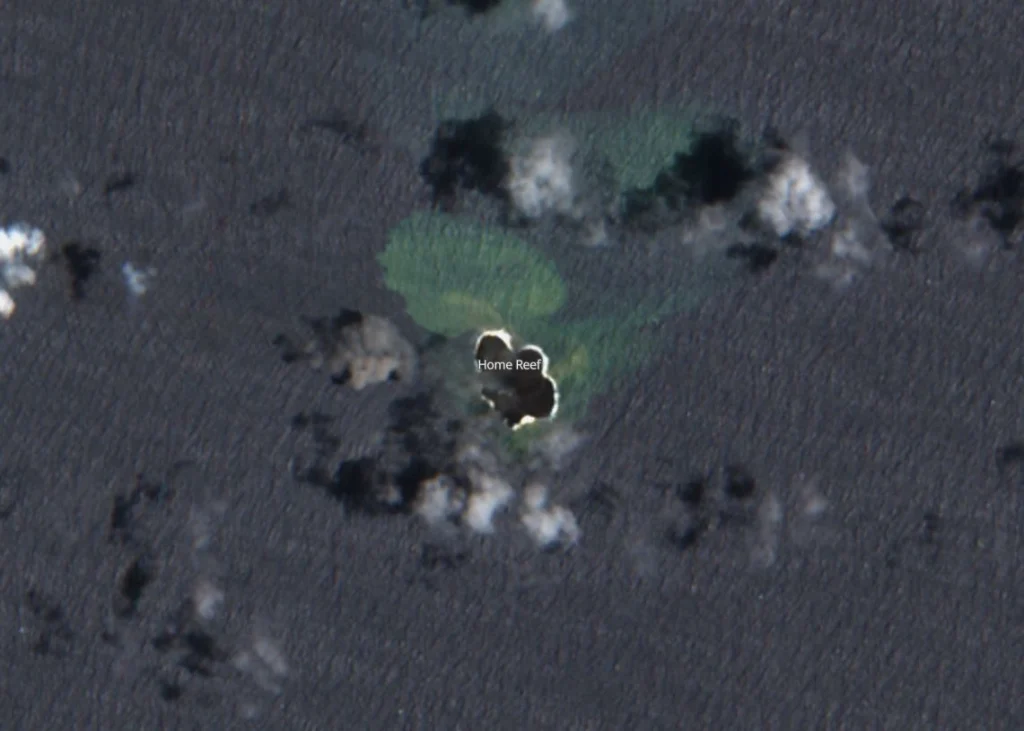
The most recent imagery was captured on December 15, revealing gray-colored clouds presumed to be ash-rich near the island along with a long line of vapor. No major explosive eruptions have been observed despite these indicators.


Authorities have issued multiple public notices addressing the ongoing volcanic activity. Mariners are advised to maintain a safe distance of at least 3.7 km (2.3 miles) from the volcano.
The volcanic activity poses a low risk to nearby communities in Vava’u and Ha’apai with a Green Terrestrial Color Code issued for residents and a Yellow Aviation Color Code.
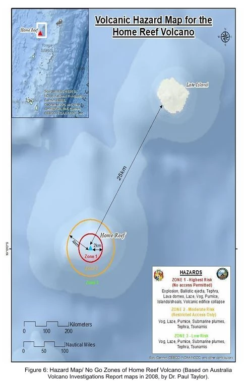
The Home Reef volcano is situated between Metis Shoal and Late Island in the central Tonga Islands. It lies approximately 25 km (15.5 miles) southwest of Late Island, 22 km (13.7 miles) northeast of Lateiki (Metis Shoal), and 75 km (46.6 miles) northwest of Mo’unga’one Island.
The volcano is a part of the Tofua Volcanic Arc and is well-known for its frequent eruptions, often resulting in the formation of temporary islands.

Home Reef experienced its first eruptive phase of 2024 from June 10 to July 4. During this period, strong thermal anomalies were reported on June 14, 20, 25, and 30. The activity transitioned to irregular hotspots by July 5 and eventually subsided by the end of August.
A more important eruption occurred in 2022, with a Volcanic Explosivity Index (VEI) of 2. The event formed a temporary island and generated dacitic pumice rafts that traveled across the Pacific Ocean and reached Australia.
Similar activity was recorded in August 2006 and March 1984 with VEI 2 and VEI 3 eruptions and produced pumice rafts and temporary land formations.
References:
1 Home Reef – GVP – Accessed on December 24, 2024
2 Home Reef Volcano grows new lava lobe, with ongoing activity – Matangi Tonga Online – December 23, 2024

Rishika holds a Master’s in International Studies from Stella Maris College, Chennai, India, where she earned a gold medal, and an MCA from the University of Mysore, Karnataka, India. Previously, she served as a Research Assistant at the National Institute of Advanced Studies, Indian Institute of Science, Bengaluru, India. During her tenure, she contributed as a Junior Writer for Europe Monitor on the Global Politics website and as an Assistant Editor for The World This Week. Her work has also been published in The Hindu newspaper, showing her expertise in global affairs. Rishika is also a recipient of the Women Empowerment Award at the district level in Haryana, India, in 2022.
Throughout Earth’s history the final stage of geomagnetic reversal was accompanied with the massive eruption of volcanoes, both land based volcanoes and the submarine volcanoes. In fact, large amount of data show that extinction of the dansoirs was caused by the massive eruption of volcanoes that also triggered global wildfires
The geological upheaval is underway, due to the rapid pole shift
The rate of earthquakes and volcanic activity is continuous and stable. The magnetosphere does not effect terrestrial geology and has no effect on the climate. An actual magnetic reversal could wreak havoc on satellites and mildly increase chances of sunburn. A reversal during a solar maximum might also evoke dramatic aurora.