
Hunga Tonga–Hunga Haʻapai eruption created the highest volcanic cloud ever recorded
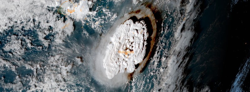
Featured image: Eruption at Hunga Tonga-Hunga Ha'apai volcano, Tonga at 05:10 UTC on January 15, 2022. Credit: JMA/Himawari-8, RAMMB/CIRA, The Watchers
A new analysis published in Science shows the eruption at Hunga Tonga–Hunga Haʻapai volcano in Tonga on January 15, 2022, created the highest volcanic cloud ever recorded. This is the first time a volcanic plume has been seen to penetrate the stratopause.
The researchers led by Simon Proud, a National Centre for Earth Observation senior scientist at the University of Oxford and the Science and Technology Facilities Council’s RAL Space facility, used geostationary satellite images of the eruption to show that its volcanic cloud reached an altitude of 57 km (35.4 miles / 187 000 feet) above sea level at its highest extent.1
This places the plume in the lower mesosphere and provides observational evidence of a volcanic eruption injecting material through the stratosphere and directly into the mesosphere.
The mesosphere reaches between approximately 48 km and 80 km (30 – 50 miles) high and is the third layer of the atmosphere, above the troposphere and the stratosphere. Meteors falling to earth often burn up in the mesosphere, causing shooting stars in the night sky. It is the coldest part of Earth’s atmosphere, with temperatures near the top reaching as low as -143 °C (-225.4 °F).2
In the study, the authors discuss the potential implications of this injection and suggest that the altitude reached by plumes from previous eruptions, such as the eruption of Mount Pinatubo in 1991, may have been underestimated because of a lack of observational data.
The height of Mount Pinatubo volcanic plume is estimated at 40 km (131 200 feet) a.s.l.
“It’s the first time we’ve ever recorded a volcanic plume reaching the mesosphere. Krakatau in the 1800s might have done as well, but we didn’t see that in enough detail to confirm,’ said Proud.
Normally, the height of a volcanic plume can be estimated by measuring the temperature at its top and comparing it to the standard air temperatures found at various altitudes. This is because, in the troposphere, the lowest layer of the Earth’s atmosphere, temperature decreases with height.
But, if the eruption is so large the plume penetrates the higher layers of the atmosphere, this method becomes unreliable, as air temperatures begin to increase again with height. To overcome this problem, the researchers developed a technique based on a phenomenon called ‘the parallax effect’.
The location of the Tonga volcano is covered by three geostationary weather satellites, 36 000 km (22 360 miles) up in space, so the researchers were able to apply the parallax effect to the aerial images these captured. Crucially, during the eruption itself, the satellites recorded images every 10 minutes, enabling the rapid changes in the plume’s trajectory to be documented.
“Thirty years ago, when Pinatubo erupted, our satellites were nowhere near as good as they are now. They could only scan the earth every 30 minutes. Or maybe even every hour,’ said Dr. Proud.
“We think for Pinatubo we actually missed the peak of the activity and the points where it went the highest: it fell between two of the satellite images and we missed it. In reality, it probably went quite a bit higher than the estimates that we have for its height.”
“The interesting thing is, this eruption put a lot of water into the mesosphere, which is usually a very dry part of the atmosphere,” Proud said. “This makes the eruption a useful test case for how well our climate and weather models can cope with unexpected and extreme conditions.”
The researchers now intend to construct an automated system to compute the heights of volcano plumes using the parallax method.

Note: The image was recorded one day before the major eruption.
The Tonga eruption took place under the sea, around 65 km (40 miles) from the country’s main island, causing tsunamis felt as far away as Russia, the United States, and Chile. The waves claimed six lives, including two people in Peru, 10 000 km (6 200 miles) away.
References:
1 The January 2022 eruption of Hunga Tonga-Hunga Ha’apai volcano reached the mesosphere – Proud et al. – Science – November 3, 2022 – DOI: 10.1126/science.abo4076
2 Tonga volcano had highest plume ever recorded, new study confirms – University of Oxford – November 4, 2022
I'm a dedicated researcher, journalist, and editor at The Watchers. With over 20 years of experience in the media industry, I specialize in hard science news, focusing on extreme weather, seismic and volcanic activity, space weather, and astronomy, including near-Earth objects and planetary defense strategies. You can reach me at teo /at/ watchers.news.
Commenting rules and guidelines
We value the thoughts and opinions of our readers and welcome healthy discussions on our website. In order to maintain a respectful and positive community, we ask that all commenters follow these rules.