
Acid rain warning for Tonga after massive eruption at Hunga Tonga-Hunga Ha’apai
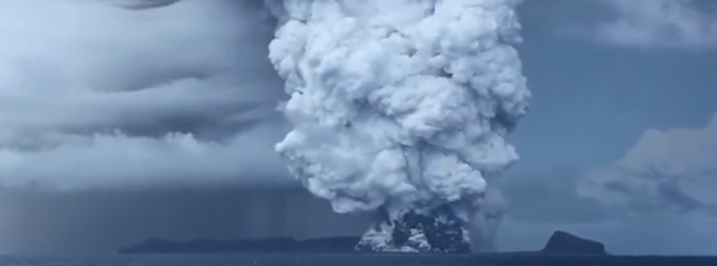
Image credit: Alakihihifo Vailala (stillshot). Acquired on December 22, 2021
Massive gaseous cloud produced by the eruption at Hunga Tonga-Hunga Ha'apai volcano in Tonga rose to an estimated altitude of 18 km (59 000 feet) above sea level, prompting Tonga Geological Services (TGS) to warn all citizens and tourists of possible acid rain in the region. The volcano is located about 65 km (40 miles) NW of the capital Nuku'alofa.
While there were no injures reported as a result of the eruption that started on December 191, TGS said late Tuesday, December 21 that the dust and gas could result in acidic rainfall if mixed with water in the atmosphere, potentially poisoning drinking water and damaging skin and eyes.
"Symptoms of exposure to acid rain are itchiness and skin irritation, blurry and discoloration of vision if exposed to the eye," TGS said. "If eyes or skin are exposed to acidic rain, please see a medical doctor or physician for appropriate treatment."2
Stole this footage from my cuzn of Hunga Tonga & Hunga Ha’apai where an undersea volcano erupted on Sunday night. pic.twitter.com/4ED8mpxmwk
— Alakihihifo Vailala (@alakihihifo) December 22, 2021
TGS Head Geologist Taniela Kula reported spectacular bursts of lightning at the top of the 18 km (59 000 feet) high cloud, seen from the capital and Kanokupolu coast after 15:30 UTC (19:30 LT) on December 21.
Kula said the eruption on December 19 initially reached an altitude of 3 – 16 km (9 800 – 52 500 feet) a.s.l. in a mushroom formation with a 30 km (18.5 miles) radius, and during the rest of the day reached 18 km over the 'Otu Mu'omu'a and 'Otumotu Lulunga of Ha'apai, as well as covering Tongatapu and 'Eua.3
At 12:40 UTC on December 20, the ash/dust eruption maintained an 18 km altitude and reached over the Vava’u Islands including Fonualei Island.
By 15:00 UTC, it reached Niuafo’ou Island and Niuatoputapu and Tafahi Islands by 17:00.
High resolution satellite image of the #HungaTongaHungaHaapai eruption captured by @Maxar satellite earlier today. It looks like the eruption is in the same spot as the 2014/2015 event. pic.twitter.com/SkwU50GXrA
— Murray Ford (@mfordNZ) December 22, 2021
On Dec 21 (local time in #Tonga), @NOAA #GOESWest/#GOES17 shows continued #eruptive activity at #Hunga Tonga-Hunga Ha'apai, with abundant #lightning in the #volcanic plume.
Data: #GOES GeoColor and Geostationary Lightning Mapper Group Energy Density products from @CIRA_CSU. pic.twitter.com/sxXAcvHD1J
— Prof. Simon Carn (@simoncarn) December 21, 2021
Ayer alrededor de las 14:30 hr (hora del centro de México) se registró una gran erupción en la isla volcánica "Hunga Tonga-Hunga Haʻapai" creando una columna de ceniza de más de 16 km de altura. #Hilo
Satélite meteorológico #GeoKompsat de Corea. pic.twitter.com/MNWfPo3P3q
— Alejandro S. Méndez (@asalmendez) December 20, 2021
#AlMomento
Erupción del volcán Hunga-Ha’apai ubicado en el archipiélago de #Tonga
La isla está deshabitada pero la erupción, durante las primeras horas del lunes, pudo verse en las islas cercanas gracias a que la columna eruptiva superó 15 km de altura. pic.twitter.com/WapDb5iKuz— GrajalesTV (@GrajalesTv) December 20, 2021
The last eruption of this volcano started on December 19, 2014, and ended on January 23 (± 3 days), 2015 (VEI 2).
The eruption created a new island — the site of this latest eruption.4
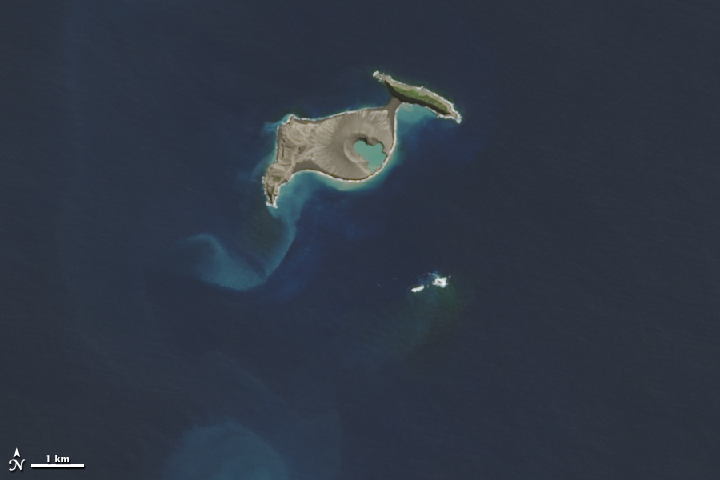
Image credit: NASA/USGS. Acquired April 28, 2015.
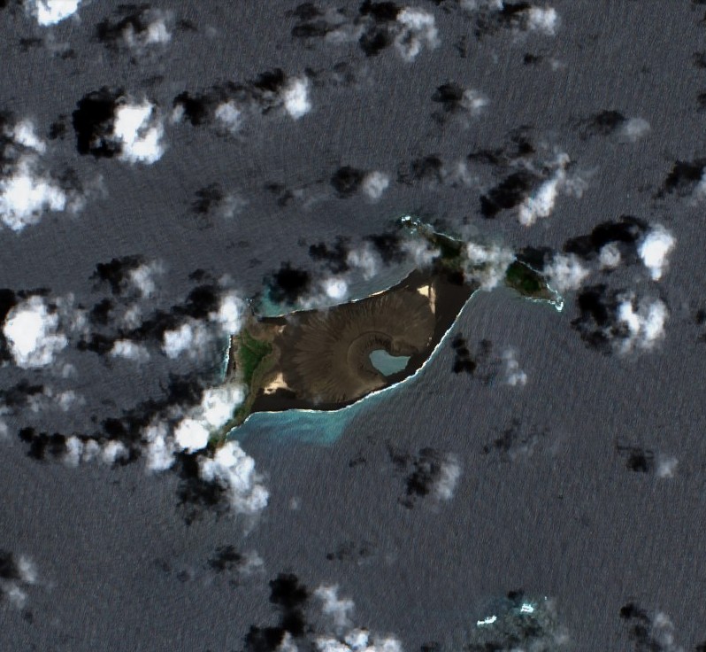
Hunga Tonga-Hunga Ha'apai on December 18, 2021. Credit: Copernicus EU/Sentinel-2, TW
Geological summary
The small islands of Hunga Tonga and Hunga Ha'apai cap a large seamount located about 30 km (18 miles) SSE of Falcon Island.
The two linear andesitic islands are about 2 km (1.2 miles) long and represent the western and northern remnants of the rim of a largely submarine caldera lying east and south of the islands.
Hunga Tonga and Hunga Ha'apai reach an elevation of only 149 m (488 feet) and 128 m (419 feet) above sea level, respectively, and display inward-facing sea cliffs with lava and tephra layers dipping gently away from the submarine caldera.
A rocky shoal 3.2 km (2 miles) SE of Hunga Ha'apai and 3 km (1.8 miles) south of Hunga Tonga marks the most prominent historically active vent.
Several submarine eruptions have occurred at Hunga Tonga-Hunga Ha'apai since the first historical eruption in 1912.5
References:
1 High-level eruption at Hunga Tonga-Hunga Ha'apai volcano, Tonga – The Watchers
2 Tongans warned of acid rain after volcanic eruption – CNA
3 Tongans told to protect water tanks from acid rain, as eruption continues – Matangi Tonga
4 New island being formed by Hunga Tonga-Hunga Ha'apai eruption – The Watchers
5 Hunga Tonga-Hunga Ha'apai – Geological summary – GVP
I'm a dedicated researcher, journalist, and editor at The Watchers. With over 20 years of experience in the media industry, I specialize in hard science news, focusing on extreme weather, seismic and volcanic activity, space weather, and astronomy, including near-Earth objects and planetary defense strategies. You can reach me at teo /at/ watchers.news.
Commenting rules and guidelines
We value the thoughts and opinions of our readers and welcome healthy discussions on our website. In order to maintain a respectful and positive community, we ask that all commenters follow these rules.