
Increased volcanic unrest at White Island, Alert Level raised to 2, New Zealand
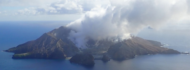
Image credit: GeoNet
Volcanic unrest has increased at Whakaari/White Island, with sustained greater heat flow and volcanic gas changes, prompting GeoNet to raise the Volcanic Alert Level to Level 2 and the Aviation Color Code to Yellow. There is still uncertainty about what is driving current activity at the volcano.
Persistent observations of night glow on the web cameras indicate continued emission of high-temperature gases, GeoNet reported in a bulletin released July 26, 2021.
Elevated levels of gas emissions continue but the ratio of carbon dioxide to sulfur dioxide has decreased. A more detailed evaluation of this observation supports the presence of magma at shallow depth.
Last week’s observation and thermal infrared (IR) measurement flight reported very hot gas (498 to 654 °C / 928 to 1 209 °F) being emitted from some of the vents on the 2019 lava extrusion.
The observation of night glow on web cameras has continued since June 30 and is ongoing.
Tremor and volcano-seismicity have remained low and ground deformation shows an overall pattern of subsidence, with some variability.
"There is still large uncertainty about the mechanisms driving the current activity," GeoNet said.
"Most scenarios are consistent with a slightly increased level of unrest at Whakaari/White Island and we have therefore raised the Volcanic Alert Level to 2 (moderate to heightened unrest) and the Aviation Colour Code to Yellow. There are no obvious signs of eruptive activity."
The Volcanic Alert Level reflects the current level of volcanic unrest or activity and is not a forecast of future activity.
While Volcanic Alert Level 2 is mostly associated with volcanic unrest hazards (including discharge of steam and hot volcanic gases, earthquakes, landslides and hydrothermal activity), potential for eruption hazards also exists and eruptions can still occur with little or no warning.
Geological summary
Uninhabited 2 x 2.4 km (1.2 x 1.5 miles) White Island, one of New Zealand's most active volcanoes, is the emergent summit of a 16 x 18 km (10 x 11.2 miles) submarine volcano in the Bay of Plenty about 50 km (31 miles) offshore of North Island.
The island consists of two overlapping andesitic-to-dacitic stratovolcanoes; the summit crater appears to be breached to the SE, because the shoreline corresponds to the level of several notches in the SE crater wall. Volckner Rocks, four sea stacks that are remnants of a lava dome, lie 5 km (3.1 miles) NNE.
Intermittent moderate phreatomagmatic and strombolian eruptions have occurred throughout the short historical period beginning in 1826, but its activity also forms a prominent part of Maori legends.
Formation of many new vents during the 19th and 20th centuries has produced rapid changes in crater floor topography. The collapse of the crater wall in 1914 produced a debris avalanche that buried buildings and workers at a sulfur-mining project. (GVP)
I'm a dedicated researcher, journalist, and editor at The Watchers. With over 20 years of experience in the media industry, I specialize in hard science news, focusing on extreme weather, seismic and volcanic activity, space weather, and astronomy, including near-Earth objects and planetary defense strategies. You can reach me at teo /at/ watchers.news.
Commenting rules and guidelines
We value the thoughts and opinions of our readers and welcome healthy discussions on our website. In order to maintain a respectful and positive community, we ask that all commenters follow these rules.