
Tropical Storm “Laura” wreaks havoc across the Dominican Republic, Haiti and Puerto Rico
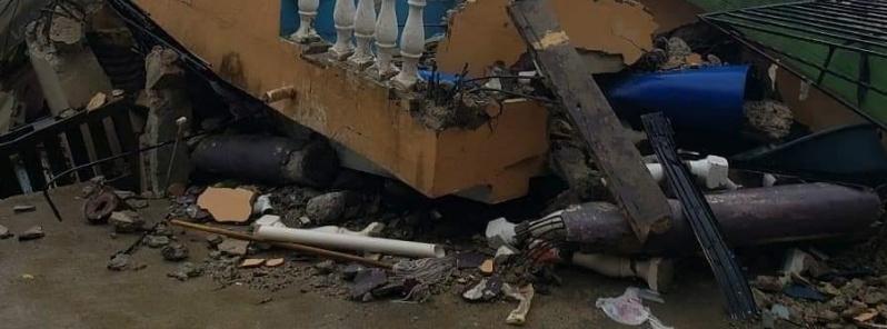
Image credit: CycloforumsPR
Tropical Storm "Laura" brought strong winds and heavy rain to Puerto Rico, the Dominican Republic, and Haiti over the weekend, August 22 into 23, 2020, leaving at least 11 people dead and more than 1 million without power. The storm is now dumping heavy rain over parts of Cuba and Jamaica.
Laura is moving toward the United States and is expected to strengthen into a hurricane by Tuesday, August 25. Another tropical storm — Marco — is already near the northern Gulf Coast, forcing officials so issue Hurricane and Storm Surge warnings.
Floods and landslides caused by Tropical Storm "Laura" left at least 11 people dead in the Dominican Republic and Haiti, with the death toll still expected to rise. Homes, vehicles, and roads were washed away in the region and more than 1 million people were left without power on Sunday, August 23.
In Santo Domingo, Dominican Republic's capital, floods destroyed several homes, forced the evacuation of more than 1 000 people, and isolated more than 120 communities.
[Tormenta Laura – Efectos en RD]
Muchas inundaciones urbanas como muestra este vídeo grabado anoche en la capital Santo Domingo. pic.twitter.com/Ct2YwssnLj— CycloforumsPR (@CycloforumsPR) August 23, 2020
[Tormenta Laura – Efectos en RD]
Las autoridades dominicanas contabilizan la magnitud de los daños a estructuras residenciales y comerciales. Al igual que en PR, muchos subestimaron el efecto de la tormenta, pero en Dominicana golpeó más fuerte. pic.twitter.com/GLe9cmLnHl— CycloforumsPR (@CycloforumsPR) August 23, 2020
[Tormenta Laura – Efectos en RD]
La trayectoria por el sur de la capital Santo Domingo se refleja en estas imágenes de daños causados en el Disgtrito Nacional y en Rosario de Azua. pic.twitter.com/g7mL1RsXpO— CycloforumsPR (@CycloforumsPR) August 23, 2020
[Tormenta Laura – Efectos en RD]
Daños causado por Laura en la carretera que conecta a Duvergé con Jimaní. La tercera foto es de Santo Domingo y muestra a varios ciudadanos cortando ramas y troncos de árboles derribados para despejar calles y carreteras. pic.twitter.com/YCyZjheR14— CycloforumsPR (@CycloforumsPR) August 23, 2020
Evacuations also took place in Haiti. The country's civil protection agency confirmed deaths of 5 people late Sunday, including 2 women, 2 men, and a 10-year-old girl.
#TTLaura: Anpil lapli gentan tonbe plizyè kote nan peyi, sitou nan Lwès ak nan Sidès.
Sonje : dlo k ap desann PA JWE‼️#SezonSiklòn2020 #Laura pic.twitter.com/y5MlBEFWL8
— Pwoteksyon sivil (@Pwoteksyonsivil) August 23, 2020
In Puerto Rico, strong winds and heavy rainfall left about 200 000 customers without power on Saturday night, August 22, and more than 10 000 without water.
Two people were reportedly trapped along the rapidly rising Toro Negro River. Puerto Rico Governor Wanda Vázquez declared a state of emergency and urged residents to stay inside until the threat is over.
#PuertoRico #TormentaLaura #Laura pic.twitter.com/bXjBDFl08C
— It's just me (@abdielcm311) August 22, 2020
Laura's center was about 100 km (62 miles) S of Camaguey, Cuba at 06:00 UTC today. It had maximum sustained winds of 100 km/h (62 mph) and was moving WNW at 33 km/h (21 mph). The system had minimum central pressure of 1 000 hPa.
The storm's center is forecast to move over the Caribbean Sea just offshore the southern coast of Cuba today, and move into the southeastern Gulf of Mexico tonight and Tuesday.
Laura is then forecast to move over the central and northwestern Gulf of Mexico Tuesday night and Wednesday.
The cyclone is expected to produce 100 – 200 mm (4 to 8 inches) of rain, with isolated amounts of 150 mm (6 inches), over Western Haiti, Jamaica, and Cuba. Cayman Islands: 50 – 100 mm (2 to 4 inches), with maximum amounts of 150 mm. Florida Keys, Turks and Caicos Islands, and the Northwest Bahamas: 25 – 50 mm (1 to 2 inches).
"Across the Greater Antilles, this heavy rainfall could lead to life-threatening flash and urban flooding, and the potential for mudslides," NHC forecaster Stewart warned.
From late Wednesday into Friday, Laura is expected to produce rainfall of 125 – 250 mm (5 to 10 inches), with isolated maximum amounts of 380 mm (15 inches) across portions of the west-central U.S. Gulf Coast near the Texas and Louisiana border north into portions of the lower Mississippi Valley.
This rainfall could cause widespread flash and urban flooding, small streams and tributaries to overflow their banks, and the possibility of some minor river flooding to this region.

A Tropical Storm Warning is in effect for:
– Little Cayman and Cayman Brac
– Cuban provinces of Camaguey, Las Tunas, Holguin, Guantanamo, Santiago de Cuba, Granma, Ciego De Avila, Sancti Spiritus, Villa Clara, Cienfuegos, Matanzas, Mayabeque, La Habana, Artemisa, Pinar del Rio, and the Isle of Youth
– Dry Tortugas
A Tropical Storm Watch is in effect for:
– Florida Keys from Craig Key to Key West
Tropical storm conditions are expected to spread westward within the warning area in Cuba through today, August 24.
Tropical storm conditions are expected in Little Cayman, Cayman Brac, and the Dry Tortugas today; possible within portions of the watch area in the Florida Keys today.
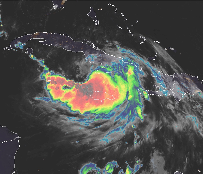
Tropical Storm "Laura" at 05:50 UTC on August 24, 2020. Credit: NOAA/GOES-East, RAMMB/CIRA
Swells generated by Laura are affecting portions of Hispaniola, eastern Cuba, the southeastern Bahamas, and the Turks and Caicos Islands.
These swells are expected to spread across central and western Cuba, the central and northwestern Bahamas, and the Florida Keys today.
An isolated tornado is possible across far southern Florida today.
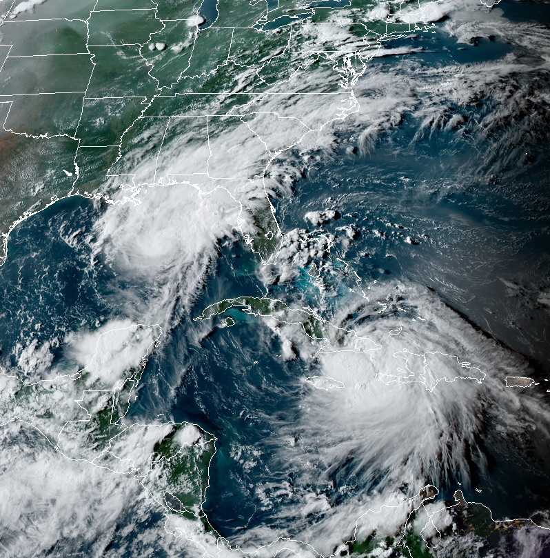
Tropical storms Marco (left) and Laura (right) at 22:00 UTC on August 23, 2020. Credit: NOAA/GOES-East, RAMMB/CIRA
Residents of the northern Gulf Coast, U.S. are already dealing with another tropical storm — Marco.
At 06:00 UTC on August 24, the center of Tropical Storm "Marco" was located about 240 km (150 miles) SSE of the Mouth of the Mississippi River. Its maximum sustained winds were 100 km/h (65 mph) and minimum central pressure 1 002 hPa. Marco is moving NNW at 19 km/h (12 mph).
Marco is forecast to approach the coast of Louisiana Monday afternoon (LT), and then turn westward and move near or over the coast through Tuesday, August 25, NHC forecasters said.
Fluctuations in intensity are forecast over the next 24 hours, but Marco is expected to weaken rapidly by early Tuesday (LT).
"It is worth noting that Marco is a small tropical cyclone," NHC forecaster Zelinsky noted.
"The large area of Tropical Storm and Hurricane watches and warnings along the northern Gulf Coast is a reflection of the unusually high uncertainty in the forecast, and it is unlikely that all of those regions will experience tropical-storm-force winds or life-threatening storm surge associated with Marco.
"However, impacts will likely occur in some portions of the watch/warning area beginning on Monday, and heavy rain is likely across most of the region during the next couple of days. Changes to the watches and warnings are likely on Monday and users should consult products from their local weather forecast office for more information about potential hazards in their area."

I'm a dedicated researcher, journalist, and editor at The Watchers. With over 20 years of experience in the media industry, I specialize in hard science news, focusing on extreme weather, seismic and volcanic activity, space weather, and astronomy, including near-Earth objects and planetary defense strategies. You can reach me at teo /at/ watchers.news.
Commenting rules and guidelines
We value the thoughts and opinions of our readers and welcome healthy discussions on our website. In order to maintain a respectful and positive community, we ask that all commenters follow these rules.