
Eruption continues at Sinabung volcano, Indonesia
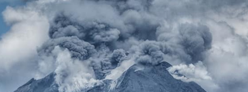
Featured image: Mount Sinabung on August 24, 2020. Credit: Nachelle Homestay
Volcanic eruptions continue at Sinabung volcano, Indonesia since August 7 after more than a year of inactivity. Authorities are urging residents and tourists to stay outside a 5 km (3.1 miles) radius from the crater. The Alert Level remains at III (Siaga/Alert).
On Sunday, August 23, volcanic ash rose up to 3.9 km (13 000 feet) above sea level, drifting northwest.
Pyroclastic flows produced on Sunday traveled about 1 km (0.62 miles) to the southeast.
Sinabung volcano is currently exhibiting volcanic unrest. Today, at 10:10 am of 24 Aug 2020, it was seen emitting ash plume from its summit crater. Authorities are maintaining the status of #Sinabung at Alert Level 3 on a scale of 1 to 4 – Photo documented by Nachelle Homestay pic.twitter.com/6n1CJJtEhq
— jaime s. sincioco (@jaimessincioco) August 24, 2020
#Indonesia #Sumatra #Sinabung #Vulcano #erruption
more footage from its erruption in a timelaps from the @BPSDMESDM /@humasminerba livestream. And another short clip pic.twitter.com/fFvMTmL4XI
— Xy5Z89 (@Xy5Z89) August 23, 2020
Nueva erupción del #volcán #Sinabung en el norte de #Sumatra #Indonesia
Esta mañana, agosto 23 de 2020 a las 7:47 am. Visto desde el Mercado de Kabanjahe
Vía #Karo_News https://t.co/8sn19QPG2W pic.twitter.com/KVPptVslGy— Geól. Sergio Almazán (@chematierra) August 23, 2020
The eruption continues at #Sinabung volcano in North Sumatra, Indonesia. Photos from today 19th August.
Photos by Endro Rusharyanto pic.twitter.com/vSqPfQSWJi
— Øystein Lund Andersen (@OysteinLAnderse) August 19, 2020
A high-level eruption took place at around 03:16 UTC on August 10, ejecting ash up to 10 km (32 000 feet) above sea level and forcing authorities to evacuate nearby communities. The Aviation Color Code was briefly raised to Red.
Armen Putra of the Mount Sinabung observation post said a thick layer of ash covered several villages up to 20 km (12.4 miles) from the volcano.
Sinabung meletus kembali #sinabung#sinabungmeletus#tanahkaro#BMKG @infoBMKG @bmkg pic.twitter.com/IC8aGtQVYG
— berlian sinulingga (@BerlianMp) August 10, 2020
#ÚltimaHora – se registró fuerte erupción del volcán #Sinabung, Indonesia. Alta columna eruptiva y descenso de flujos piroclásticos.
pic.twitter.com/MpliH8wSFl— SkyAlert (@SkyAlertMx) August 10, 2020
Sinabung started erupting at 18:58 UTC on August 7, for the first time since June 2019. According to the Darwin VAAC, the eruption ejected volcanic ash up to 4.5 km (15 000 feet) above sea level, drifting ESE. Volcanic ash was not discernable on satellite imagery due to the presence of a meteorological cloud.
Another eruption took place at 10:18 UTC, with volcanic ash rising up to 3.3 km (11 000 feet) a.s.l., moving ESE. Height was based on ground reports due to meteorological cloud obscuring ash on satellite imagery.
The volcano awakened in 2010 after 400 years of sleep. The eruptions intensified in 2013 and continued over the next couple of years, claiming the lives of 23 people (16 in 2014 and 7 in 2016).
Geological summary
Gunung Sinabung is a Pleistocene-to-Holocene stratovolcano with many lava flows on its flanks. The migration of summit vents along a N-S line gives the summit crater complex an elongated form. The youngest crater of this conical, 2 460-m-high (8 070 feet) andesitic-to-dacitic volcano is at the southern end of the four overlapping summit craters.
An unconfirmed eruption was noted in 1881, and solfataric activity was seen at the summit and upper flanks in 1912.
No confirmed historical eruptions were recorded prior to explosive eruptions during August – September 2010 that produced ash plumes to 5 km (16 404 feet) above the summit. (GVP)
I'm a dedicated researcher, journalist, and editor at The Watchers. With over 20 years of experience in the media industry, I specialize in hard science news, focusing on extreme weather, seismic and volcanic activity, space weather, and astronomy, including near-Earth objects and planetary defense strategies. You can reach me at teo /at/ watchers.news.
Commenting rules and guidelines
We value the thoughts and opinions of our readers and welcome healthy discussions on our website. In order to maintain a respectful and positive community, we ask that all commenters follow these rules.