
Alerts raised after increased seismicity under Veniaminof volcano, Alaska
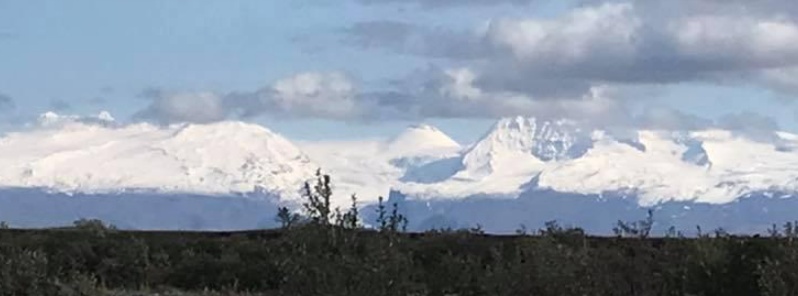
Image credit: Veniaminof, September 21, 2019. Photo courtesy of Bill Stahl, taken from Sandy River.
Over the past several days there have been periods of seismic tremor and occasional earthquakes at Veniaminof volcano, forcing the Alaska Volcano Observatory (AVO) to raise the Aviation Color Code to Yellow and the Volcano Alert Level to Advisory. The volcano has a known history of VEI 1 – 3 eruptions with significant VEI 6 eruption in ~1750 BCE.
This type of seismic activity typically precedes eruptive activity at Veniaminof but does not mean that an eruption will occur, AVO said.
Eruptive activity usually consists of minor ash emissions, lava fountaining and lava flows from the small cone in the summit caldera.
Ash emissions are typically confined to the summit crater, but larger events can result in ashfall in nearby communities and drifting airborne ash.
The last time AVO raised alerts for Veniaminof volcano was on August 2, 2019, after pilot reports of steaming coincided with low-level tremor recorded.
Veniaminof volcano is monitored by local seismic sensors, satellite data, web cameras, and remote infrasound and lightning networks.
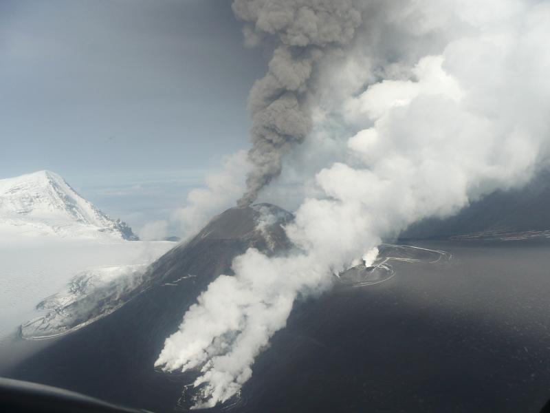
Aerial view of Veniaminof volcano erupting on September 7, 2013. Note the white water vapor clouds indicating hot lava is interacting with snow and ice. A gray-brown ash column rises from the active vent. The summit ice field is darkened with recent ash fall. Photograph by Joyce Alto/AVO.
.JPG)
Aerial view of Veniaminof volcano on September 7, 2013. Photograph by Joyce Alto/AVO.
Geological summary
Veniaminof, on the Alaska Peninsula, is truncated by a steep-walled, 8 x 11 km (5 x 6.8 miles), glacier-filled caldera that formed around 3 700 years ago. The caldera rim is up to 520 m (1 706 feet) high on the north, is deeply notched on the west by Cone Glacier, and is covered by an ice sheet on the south.
Post-caldera vents are located along a NW-SE zone bisecting the caldera that extends 55 km (34 miles) from near the Bering Sea coast, across the caldera, and down the Pacific flank.
Historical eruptions probably all originated from the westernmost and most prominent of two intra-caldera cones, which rises about 300 m (984 feet) above the surrounding icefield. The other cone is larger, and has a summit crater or caldera that may reach 2.5 km (1.5 miles) in diameter, but is more subdued and barely rises above the glacier surface.
I'm a dedicated researcher, journalist, and editor at The Watchers. With over 20 years of experience in the media industry, I specialize in hard science news, focusing on extreme weather, seismic and volcanic activity, space weather, and astronomy, including near-Earth objects and planetary defense strategies. You can reach me at teo /at/ watchers.news.
Commenting rules and guidelines
We value the thoughts and opinions of our readers and welcome healthy discussions on our website. In order to maintain a respectful and positive community, we ask that all commenters follow these rules.