
Widespread Arctic blast across the US breaks century-old records, over 240 million people affected
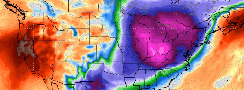
Image credit: Weather Models
Arctic blast continues affecting parts of the US, dumping heavy snow and breaking century-old temperature records. The harsh weather conditions have affected 240 million people – five people have died so far, some schools have postponed classes, establishments have remained closed, and over 1 000 flights have been canceled. Multiple road accidents have also been reported.
The intensity of this Arctic outbreak is comparable to the "Blue Norther" of 1911 in which much of the Plains eastward to the East Coast saw record cold temperatures in the teens and 20s (°F, -6 °C) shortly after record warm temperatures of near 26 °C (80 °F) were observed on the same day, NWS said.
Forecasters said hundreds of records could be either matched or broken this week.
In Madison City, Wisconsin, the daily snowfall record was broken and the record low temperature was tied. On November 11, 2019, 63.5 mm (2.5 inches) of snow fell and the temperature was 9 °C (48.2 °F) – the previous record was 50.8 mm (2 inches) of snowfall in 1981. On November 12, the temperature was 4 °C (39.2 °F) – the previous was 7 °C (44.6 °F), set in 1911 and tied in 1986. Forecasters said Madison could be close to breaking record low for November 13, which was 2 °C (35.6 °F) in 1986.
Started noticing a lot of the now former record lows for Nov 12 were from the year 1911. Yeah, we had weather maps back then. And they're pretty cool. Check it out! pic.twitter.com/VUNZ0uxhh5
— NWS WPC (@NWSWPC) November 13, 2019
Meanwhile, in Kansas, several cities set record low temperatures on November 12 including Wichita, Salina, Russell, Dodge City, Garden City, and Medicine Lodge. The lowest was recorded in Garden City, where it pummeled to -18 °C (-1 °F), breaking 2018's -13.8 °C (7 °F).
Wichita recorded 8 °C (46.4 °F), breaking the previous record of 9 °C (48.2 °F)
Chicago registered -13.8 °C (7 °F) breaking the previous record of -13.3 °C (8 °F) set in 1986.
In Buffalo, around 229 mm (9 inches) of snow broke a 77-year old record.
The National Weather Service said the Tennessee cities of Memphis and Jackson recorded low temperatures for the date Tuesday of -6.1 °C (21 °F) and -7.2 °C (19 °F), respectively. Forecasters said the prior record in Memphis was -5 °C (23 °F) and -6.1 °C (21 °F) in Jackson. NWS also said that Jonesboro, Arkansas, tied a record low of -6.6 °C (20 °F).
#Indy has dropped another degree. The record for the date is now 8°. This is the coldest temperature this early in the season on record. Next closest was 11° on November 3rd, 1951. #Brrr #INwx
— NWS Indianapolis (@NWSIndianapolis) November 12, 2019
Several schools and establishments remained closed on Tuesday due to the unusually cold weather, which also affected road conditions.
In Kansas, a young girl was killed after a truck lost control on an icy road, according to officials.
In Michigan, three people died in a crash believed to be caused by poor road conditions, according to the local sheriff's office.
In the wake of the #ArcticFront: bay-effect streamers, stratocumulus, and jet stream cirrus pic.twitter.com/fV7K8yAUYq
— Stu Ostro (@StuOstro) November 13, 2019
These cities had their most miserable start to #winter, and it's not officially winter yet: https://t.co/vPrTi79HyN pic.twitter.com/4sZHkm4vBO
— The Weather Channel (@weatherchannel) November 12, 2019
In Ohio, sleet-covered roads caused a 50-vehicle pileup that left two people severely injured.
50+ vehicle pileup on I-80 west of Youngstown, OH as intense snow squalls move through region (Image: @WKBN) pic.twitter.com/gonORAy3S9
— Ken Rice (@kenricekdka) November 12, 2019
In Hudson, multiple collisions caused cars to spin off the road. On a separate event in the same area, a bus carrying seven passengers fell on its side when the driver lost control.
Three students from the University of Maine was rescued after being stuck while doing fieldwork in freezing conditions in New England.
In Maine, dozens of events were delayed, including the opening of state offices.
Airlines at O'Hare and Midway airports had to cancel more than 1 000 flights amid snowy conditions.
With the exception of southern Florida, the #ArcticBlast now has the eastern U.S. firmly in its grip, per this chilly moonlit #VIIRS scene. pic.twitter.com/WG3gdJxtFJ
— UW-Madison CIMSS (@UWCIMSS) November 13, 2019
According to NWS's Weather Prediction Center, snows over the Great Lakes will be more widespread on November 13 into Thursday, November 14. However, there will be persistent warm and dry weather over the West, which will continue to raise fire threats for portions of southern California.
On the other hand, the expansive, high-pressure system associated with the current arctic outbreak will start to move east of New England on November 14. Temperature is expected to recover during the period after one more morning of record cold temperatures for some areas from the Mid-Atlantic coast to New England.
Furthermore, an upper-level disturbance quickly moving across the northern Rockies this morning is expected to spread rain and snow eastward from the northern Rockies through the upper Midwest.
"The frontal system associated with this disturbance is on the weak side, and the wet snow should move farther east across the lower Great Lakes and northern New England by Thursday night," the forecast said.
Dramatic 24-hour temperature change across the US. Much of the southern & eastern US saw temps plummet behind a cold frontal passage with some areas over 40° colder since 12PM ET/11AM CT yesterday! Meanwhile the northern Rockies & High Plains are much warmer than this time Monday pic.twitter.com/N2kk3IC0vw
— NWS WPC (@NWSWPC) November 12, 2019
"A secondary cold front will then approach the upper Great Lakes Friday morning, bringing a renewed round of snow into the region. Farther to the south, an upper-level disturbance arriving from northern Mexico will increase the chance of rain along the Gulf Coast as a coastal front forms just offshore on Thursday."
Chances of rain will increase across the Southeast on Thursday night, November 14, as a low-pressure center will form along the coastal front to the south.
There will be warmer and drier conditions over the regions of the Great Basin and Rockies, which will maintain a heightened risk for wildfires.
Commenting rules and guidelines
We value the thoughts and opinions of our readers and welcome healthy discussions on our website. In order to maintain a respectful and positive community, we ask that all commenters follow these rules.