
Hurricane “Barry” makes landfall near Intracostal City, Louisiana
Featured image: Tropical Storm "Barry" forecast track. Credit: NOAA
20:53 UTC, July 13
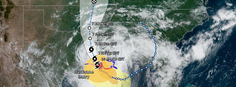
Category 1 Hurricane "Barry" made landfall near Intracostal City, Louisiana and weakened into a tropical storm, NHC said 18:00 UTC.
This made it the 4th hurricane ever to make landfall on the Louisiana coast in July. Previous July landfalls were Hurricane "Bob" in 1979, Danny in 1997 and Cindy in 2005.
128 199 customers in Louisiana are without power as of 20:33 UTC.
Life-threatening flooding is expected as slow-moving Barry continues into central Louisiana and into northern Louisiana on Sunday, July 14.
At 18:00 UTC, the center of Tropical Storm "Barry" was located just north of Intracostal City. It had maximum sustained winds of 115 km/h (70 mph) and minimum central pressure of 996 hPa. It was moving NW at 9 km/h (6 mph).


Hurricane "Barry" at 18:00 UTC on July 13, 2019. Credit: NOAA/GOES-East, TW
15:00 UTC
Barry becomes a hurricane as it is moving onto the Louisiana coast.
Its center was located 65 km (40 miles) S of Lafayette and 80 km (50 miles) W of Morgan City, Louisiana at 15:00 UTC.
Maximum sustained winds were 120 km/h (75 mph) and minimum central pressure 993 hPa.
A Hurricane Warning is in effect for Intracoastal City to Grand Isle.
A Tropical Storm Warning is in effect for Mouth of the Pearl River to Grand Isle; Lake Pontchartrain and Lake Maurepas including metropolitan New Orleans; Intracoastal City to Sabine Pass.
A Storm Surge Warning is in effect for Intracoastal City to Biloxi; Lake Pontchartrain.
A Storm Surge Watch is in effect for Biloxi to the Mississippi/Alabama border.
A Hurricane Watch is in effect for Intracoastal City to Cameron.
On the forecast track, the center of Barry will move through southern Louisiana today, into central Louisiana tonight, and into northern Louisiana on Sunday.

09:32 UTC
Life-threatening Tropical Storm "Barry" is moving closer to the coast of Louisiana and is expected to make landfall along its south-central coast later today (CDT), most likely as a Category 1 hurricane.
At 09:00 UTC on July 13, the center of Tropical Storm "Barry" was located about 90 km (55 miles) SW of Morgan City, Louisiana and 260 km (165 miles) W of the mouth of the Mississippi River.
Its maximum sustained winds were 100 km/h (65 mph) and minimum central pressure 933 hPa. The system was moving WNW at 7 km/h (5 mph).
A motion toward the northwest should begin soon, followed by a turn toward the north tonight or Sunday.
On the forecast track, the center of Barry will make landfall along the south-central Louisiana coast later today. After landfall, Barry is expected to move generally northward through the Mississippi Valley through Sunday night.
Strengthening is forecast before landfall, and Barry is expected to be a hurricane when the center reaches the Louisiana coast later today.
Steady weakening is expected after Barry moves inland.

Tropical Storm #Barry is an unusual storm. In addition to being asymmetrical, #NOAA20’s instruments couldn’t see a convective core last night. This would ordinarily prevent strengthening, but Barry is forecast to attain hurricane status before making landfall in Louisiana. pic.twitter.com/Ja92NJgPNz
— Joint Polar Satellite System (JPSS) (@JPSSProgram) July 12, 2019
Circulation within #TropicalStormBarry is much more apparent in this #GOESEast loop from around 10 a.m. ET. As the storm bears down on the #GulfCoast, heavy rainfall and storm surge remain the biggest threats. Learn more: https://t.co/gyQhFlQuKx pic.twitter.com/vK4vcrkFNL
— NOAA Satellites (@NOAASatellites) July 12, 2019
I really like @Weathernerds's interface for overlaying GLM lightning w/ #GOES16 visible imagery for Barry. The most active lightning is associated with a feeder band SW away from the center.
Pay closer attention to lightning on the SE flank, closer to where the mesovortex is at. pic.twitter.com/vKKgeorZ4h
— Philippe Papin (@pppapin) July 13, 2019
Tropical Storm #Barry now has maximum winds of 65 mph – the strongest July named storm in the Gulf of Mexico since Hurricane Alex in 2010. pic.twitter.com/uROXOklCAw
— Philip Klotzbach (@philklotzbach) July 12, 2019
Key Messages:
1. There is a danger of life-threatening storm surge inundation along the coast of southern and southeastern Louisiana, portions of Lake Pontchartrain, and portions of coastal Mississippi where a Storm Surge Warning is in effect. Water levels have already begun to rise in these areas, with peak inundation expected to occur later today. The highest storm surge inundation is expected between Intracoastal City and Shell Beach.
2. The slow movement of Barry will result in a long duration heavy rainfall and flood threat along the central Gulf Coast, across portions of the Lower Mississippi Valley and north into the Tennessee Valley through the weekend into early next week. Flash flooding and river flooding will become increasingly likely, some of which may be life-threatening, especially across portions of southeast Louisiana into Mississippi.
3. Hurricane conditions are expected along a portion of the coast of Louisiana, where a Hurricane Warning is in effect. Tropical storm conditions are expected elsewhere along much of the Louisiana coast and inland across portions of the lower Mississippi Valley where tropical storm warnings are in effect.


Updates provided by NHC on TC Barry
I'm a dedicated researcher, journalist, and editor at The Watchers. With over 20 years of experience in the media industry, I specialize in hard science news, focusing on extreme weather, seismic and volcanic activity, space weather, and astronomy, including near-Earth objects and planetary defense strategies. You can reach me at teo /at/ watchers.news.
Commenting rules and guidelines
We value the thoughts and opinions of our readers and welcome healthy discussions on our website. In order to maintain a respectful and positive community, we ask that all commenters follow these rules.