
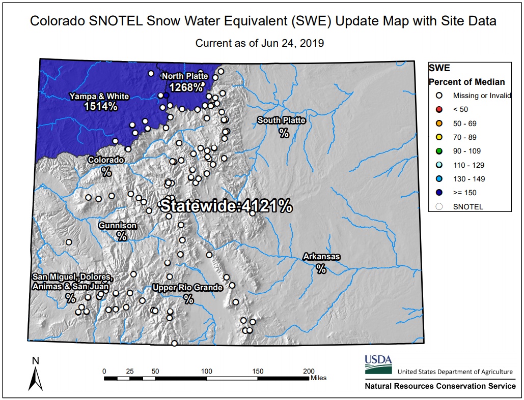
Colorado’s snowpack explodes to 4 121 percent above normal after unexpected heavy summer snow
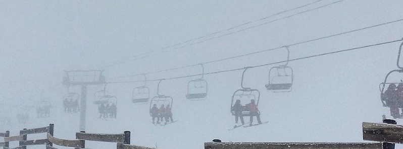
Image credit: Apres LIVE
Snow began falling above 2 100 m (7 000 feet) just west of Denver, Colorado on Friday, June 21, 2019, accumulating to nearly 51 cm (20 inches) over the weekend and boosting the state's snowpack to extraordinary levels for the time of year.
Although the state's snowpack was off the charts – 751% above normal – even before heavy snowfall on the first day of summer, the event was just a continuation of the extra snowy year since January.
When we add all the snow that fell on June 21, the state's snowpack exploded to 4 121 percent above normal.
Steamboat was one of the places that received 51 cm (20 inches) of snow on June 21, making it the first measurable snow this late in season since June 17, 1928.
Steamboat averages 2.5 mm (0.1 inches) of snow in June and normally sees its last day of snow around May 6, making the June 21st snow very rare.
Only in Colorado does it snow the first day of summer pic.twitter.com/cYEAQXKf6c
— Chxv (@CoDude5280) June 21, 2019
Snow in Breckenridge, Colorado! pic.twitter.com/5loJ6mE9Q3
— Jennifer Thompson (@jayhawk2003) June 22, 2019
June 22. Hello summer, nice to see you!
We're open for summer skiing this weekend and next, 8:30 a.m.-2:30 p.m.
We hope to see you up here! #ABasin #TheLegend #LongestSeasonInColorado pic.twitter.com/sh3ybEivir— Arapahoe Basin (@Arapahoe_Basin) June 22, 2019
Who would have thought that we would still be clearing picnic tables of snow in June? Summer Powder day! #whiteroom #ABasin #TheLegend #Skiing #summerskiing pic.twitter.com/HAIdIlauO3
— Arapahoe Basin (@Arapahoe_Basin) June 23, 2019
Into the June #whiteroom today @arapahoe_basin #ski #snowboard nation! #ApresLIVE #SundayFunday #Abasin #TheLegend #longestskiseason #summerskiing #summersnow #mountainlife #colorado #ColoradoLife #COwx #ColoradoMountains #adventures #outdoors #Wanderlust #travel #MountainTravel pic.twitter.com/U3e06B6fFZ
— Après LIVE (@ApresLIVE) June 23, 2019
We sure are lucky to have views like this in #OurCO. pic.twitter.com/gLQ5GvT6NA
— Denver7 News (@DenverChannel) May 24, 2019
High country west of Denver now resembles mid-winter, with enough snow at ski areas to keep them open into July and possibly August.
Just two months ago, more than half of the state was in drought but with all the snow and precipitation since January the drought has now ended.
At the same time, elevated snowpack and runoff are expected to lower Colorado's wildfire risk through the summer.
I'm a dedicated researcher, journalist, and editor at The Watchers. With over 20 years of experience in the media industry, I specialize in hard science news, focusing on extreme weather, seismic and volcanic activity, space weather, and astronomy, including near-Earth objects and planetary defense strategies. You can reach me at teo /at/ watchers.news.
Commenting rules and guidelines
We value the thoughts and opinions of our readers and welcome healthy discussions on our website. In order to maintain a respectful and positive community, we ask that all commenters follow these rules.