
Explosive activity at Manam volcano, Aviation Color Code remains Red, Papua New Guinea
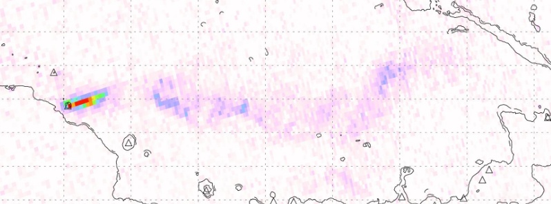
Image credit: Simon Carn, Sentinel-5/Tropomi
Explosive activity continues at Papua New Guinea's Manam volcano, ejecting ash plume to an estimated 3 km (10 000 feet) above sea level since March 1, 2019.
Significant thermal anomalies were detected on March 2 and 3 as well as a plume of SO2 at approximately 3 000 m (10 00 feet) a.s.l., moving towards Rabaul on March 3.
The Aviation Color Code remains Red.
#volcan #volcano #Manam Tout indique qu'un nouveau pic d'activité a commencé le 01/03:signal thermique, détection de cendres, alerte aviation au rouge/All signs are saying that activity peaks again sinces 01/03: red alert for aviation; strong thermal emission, ash. pic.twitter.com/8FtHN3dnJu
— CultureVolcan (@CultureVolcan) March 3, 2019
Scramble the #DCOABOVE drones – SO2 plume from new #eruption at #Manam #volcano (#PapuaNewGuinea) possibly headed towards #Rabaul. Plume reported at ~10,000 feet altitude by @BoM_VAAC_Darwin. Data from #Sentinel5P #Tropomi. @EmmaLiu31 @DrKieranWood pic.twitter.com/GTVvuZtYgY
— Simon Carn (@simoncarn) March 4, 2019
High-impact eruptions took place at the volcano on January 7, 11, 23 and 24, 2019, ejecting ash up to 16.7 km (55 000 feet) above sea level.
The January 23 and 24 eruptions were especially destructive. Locals reported destroyed telecommunication towers, water sources and other infrastructure.
Kessy Sawang, Head of Secretariat at Manam Resettlement Authority, has sent out calls for the immediate evacuation of residents living near the volcano:
Geological summary
The 10-km-wide (6.2 miles) island of Manam, lying 13 km (8 miles) off the northern coast of mainland Papua New Guinea, is one of the country's most active volcanoes. Four large radial valleys extend from the unvegetated summit of the conical 1 807-m-high (5 928 feet) basaltic-andesitic stratovolcano to its lower flanks.
These "avalanche valleys" channel lava flows and pyroclastic avalanches that have sometimes reached the coast. Five small satellitic centers are located near the island's shoreline on the northern, southern, and western sides.
Two summit craters are present; both are active, although most historical eruptions have originated from the southern crater, concentrating eruptive products during much of the past century into the SE valley.
Frequent historical eruptions, typically of mild-to-moderate scale, have been recorded since 1616. Occasional larger eruptions have produced pyroclastic flows and lava flows that reached flat-lying coastal areas and entered the sea, sometimes impacting populated areas. (GVP)
I'm a dedicated researcher, journalist, and editor at The Watchers. With over 20 years of experience in the media industry, I specialize in hard science news, focusing on extreme weather, seismic and volcanic activity, space weather, and astronomy, including near-Earth objects and planetary defense strategies. You can reach me at teo /at/ watchers.news.
Commenting rules and guidelines
We value the thoughts and opinions of our readers and welcome healthy discussions on our website. In order to maintain a respectful and positive community, we ask that all commenters follow these rules.