
Destructive eruption at Manam volcano, residents call urgent evacuation, VA to 16.7 km (55 000 feet) a.s.l., P.N.G.
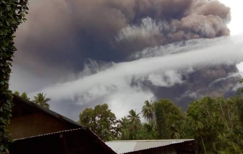
Image credit: Elizah Palme
A new high-impact eruption took place at Manam volcano, Papua New Guinea around 16:20 UTC on January 24, 2019. The volcano is continuously erupting for more than 24 hours and has destroyed telecommunication towers, water sources and other infrastructure. Local residents are sending out calls for immediate evacuation. The Aviation Color Code is Red.
Volcanic ash to 16.7 km (55 000 feet) above sea level, moving west was observed on satellite imagery taken 17:00 UTC. Ongoing volcanic ash to 5.5 km (18 000 feet) is expected to be moving east, the Darwin VAAC reported 17:31 UTC.
The high-level eruption appears to have now ceased and is expected to dissipate within 12 hours.
It comes just one day after another high-impact eruption at Manam ejected ash up to 15.2 km (50 000 feet) a.s.l.
Kessy Sawang, Head of Secretariat at Manam Resettlement Authority, has sent out calls for immediate evacuation of residents living near the volcano:
Manam erupts continuously for 24 hours now as of 1 pm yesterday (unlike only 2 hours in the past). Very high temperatures. Digicel tower destroyed. People may perish next 48 hours if no help goes through.
Chairman of Manam Disaster Working Committee and Ward Member for Baliau just called. Water sources & food gardens completely destroyed.
Urgently need a temporary shelter on mainland. Need MV Godawan or transport for evacuation.
The people of Baliau (2257) and Dugulava were sent back to the volcano by a Government decision. They have no where else to go at the moment.
Chairman MRA Ken Fairweather says we look at Nubia. But immediate is to existing Care Centres where the other IDPs are. Going to Disaster Centre now.
- Kessy Sawang, January 24, 2019
#Volcan #Volcano #Manam Photos de Kessy Sawang via Elizah Palme et derekschen : https://t.co/WcvSf8w4Lphttps://t.co/jRt90Gck6L pic.twitter.com/bcTMInvddq
— Shérine (@SherineFrance) January 24, 2019
- High-impact eruption at Manam volcano, ash to 15.2 km (50 000 feet) a.s.l., Papua New Guinea (January 23, 2019)
- High-level eruption at Manam volcano, ash to 15.2 km (50 000 feet) a.s.l., P.N.G. (January 11, 2019)
- Powerful eruption at Manam volcano, ash to 16.7 km (55 000 feet) a.s.l., P.N.G. (January 1, 2019)
- High-impact eruption at Manam volcano, heavy ashfall blocking sunlight, P.N.G. (December 8, 2018)
- Eruption at Manam volcano ejects ash to 10.4 km (34 000 feet) a.s.l., Aviation Color Code raised to Red, P.N.G. (October 5, 2018)
- High-impact eruption at Manam volcano, 2 000 people flee from lava flows, ash up to 15 km a.s.l., P.N.G. (August 26, 2018)
Geological summary
The 10-km-wide (6.2 miles) island of Manam, lying 13 km (8 miles) off the northern coast of mainland Papua New Guinea, is one of the country's most active volcanoes. Four large radial valleys extend from the unvegetated summit of the conical 1 807-m-high (5 928 feet) basaltic-andesitic stratovolcano to its lower flanks.
These "avalanche valleys" channel lava flows and pyroclastic avalanches that have sometimes reached the coast. Five small satellitic centers are located near the island's shoreline on the northern, southern, and western sides.
Two summit craters are present; both are active, although most historical eruptions have originated from the southern crater, concentrating eruptive products during much of the past century into the SE valley.
Frequent historical eruptions, typically of mild-to-moderate scale, have been recorded since 1616. Occasional larger eruptions have produced pyroclastic flows and lava flows that reached flat-lying coastal areas and entered the sea, sometimes impacting populated areas. (GVP)
I'm a dedicated researcher, journalist, and editor at The Watchers. With over 20 years of experience in the media industry, I specialize in hard science news, focusing on extreme weather, seismic and volcanic activity, space weather, and astronomy, including near-Earth objects and planetary defense strategies. You can reach me at teo /at/ watchers.news.
Commenting rules and guidelines
We value the thoughts and opinions of our readers and welcome healthy discussions on our website. In order to maintain a respectful and positive community, we ask that all commenters follow these rules.