
Major eruption at Ulawun volcano triggers highest Alert Level, ash reaches 18.3 km (60 000 feet) a.s.l., P.N.G.
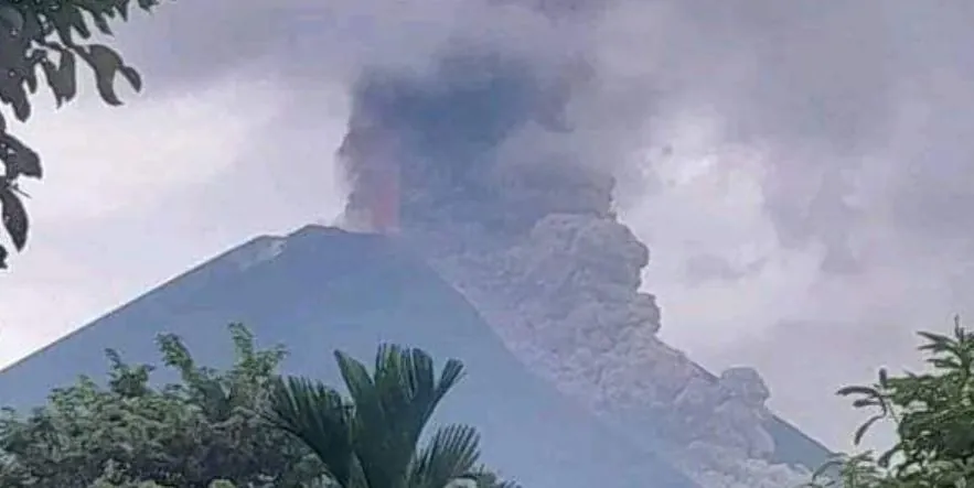
Image credit: Lost Generation via ABC geografija
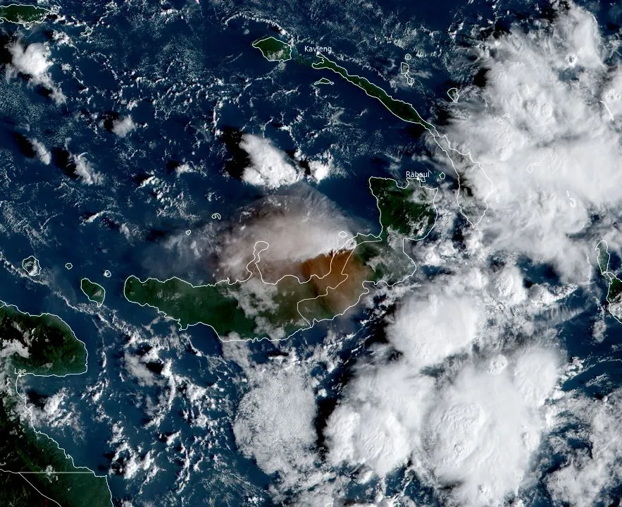
On Monday, November 20, 2023, at approximately 15:30 local time (06:30 UTC), Papua New Guinea’s Ulawun volcano erupted violently, sending volcanic ash as high as 15.2 km (50 000 feet) above sea level. The Aviation Color Code was raised to Red and the Alert Level to 4 (highest). Despite widespread rumors, no tsunami warnings have been issued for the surrounding regions, including Japan and Australia.
The Geohazards Management Division of Papua New Guinea promptly responded by raising Ulawun’s volcanic Alert Level to the maximum stage of four. The Division also highlighted that the eruption is expected to continue for an indefinite period.
The Aviation Color Code was raised to Red, with ash cloud height reported as high as 15 km (50 000 feet) at 06:30 UTC, moving west of the volcano.
Prije nekoliko sati počela je erupcija vulkana Ulawun (Papua i Nova Gvineja). Stup pepela iznad vulkana trenutno doseže visinu od 15 km. Koliki utjecaj će ova velika erupcija imati na puno šire područje ovisi o tijeku erupcije i vjetrovima.
— ABC geografija (@abc_geografija) November 20, 2023
Foto: Lost Generation#geografija pic.twitter.com/AwElZrE4BS
By 07:20 UTC, the plume was extending approximately 55 km (34 miles). The height of the plume to 15 km a.s.l. was based on IR temperatures of approximately -60 °C (-76 °F).
At 14:20 UTC, Darwin VAAC said the volcanic plume continues moving W at a height of 15 km a.s.l. At the time, it was extending 518 km (322 miles) W of the volcano. The Aviation Color code remains Red.
Despite initial concerns and media speculation, there is no tsunami warning in effect following the eruption. The Japan Meteorological Agency (JMA) assessed the potential for a tsunami affecting Japanese coasts but has not issued any advisories or warnings. They noted no significant sea level changes at observation sites in and around Japan.
Similarly, Geoscience Australia and the Pacific Tsunami Warning Center confirmed that there is no tsunami threat to Australian waters. However, JMA has advised coastal residents to remain cautious due to the unpredictability of delayed tsunami waves.
En erupción el volcán #Ulawun, ubicado en la isla Nueva Bretaña de Papúa Nueva Guinea🇵🇬
— SkyAlert (@SkyAlertMx) November 20, 2023
La columna eruptiva es superior a los 10 km sobre el cráter. Se reportan oleadas piroclásticas de alcance intermedio.
No hay poblaciones en la zona de mayor riesgo. pic.twitter.com/r37QnLwtQy
Just to highlight what a busy, ice-rich convective environment Papua New Guinea is, here is the ‘ash probability’ loop for #Ulawun #eruption using the excellent @UWCIMSS site. Ground photos show an ash-rich eruption. Surrounding convection is 15+ km pic.twitter.com/J8jsJdPutk
— Andrew Tupper (@andrewcraigtupp) November 20, 2023
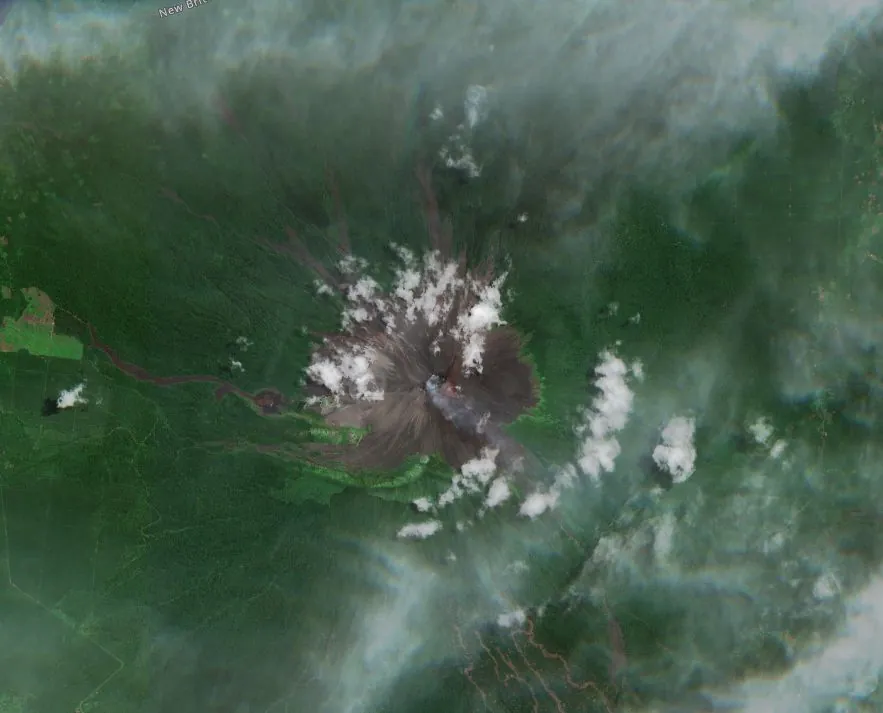
Ulawun, also known as “The Father,” is the highest volcano of the Bismarck Arc and one of the most frequently active volcanoes in Papua New Guinea. Situated on the Pacific “Ring of Fire,” it has a history of both explosive and effusive eruptions.
The volcano’s structure includes a symmetrical basaltic-to-andesitic stratovolcano, with satellitic cones and a prominent escarpment. Historical records indicate eruptions dating back to the early 18th century, with the most recent major eruption occurring in 2019.
Updates
November 21, 07:31 UTC
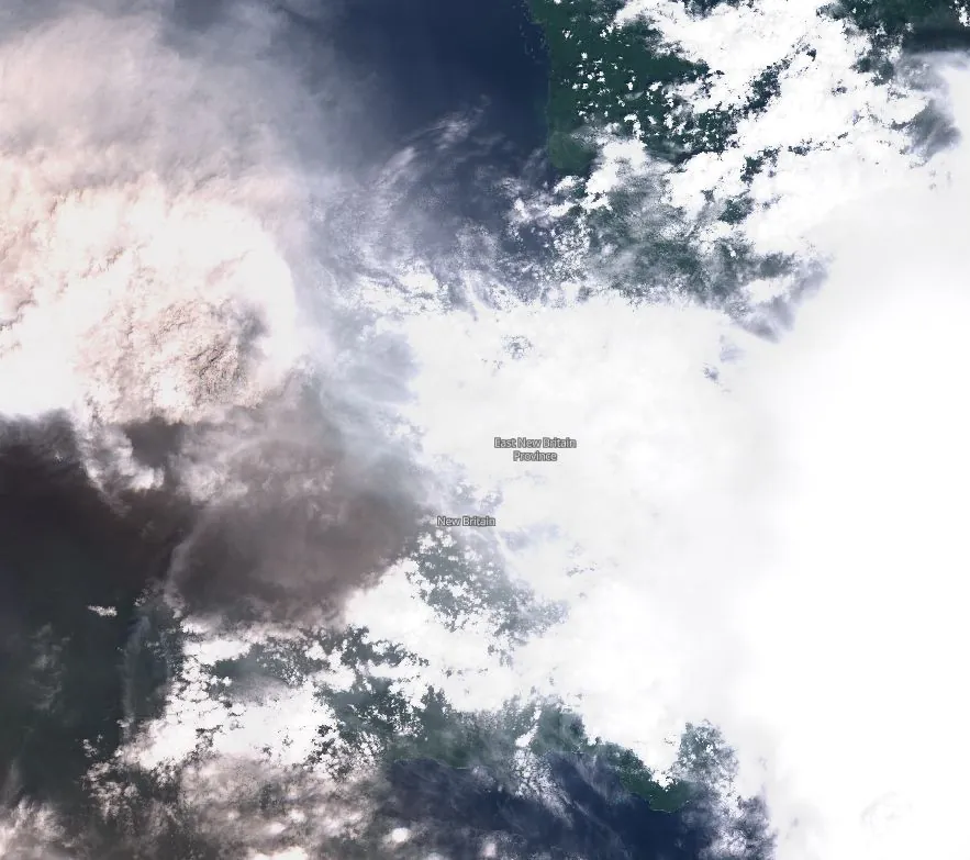
Stratospheric volcanic ash was observed reaching 18.2 km (60 000 feet) a.s.l. at 18:50 UTC on November 20, and extending approximately 74 km (46 miles) SE of the summit, Darwin VAAC reported at 19:15 UTC. In addition, a continuous volcanic ash plume to 15.2 km (50 000 feet) a.s.l. was extending approximately 425 km (264 miles) west of the summit.
Mt #Ulawun emits volcanic ash across #WestNewBritain, #PNG as at 20Nov23. pic.twitter.com/bYzudpBajN
— Michael Dotaona (@borderlogix_md) November 21, 2023
#volcan #volcano #Ulawun L'activité éruptive reste fortement explosive ce matin (altitude du panache évaluée à 18 km)/Strong explosive activity is ongoing this morning (altitude reached by the plume estimation : 18 km) via Himawari 8 & VAAC Darwin pic.twitter.com/gUV840fuZH
— CultureVolcan (@CultureVolcan) November 21, 2023
🇵🇬 🌋 ¡Desde el satélite!
— Red Geocientífica de Chile (@RedGeoChile) November 21, 2023
El paroxismo del volcán #Ulawun en la región de Nueva Bretaña en Papúa Nueva Guinea alcanzó a verse fácilmente por el satélite geoestacionarios Himawari-9 evidenciando la dispersión del material expulsado. pic.twitter.com/HtkFMMNNaZ
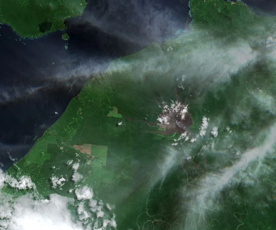
Dawn on the island revealed intense ashfall was experienced in different locations, including Soi, Kabay and Navo on the northern coast of New Britain.
🚫 ✈️ Air Niugini ha suspendido todos los vuelos a #Hoskins debido a la caída de ceniza volcánica en la pista y las calles de rodaje, y en las proximidades del aeropuerto. Código Rojo 🔴 para el transporte aéreo se mantiene por ceniza en suspensión. pic.twitter.com/iODmEMPBel
— Red Geocientífica de Chile (@RedGeoChile) November 21, 2023
In a new advisory, issued at 07:00 UTC on November 21, Darwin VAAC noted that continuous volcanic ash to 12.2 km (40 000 feet) a.s.l. was observed on recent satellite imagery. Volcanic ash observed to 18.2 km (60 000 feet) and extending east of the summit is expected to dissipate within the next 12 hours.
The Aviation Color Code remains Red.
References:
1 Darwin VAAC – VA Advisories – November 20, 2023
2 Papua New Guinea volcano erupts and Japan says it’s assessing a possible tsunami risk to its islands – AP – November 20, 2023
3 Ulawun – Geological Summary – GVP
I'm a dedicated researcher, journalist, and editor at The Watchers. With over 20 years of experience in the media industry, I specialize in hard science news, focusing on extreme weather, seismic and volcanic activity, space weather, and astronomy, including near-Earth objects and planetary defense strategies. You can reach me at teo /at/ watchers.news.
Commenting rules and guidelines
We value the thoughts and opinions of our readers and welcome healthy discussions on our website. In order to maintain a respectful and positive community, we ask that all commenters follow these rules.