
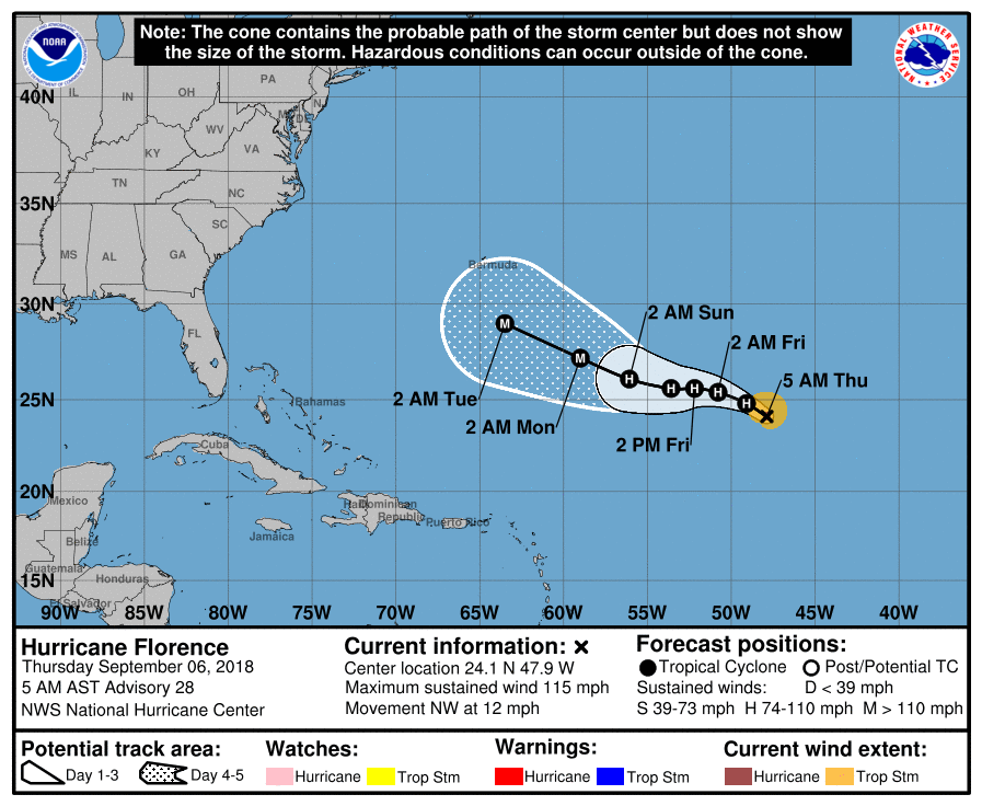
Hurricane “Florence” becomes the first major hurricane of 2018 Atlantic season, heading toward Bermuda and U.S. East Coast

Featured image: Hurricane "Florence" at 09:30 UTC on September 6, 2018. Credit: NOAA/GOES-East
Hurricane "Florence" underwent a rapid intensification phase on September 5, 2018 and became the first major hurricane of the 2018 Atlantic hurricane season. The cyclone has slightly weakened today but is forecast to remain a strong hurricane for the next several days and possibly restrengthen. It's still to early to be sure where the cyclone will end, but current track takes its center near Bermuda and toward U.S. East Coast. Regardless of Florence's eventual track, large swells emanating from the hurricane will reach Bermuda beginning on Friday, September 7 and portions of the U.S. East Coast this weekend, resulting in life-threatening surf and rip currents.
The NHC first mentioned the possibility of tropical cyclone formation from a tropical wave expected to exit western Africa on August 28. On August 30, this tropical wave moved off the coast of Senegal with disorganized thunderstorms and a well-defined low-pressure area. The system organized into Tropical Depression Six at 21:00 UTC on August 31 and strengthened into Tropical Storm "Florence" early September 1.
Gradual intensification occurred as Florence continued west-northwestward across the central Atlantic and at 15:00 UTC on September 4 it intensified into the third hurricane of the season.
On September 5, Florence unexpectedly underwent rapid intensification into a Category 3 major hurricane and by 21:00 UTC intensified into a Category 4 hurricane.
Its center was located at 22.4°N 46.2°W at the time, farther northeast than any previous Category 4 hurricane in the Atlantic.
Early on September 6, Florence weakened back into a Category 3 hurricane, due to wind shear but is expected to remain a strong hurricane for the next several days and possibly restrengthen.

Hurricane "Florence" at 09:30 UTC on September 6, 2018. Credit: NOAA/GOES-East
At 09:00 UTC on September 6, the center of Hurricane "Florence" was located 1 885 km (1 170 miles) ESE of Bermuda. Its maximum sustained winds were 185 km/h (115 mph) and minimum central pressure 964 hPa. The cyclone was moving NE at 19 km/h (12 mph). A turn toward the WNW with a decrease in forward speed is expected later today, followed by a turn toward the west by the weekend.
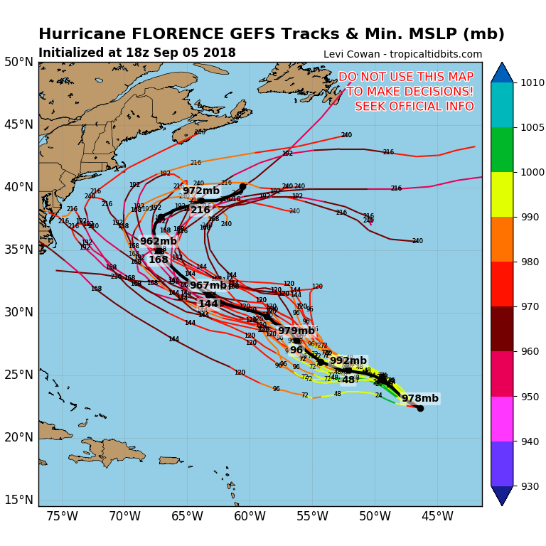
Given the wind shear and current appearance of Florence, additional weakening in the short-term seems likely, and all of the intensity guidance agrees, NWS forecaster Zelinsky notes. From 24 – 72 h, the spread increases with the statistical models generally showing continued gradual weakening for another day or two, while the dynamical models show little change or slight restrengthening. All of the guidance calls for Florence to restrengthen by September 11.
There is still considerable model ensemble spread for Florence's track beyond September 11 and given the large uncertainty at these time ranges, it is far too soon to speculate what, if any, impacts Florence may have on the U.S. East Coast next week.
Regardless of Florence's eventual track, large swells emanating from the hurricane will reach Bermuda beginning on Friday, September 7 and portions of the U.S. East Coast this weekend, resulting in life-threatening surf and rip currents.
I'm a dedicated researcher, journalist, and editor at The Watchers. With over 20 years of experience in the media industry, I specialize in hard science news, focusing on extreme weather, seismic and volcanic activity, space weather, and astronomy, including near-Earth objects and planetary defense strategies. You can reach me at teo /at/ watchers.news.
Commenting rules and guidelines
We value the thoughts and opinions of our readers and welcome healthy discussions on our website. In order to maintain a respectful and positive community, we ask that all commenters follow these rules.