
Mini ozone hole appears over western Canada
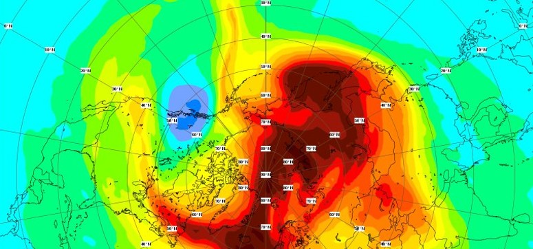
Featured image: Mini ozone hole appears over western Canada. Credit: ECMWF/Copernicus
On February 7, 2018, the Copernicus Atmosphere Monitoring Service or CAMS, has successfully predicted the appearance of an ozone mini-hole over western Canada on February 12 or 13. Sudden stratospheric warmings like the one currently in progress have been shown to precede the formation of these localized ozone depletion events.
Satellite observations acquired on February 12 and 13 data assimilation confirmed predictions made by ECMWF's CAMS, proving its model really works and can accurately predict these kinds of events.
Below is a comparison of the model prediction based 00:00 UTC, February 9 and valid on 03:00 UTC, February 13, of the very short range (3 hour) forecast from the model analysis relying on several satellite observations from February 12 and valid for February 13, 03:00 UTC and of measurements from the OMI satellite instrument on February 13.


Ozone mini-holes at high northern latitudes are relatively rare as the topography of the continents surrounding the Arctic generally disrupts the polar vortex and prevents the formation of polar stratospheric clouds involved in the chemical reactions that produce chlorine atoms, which are responsible for fast ozone depletion in the mini-holes.
"Our forecast shows that this mini ozone hole will probably persist for a few more days and maybe shift a little towards the East or into the U.S. but it will eventually dissipate," says Mark Parrington, senior scientist for CAMS.
Sudden stratospheric warmings have been shown to precede the formation of these localized ozone depletion events.

Teo Blašković founded The Watchers in 2011 and edited it until 2026, covering seismic and volcanic activity, extreme weather, space weather and near-Earth objects. Articles on this page are his archive.
Earlier reporting
Nothing on Watchers was published in the last 24 hours. These are older articles.
- On October 22, 2017, a single flash of lightning stretched 515 miles from eastern Texas to near Kansas City, a distance that takes eight hours to drive, and nobody realized how far it had gone until scientists went back through the satellite data years later Epicenter
- CPC posts a slight risk of heavy rain from the Gulf Coast to the Northeast urban corridor November 25-29, and a moderate risk of West Coast wind and Sierra snow on November 25
- Florida's east coast faces a moderate flash flood risk Wednesday through Friday, with 4 to 8 inches of rain forecast and the St. Johns River near Cocoa already in major flood at 17.13 feet
- Cyclone Akvan to make landfall between Nellore and Visakhapatnam around noon on November 20, IMD forecasts 120-130 km/h winds gusting to 145
