
Warnings issued as Sudden Stratospheric Warming threatens Europe with big freeze
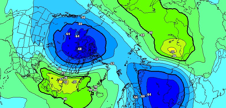
Image credit: Meteociel.fr
Weather models are suggesting a very high probability of a rare North Pole weather phenomenon called Sudden Stratospheric Warming (SSW) taking place later this month and bringing prolonged bitterly-cold temperatures to the United Kingdom and parts of Europe. Such weather event hasn't occurred since 2010 when it brought coldest March for 51 years to Scotland.
"There is a clear indication of an imminent split in the polar vortex, currently located over central-western Greenland. The main center will drift to the Canadian Plains, while a new area will form over northern Russia," TWC forecaster Dr. Dave Reynolds said. "This will drift towards the Caspian Sea, then westwards across the Mediterranean, Iberia and out to the near Atlantic during the next two weeks, weakening as it does so."
The polar vortex is expected to split during Thursday, February 8 and Friday, February 9, and become well developed by Sunday, February 11.
"The process of vortex splitting is accompanied by Sudden Stratospheric Warming, whereby temperatures in the stratosphere rise. This warming can then extend downwards through the depth of the atmosphere and result in an increased risk of blocking, which in winter-time raises the chance of widespread cold conditions developing," said Reynolds.
This process won't take place overnight as it usually takes 10 to 25 days to form and there is still uncertainty of how things will develop. However, computer models indicate a cold, blocked pattern over Scandinavia for the last week of February and first week of March, reinforced by a possible polar vortex split and accompanying stratospheric warming.
The warning is contained in the UK government official February to April forecast being briefed to the Cabinet Office, transport bosses, councils and emergency services.
The UK Met Office Meteorologist Aidan McGivern takes a look at the trend during the next 10 days and explains the phenomenon:
A Sudden Stratospheric Warming is an event in which the polar vortex of westerly winds in the winter hemisphere slows down or even reverses direction over the course of a few days. The change is accompanied by a rise of stratospheric temperature by several tens of kelvins.
Although sudden stratospheric warmings are mainly forced by planetary-scale waves which propagate up from the lower atmosphere, there is also a subsequent return effect of sudden stratospheric warmings on the surface weather.
Following SSW, the high altitude winds reverse to flow eastward instead of their usual westward. The eastward winds progress down through the atmosphere and weaken the jet stream, often giving easterly winds near the surface and resulting in dramatic reductions in temperature in Europe.
I'm a dedicated researcher, journalist, and editor at The Watchers. With over 20 years of experience in the media industry, I specialize in hard science news, focusing on extreme weather, seismic and volcanic activity, space weather, and astronomy, including near-Earth objects and planetary defense strategies. You can reach me at teo /at/ watchers.news.
SO, WE’RE ALL DOOMED?