
Mount Agung erupts ash 4.5 km a.s.l., Alert Level remains at 3
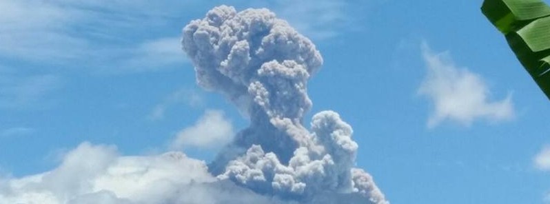
Featured image: Mount Agung erupting on February 13, 2018. Credit: BNPB
Mount Agung erupted at 03:49 UTC on February 13, 2018, ejecting a column of ash up to 4.5 km (15 000 feet) above sea level, that's 1.5 km (5 000 feet) above the crater. The eruption comes two days after authorities lowered Alert Level from 4 to 3, the second highest.
At this point, ash is not affecting flights in Bali and the Aviation Color Code remains at Orange.
Seismic activity under the volcano is dominated by low-frequency earthquakes related to steam and gas emission on the crater. Some high-frequency volcanic earthquakes are still recorded, indicating that magma movement inside the volcano remains active, however with low intensity.
The eruption comes two days after authorities lowered Alert Level from 4 to 3, the second highest, as several indicators showed a drastic decrease in activity in the past month.
Gempa letusan Gunung Agung terjadi pada 13/2/2018 pukul 11:49 WITA dengan tinggi kolom asap dan abu 1500 meter di atas puncak. Status Siaga (level 3). Zona berbahaya di dalam radius 4 km dari puncak kawah. Sebanyak 15.445 orang masih mengungsi tersebar di 146 titik pengungsian. pic.twitter.com/g61LGDOV0f
— Sutopo Purwo Nugroho (@Sutopo_PN) February 13, 2018
Gempa letusan Gunung Agung terjadi pada 13/2/2018 pukul 11:49 WITA dengan tinggi kolom asap dan abu 1500 meter di atas puncak. Status Siaga (level 3). Zona berbahaya di dalam radius 4 km dari puncak kawah. Sebanyak 15.445 orang masih mengungsi tersebar di 146 titik pengungsian. pic.twitter.com/7Ga1oRofzu
— Sutopo Purwo Nugroho (@Sutopo_PN) February 13, 2018
More than 140 000 people living around Agung were evacuated after its alert level was raised to 4 on September 22, 2017. With the alert level now at 3, all villagers with homes outside of the 4 km (2.5 miles) radius can return.
"People’s activities, as well as tourism in Bali, has been declared safe and there will be no more disruption related to the volcano at this time," Ignasius Jonan, the minister of energy and natural resources, said.
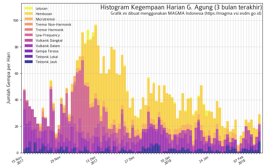
Earthquakes under Mount Agung, Bali, Indonesia from November 15 to February 7, 2018. Credit: MAGMA Indonesia
Geological summary
Symmetrical Agung stratovolcano, Bali's highest and most sacred mountain, towers over the eastern end of the island. The volcano, whose name means "Paramount," rises above the SE caldera rim of neighboring Batur volcano, and the northern and southern flanks of Agung extend to the coast.
The 3142-m-high (10 308 feet) summit contains a steep-walled, 500-m-wide (1 640 feet), 200-m-deep (656 feet) crater. The flank cone Pawon is located low on the SE side.
Only a few eruptions dating back to the early 19th century have been recorded in historical time. The 1963-64 eruption, one of the world's largest of the 20th century, produced voluminous ashfall along with devastating pyroclastic flows and lahars that caused extensive damage and many fatalities. (GVP)
I'm a dedicated researcher, journalist, and editor at The Watchers. With over 20 years of experience in the media industry, I specialize in hard science news, focusing on extreme weather, seismic and volcanic activity, space weather, and astronomy, including near-Earth objects and planetary defense strategies. You can reach me at teo /at/ watchers.news.
Commenting rules and guidelines
We value the thoughts and opinions of our readers and welcome healthy discussions on our website. In order to maintain a respectful and positive community, we ask that all commenters follow these rules.