
At least 4 killed as Tropical Storm “Sanba” makes landfall, Philippines
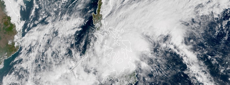
Featured image: Tropical Storm "Sanba" at 02:10 UTC on February 13, 2018. Credit: JMA/Himawari-8
Tropical Storm "Sanba," known as Basyang in the Philippines, slammed into Mindanao on Tuesday, February 13, 2018 bringing heavy rain and producing wind gusts of 75 km/h (46 mph).
The cyclone made landfall in Cortes, Surigao del Sur province around 03:00 UTC today. It dropped heavy rain that triggered landslides in mountain villages near Carrascal, some 760 km (470 miles) south of Manila, killing at least four people.
The area is currently inaccessible and authorities don't know the extent of the damage yet.
Scattered to widespread moderate to heavy rains will prevail in the next 24 hours over Palawan and Visayas, PAGASA said.
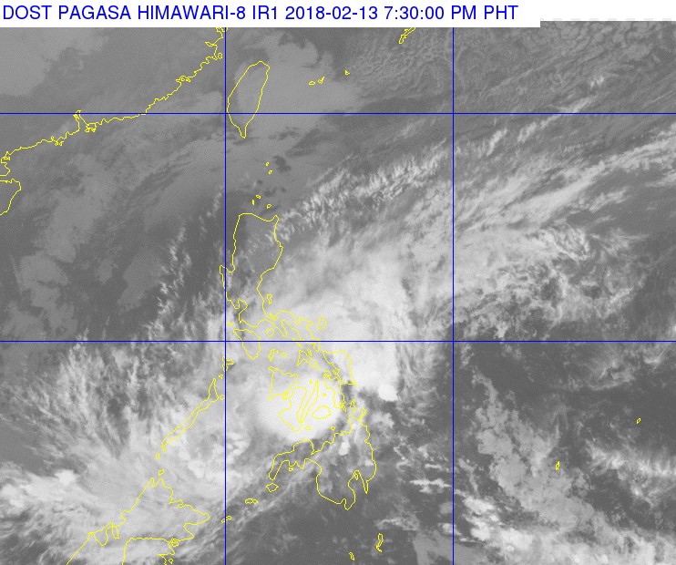
Tropical Depression "Sanba" at 11:30 UTC on February 13, 2018. Credit: JMA/Himawari-8, PAGASA
Meanwhile, scattered light to moderate with at times heavy rains is expected over Bicol Region, Zamboanga Peninsula, Northern Mindanao, Caraga, and the provinces of Basilan, Sulu and Tawi-Tawi.
Residents of these areas must continue monitoring for updates, take appropriate measures against possible flooding and landslides, and coordinate with their respective local disaster risk reduction and management offices, the agency said.
Situation sa Villa Corito Highway, Surigao City right now
Feb 13, 2018 (9:40AM) #baha #basyangph #sanba #bagyo pic.twitter.com/iAoKPcMOXc— tennisheads (@tennisheads) February 13, 2018
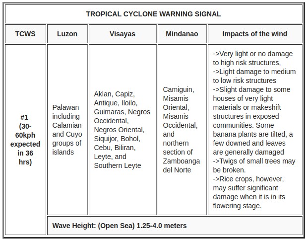
Sea travel remains risky over the seaboards of areas under Tropical Cyclone Warning Signals (TCWS), as well as the seaboards of Northern Luzon and of Visayas, the eastern seaboards of Central Luzon and of Mindanao, and the eastern and southern seaboards of Southern Luzon due to the Sanba, now a tropical depression, and the surge of the Northeast Monsoon.
At 08:00 UTC today, the center of Tropical Depression "Sanba" was located 25 km (15 miles) SE of Tagbilaran City, Bohol. Its maximum sustained winds near the center were 45 km/h (28 mph) with gusts to 65 km/h (40 mph).
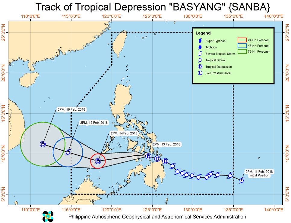
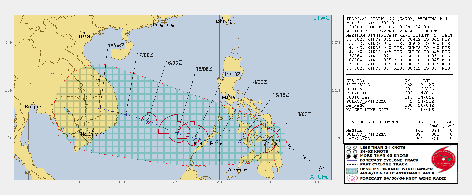
Although sea surface temperatures are still favorable, Sanba is now interacting with land which is limiting its development.
Over the next 24 hours, it will slightly weaken and track over Palawan before it heads out into warm waters of the South China Sea.
This will allow slight intensification but Sanba will reach cooler waters after 09:00 UTC on February 15 which will make it decrease in intensity again. It will continue to weaken on February 16 and have the intensity of about 45 km/h (28 mph) before making landfall in Vietnam where it will dissipate by 09:00 UTC on February 18.
I'm a dedicated researcher, journalist, and editor at The Watchers. With over 20 years of experience in the media industry, I specialize in hard science news, focusing on extreme weather, seismic and volcanic activity, space weather, and astronomy, including near-Earth objects and planetary defense strategies. You can reach me at teo /at/ watchers.news.
Commenting rules and guidelines
We value the thoughts and opinions of our readers and welcome healthy discussions on our website. In order to maintain a respectful and positive community, we ask that all commenters follow these rules.