
Dry thunderstorms add ignition risk in New Mexico as Critical fire weather develops across the western U.S.
A multi-day fire-weather setup is developing across the Southwest, Great Basin and central Rockies, where the Storm Prediction Center and local National Weather Service offices forecast strong southwest winds, very low humidity, dry fuels and isolated dry thunderstorms through at least Tuesday, June 9.
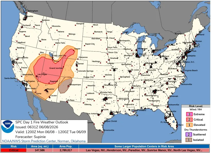
SPC Day 1 Fire Weather Outlook valid 24 hours to 12:00 UTC on June 9, 2026. Credit: NWS/SPC
The Storm Prediction Center (SPC) placed 382 246 km² (147 586 mi²) in the Day 1 Critical fire weather area across portions of the Southwest, Great Basin, and central Rockies, with around 2.8 million people inside the risk area. Larger population centers include Las Vegas, Henderson, Paradise, Sunrise Manor, and North Las Vegas, Nevada.
Strong winds, relative humidity near 5–15%, dry fuels, and poor overnight humidity recovery are expected to overlap across the region as a persistent longwave trough remains in place over the northwestern contiguous United States.
Embedded perturbations moving through a belt of strong flow and associated surface low pressure will support breezy conditions across the Southwest, Great Basin, and central Rockies. Strong vertical mixing and a tightening pressure gradient are forecast to produce afternoon winds of 30–50 km/h (20–30 mph) with relative humidity near 5–15%.
An Isolated Dry Thunder area was maintained across parts of northwestern New Mexico for Monday afternoon. SPC cited strong diurnal heating, a compact jet maximum aloft, mid-level moisture, a very dry boundary layer, and fast storm motions, with dry fuels already present across the area.
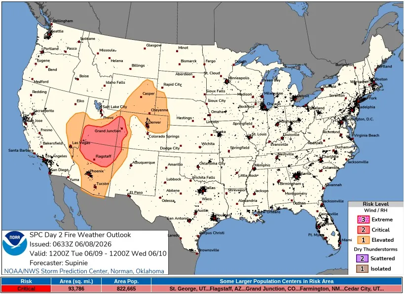
The Critical risk continues into Tuesday, June 9, when SPC placed 242 905 km² (93 786 mi²) across portions of the Southwest and Great Basin in the Day 2 Critical fire weather area, valid from 12:00 UTC on June 9 to 12:00 UTC on June 10. The Day 2 area includes around 820 000 people, with St. George, Flagstaff, Grand Junction, Farmington, and Cedar City listed among the larger population centers.
For Tuesday, SPC forecasts the same core fire-weather parameters across much of the region: southwest winds of 32–48 km/h (20–30 mph) and afternoon relative humidity of 5–15%. Poor overnight humidity recovery is expected to keep fuels critically dry across the Southwest and Great Basin.
Parts of the central High Plains and foothills have been placed in an Elevated area on Tuesday, where winds of 32–48 km/h (20–30 mph), locally higher gusts, and relative humidity of 10–15% are forecast west of a dryline. The agency kept that area below Critical because recent precipitation, and additional precipitation possible Monday, left greater uncertainty over fuel status.
Local National Weather Service (NWS) offices issued or maintained Red Flag Warnings and Fire Weather Watches across several parts of the outlook area.
NWS Las Vegas said widespread gusty southwesterly winds, low humidity, and dry fuels would produce elevated to critical fire-weather conditions across much of its region, with warnings in effect for northwestern Arizona, most of southern Nevada, and the Nevada side of the Colorado River.
Farther east, NWS Grand Junction reported widespread Red Flag Warnings and Fire Weather Watches through Wednesday across western Colorado and eastern Utah. The office forecast common afternoon gusts of 40–55 km/h (25–35 mph), with Tuesday the windiest day and gusts exceeding 70 km/h (45 mph) in some locations.
Very dry surface layers are expected to keep minimum daytime humidity in the single digits and low teens across the Grand Junction forecast area. The office also forecast localized gusts up to 80 km/h (50 mph), with isolated dry thunderstorms at times over the next several days, increasing the potential for new fire starts.
In New Mexico, NWS Albuquerque placed Red Flag Warning conditions over parts of the west, including the Gallup area, where breezy southwest winds and single-digit minimum humidity are expected. The office said high-based showers and dry thunderstorms would develop from the Continental Divide to the central mountain chain, with erratic downburst gusts above 80 km/h (50 mph) from stronger cells, and concern that dry strikes on Monday would become more problematic under stronger southwest winds on Tuesday.
Southern Nevada is forecast to see southwest winds of 32–40 km/h (20–25 mph), gusts up to 64 km/h (40 mph), and humidity of 5–15%, with the NWS warning that fires starting under these conditions would be capable of rapid spread, and that outdoor burning is not recommended.
Several zones in Utah and Colorado are expecting southwest winds of 32–48 km/h (20–30 mph), gusts up to 64–89 km/h (40–55 mph) and minimum relative humidity values as low as 6–13%. NWS warned that new fire starts or existing fires could spread rapidly under critical fire-weather conditions.
The National Interagency Fire Center (NIFC) June 1 outlook placed above-normal significant fire potential across much of the West in June, including most of the Greater Four Corners, central Great Basin, Inland Northwest, and northern California. The outlook included above-normal June potential in lower elevations of central and southern California, the Powder River Basin in northeast Wyoming, and areas near the Canadian border from far eastern Montana into northern Lower Michigan.
NIFC said drought persisted, intensified, or developed across many areas of the western United States, the northern High Plains, and parts of the Midwest during May, while nearly 61% of the country remained in drought as of May 26.
The agency said precipitation was largely below normal across most of the West, northern Plains and Midwest, with pockets of above-normal precipitation in parts of central and northern California, western Nevada, south-central Oregon, central and eastern Colorado, and northwest to north-central Montana.
National fire activity was already running above the 10-year average before the current outlook period. The NIFC / National Interagency Coordination Center (NICC) Incident Management Situation Report listed 31 909 fires and 1 016 953 ha (2 512 945 acres) burned nationally year-to-date, compared with a 10-year average of 23 015 fires and 539 964 ha (1 334 280 acres).
NICC Predictive Services forecast widespread elevated to critical conditions across much of the eastern Great Basin, Southwest west of the Divide, and central Rockies, with southwest winds of 25–50 km/h (15–30 mph), gusts of 50–70 km/h (30–45 mph), relative humidity of 5–15%, and isolated dry thunderstorms from the northern Front Range of Colorado into eastern Wyoming and across much of northwestern New Mexico.
References:
1 Day 1 Fire Weather Outlook – NWS/SPC – June 8, 2026
2 Day 2 Fire Weather Outlook – NWS/SPC – June 8, 2026
I'm a dedicated researcher, journalist, and editor at The Watchers. With over 20 years of experience in the media industry, I specialize in hard science news, focusing on extreme weather, seismic and volcanic activity, space weather, and astronomy, including near-Earth objects and planetary defense strategies. You can reach me at teo /at/ watchers.news.
Commenting rules and guidelines
We value the thoughts and opinions of our readers and welcome healthy discussions on our website. In order to maintain a respectful and positive community, we ask that all commenters follow these rules.