
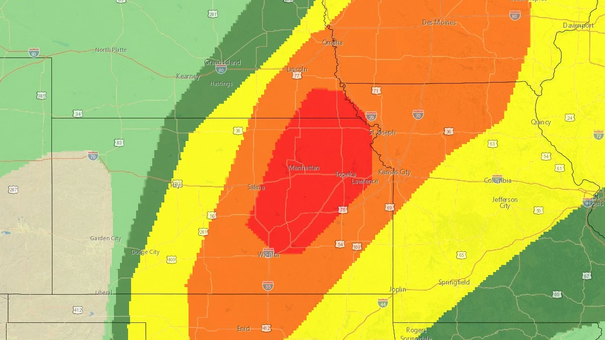
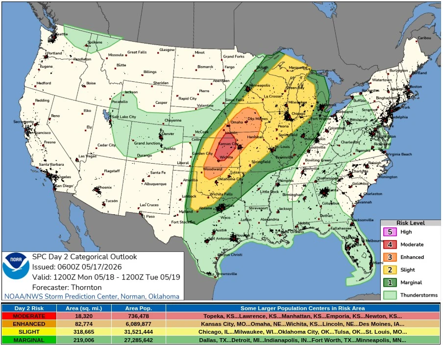
SPC issues Moderate Risk for strong to intense tornadoes and giant hail across Kansas and Nebraska
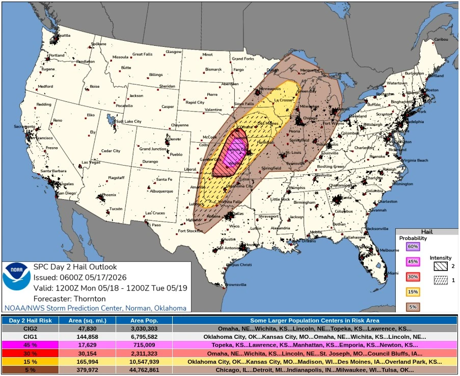
The Storm Prediction Center (SPC) placed portions of central and northeastern Kansas into far southeastern Nebraska under a Moderate Risk for severe thunderstorms on Monday, May 18, 2026. Supercells are forecast to produce all severe hazards, including 5–10+ cm (2–4+ inches) hail and strong to intense tornadoes, mainly from central Kansas into southeastern Nebraska.
Convective Outlook valid 24 hours to 14:00 EDT on May 19, 2026. Credit: NWS/SPC
Numerous severe thunderstorms are forecast along a cold front and dryline extending from the Great Lakes into the central and southern Plains on Monday, May 18. The primary severe-weather corridor is forecast near the surface low, dryline, and cold-front triple point across central Kansas into southeastern Nebraska, with additional severe potential into southwestern Iowa and northwestern Missouri.
Morning cloud cover over central Kansas is forecast to erode by Monday afternoon, allowing temperatures ahead of the dryline to approach about 29–32°C (84–90°F), with dew points of about 20–26°C (68–79°F). The environment is forecast to support moderate to strong MLCAPE of about 3 500–4 500 J/kg from central Kansas into southeastern Nebraska.
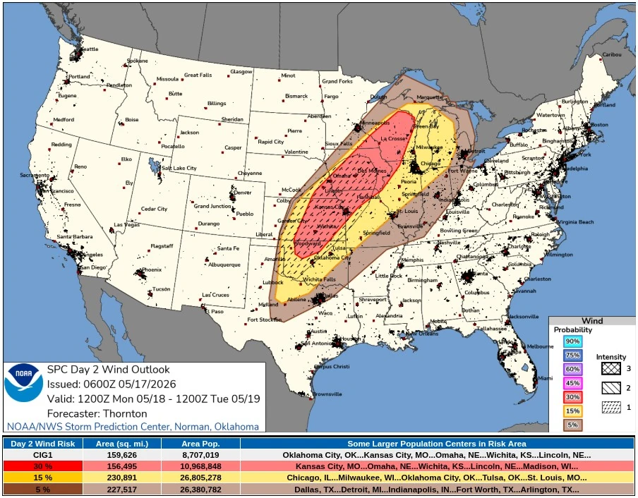
Convective inhibition is forecast to erode from 13:00–15:00 CDT, with thunderstorm initiation along the dryline and cold front around 15:00–16:00 CDT. Forecast soundings support organized supercells, with deep-layer shear of about 75–95 km/h (45–60 mph). Initial supercells are forecast to produce large to giant hail of 5–10+ cm (2–4+ inches).
The southerly low-level jet is forecast to strengthen through the afternoon and evening, peaking near 75–95 km/h (45–60 mph) from 19:00–22:00 CDT on May 18 across northern Oklahoma into central Kansas.
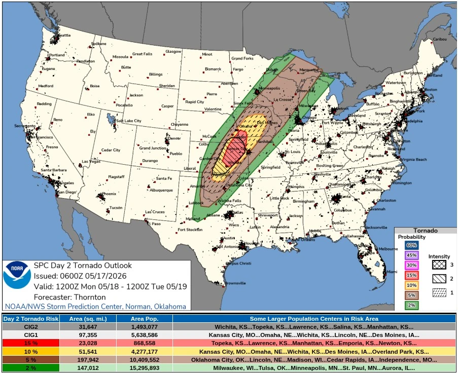
The environment supports an increase in tornado potential through Monday evening. Strong to intense tornadoes are possible primarily from central to northeastern Kansas into southeastern Nebraska if discrete supercells are maintained. Storms near the cold front can also cluster and grow upscale because southwesterly deep-layer shear is oriented somewhat parallel to the southwest-to-northeast front.
The better potential for a more semi-discrete supercell is forecast across central Kansas ahead of the dryline. Some HREF members support this scenario, with long updraft-helicity tracks across Kansas into southern Nebraska. Tornado probabilities were increased from east-central Kansas into southeastern Nebraska and southern Iowa, while the broader enhanced severe corridor extended into northwestern Missouri.
The Monday threat follows an active severe weather setup on Sunday, May 17, when SPC placed parts of the central Plains and mid-Missouri Valley under an Enhanced Risk. The Sunday outlook described severe thunderstorms from the southern and central Plains into the Upper Midwest, with initial supercells capable of very large hail and strong tornadoes before bowing clusters increase the severe and damaging wind threat during the evening.
Farther east on Monday, elevated thunderstorms are forecast at the beginning of the period across portions of Iowa and Wisconsin, with a risk of severe hail. Recovery by Monday afternoon is forecast to allow thunderstorms to redevelop along the cold front, with wind and hail risk extending into Illinois, Indiana, western Kentucky, Wisconsin, and Lower Michigan.
Farther south, SPC identified a more conditional severe risk across Oklahoma and Texas, where large-scale ascent is forecast to remain weaker. Strong instability is still forecast within the moist warm sector, and any storms that develop can produce large to very large hail and perhaps a tornado.
References:
1 SPC Day 1 Convective Outlook – NWS/SPC – May 17, 2026
2 SPC Day 2 Convective Outlook – NWS/SPC – May 17, 2026
I'm a dedicated researcher, journalist, and editor at The Watchers. With over 20 years of experience in the media industry, I specialize in hard science news, focusing on extreme weather, seismic and volcanic activity, space weather, and astronomy, including near-Earth objects and planetary defense strategies. You can reach me at teo /at/ watchers.news.
Commenting rules and guidelines
We value the thoughts and opinions of our readers and welcome healthy discussions on our website. In order to maintain a respectful and positive community, we ask that all commenters follow these rules.