
Storm “Aileen” has officially been named, severe gales expected in central UK
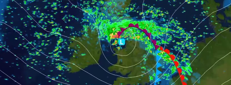
Image credit: Storm "Aileen" forecast track by UK Met Office on September 12, 2017.
The UK Met Office has officially named the first storm of the 2017/18 season on Tuesday, September 12, 2017, as a deepening area of low pressure is expected to cross the UK on Tuesday night into Wednesday morning, September 13, bringing severe gales to central parts of the UK.
Aileen will bring very strong winds across much of England and Wales during Tuesday night and into Wednesday morning. An Amber National Severe Weather Warning is in place, warning of gusts of 88 – 104 km/h (55 – 65 mph) in particular across parts of Cheshire, Lancashire, Derbyshire, Yorkshire, Nottinghamshire, and Lincolnshire. Gusts up to around 120 km/h (75 mph) gusts could also be possible in exposed locations such as the coast and hills in these areas.
Storm Aileen is expected to bring very strong winds with gusts of 80 – 96 km/h (50 – 60 mph) on Tuesday night and into Wednesday morning. The worst of the winds, with gusts to 104 – 120 km/h (65 – 75 mph), are expected to be across North Wales, southern parts of Northern England, the North Midlands and Norfolk, for which area a separate Amber warning is being issued. Longer journey times by road, rail and air are likely, with restrictions on roads and bridges. There is also a chance of power cuts, and damage to trees and perhaps buildings. Along windward-facing coasts, some wave overtopping is possible.
A brief spell of very strong westerly winds with gusts of 104 – 120 km/h (65 – 75 mph) is expected during the early hours of Wednesday. Longer journey times by road, rail and air are looking likely, with restrictions on roads and bridges. Damage to trees and perhaps buildings, as well as power cuts are expected. Flying debris and large coastal waves are possible, and these could lead to injuries.
A Yellow weather warning for rain is also in place for parts of Northern Ireland, Northern England and Southern Scotland which warns of 30 – 40 mm (1.18 – 1.57 inches) of rain falling within 6 – 9 hours which could cause some disruption. The rain may cause flooding on the transport network, with spray and difficult driving conditions due to the combination of rain and wind. There is also a small chance of flooding affecting homes and businesses.
"Storm Aileen is expected to bring strong winds of up to 120 km/h (75 mph) to a central segment of the UK and an Amber weather warning has been issued. As well as the strong winds, there will be some heavy rain pushing eastwards overnight which could see accumulations of 30 – 40 mm (1.18 – 1.57 inches). The low pressure system that is bringing these strong winds will move fairly swiftly from west to east over the UK and although there will still be some disruption through Wednesday morning, the winds will ease by the afternoon leaving a day of blustery showers," Chief forecaster Frank Saunders said.
Road safety spokesperson at Highways England, Richard Leonard, is encouraging drivers to check the latest weather and travel conditions before setting off on journeys, with strong winds expected from Tuesday evening until Wednesday morning. "In high winds, there’s a particular risk to lorries, caravans and motorbikes so we’d advise drivers of these vehicles to slow down and avoid using exposed sections of road if possible."
Although there has been some speculation that this weather is being driven by the severe weather in the Caribbean and US, the Office said there is no such connection.
"There are no links between the very strong winds we expect to see here in the UK and the hurricanes affecting the United States and the Caribbean at present. This system originated well north in the Atlantic Ocean, independent of the current Caribbean hurricanes," Met Office Deputy Meteorologist Chris Tubbs said.
As Storm Aileen clears out eastwards into the North Sea, the UK will be left with cool showery conditions through the end of the week and into the weekend. The showers will still be blustery on Thursday with the winds easing as we get closer to the weekend. Within the showers there will be some periods of brightness although it will still feel cool across the whole of the UK with top temperatures only reaching 18 – 19 °C (64.4 – 66.2 °F).
Find out the current forecast in your area using Met Office's forecast pages.
According to a GFS model run at 06:00 UTC today, after passing over the United Kingdom, Aileen will move toward Denmark into southern Sweeden and then toward Finland, Estonia and Latvia:
GFS forecast model below shows total accumulated precipitation between September 12 and 28, 2017.
Notice prolonged period of very heavy rain over the northern Italy, Slovenia and Croatia. Since the soil in this region is already saturated, this additional rain may cause new rounds of floods, landslides, additional infrastructure destruction as well as waterspouts, some of which may reach land and turn destructive.
I'm a dedicated researcher, journalist, and editor at The Watchers. With over 20 years of experience in the media industry, I specialize in hard science news, focusing on extreme weather, seismic and volcanic activity, space weather, and astronomy, including near-Earth objects and planetary defense strategies. You can reach me at teo /at/ watchers.news.
Commenting rules and guidelines
We value the thoughts and opinions of our readers and welcome healthy discussions on our website. In order to maintain a respectful and positive community, we ask that all commenters follow these rules.