
Increased seismic activity at underwater Lō‘ihi volcano, Hawaii

Image credit: USGS/HVO
Since the end of February 2017, the Hawaii Volcano Observatory (HVO) seismic analysts have noted a slight uptick in the number of earthquakes near underwater Lō‘ihi volcano. The quakes appear to be clustered roughly 10 to 12 km (6 – 7 miles) below sea level and extend from beneath the summit region of Lō‘ihi to the south. The most recent confirmed eruption of this volcano occurred in 1996.
From January 2015 through February 2017, there was, on average, one located Lō‘ihi earthquake per month. Since then, the rate of earthquakes has gradually increased. As of June 22 (the last HVO update on this matter), there have been 51 located earthquakes in the Lō‘ihi region.
"Without permanent seismic stations at Lō‘ihi, because the highest point of the volcano is 1 km (0.62 miles) underwater, it is not possible to locate earthquakes there as accurately as we can at Kīlauea or Mauna Loa," HVO said. "However, we can state that the June 2017 earthquakes appear to be clustered roughly 10 – 12 km (6 – 7 miles) below sea level and extend from beneath the summit region of Lō‘ihi to the south."
Interestingly, the roughly 170 earthquakes located in the area of Lō‘ihi between 2010 and 2016 occurred away from the summit region. They were primarily beneath the northern flanks of Lō‘ihi, and extended to significantly greater depths below the volcano. The significance of this difference is unclear, HVO says.
As early as 1952, HVO scientists interpreted occasional earthquake swarms in the Lō‘ihi region as reflecting active volcanism there. In fact, the earthquakes were key to recognizing that the seamount is actually an active volcano.
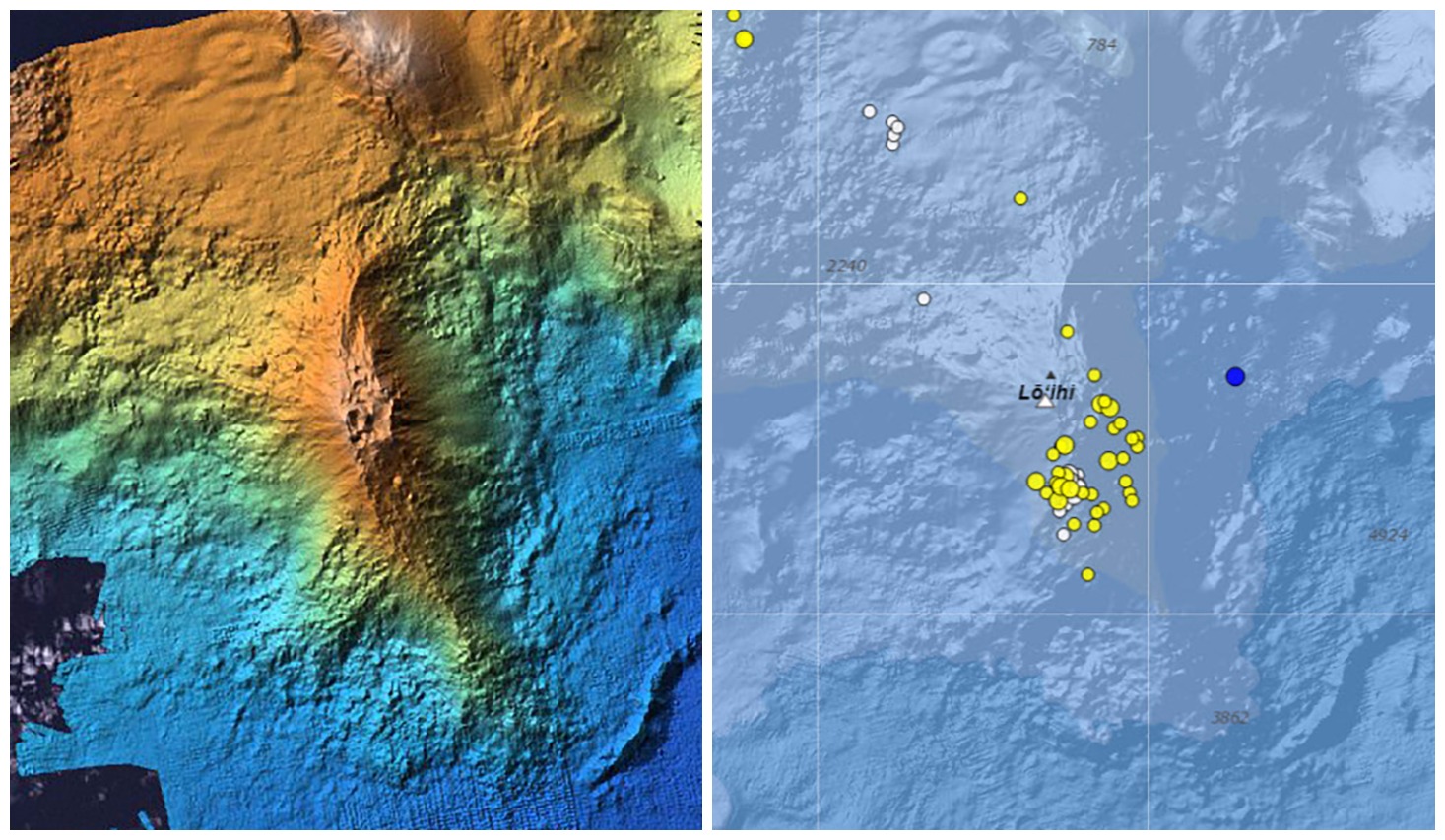
Left: A color-shaded bathymetry map of Lō‘ihi, a submarine volcano located southeast of the Island of Hawai‘i. The summit region is marked by pit craters formed in connection with an eruption and earthquake swarm in July–August 1996. Right: Earthquakes in the vicinity of Lō‘ihi (same area as bathymetry map) located by the USGS Hawaiian Volcano Observatory during a 30-day period ending June 22, 2017. Locations of the earthquakes are shown with dots; size indicates magnitude and color indicates time (blue represents earthquakes within two days of June 22, yellow within two weeks, and white within four weeks). For example, the blue dot east of Lō‘ihi was a magnitude-2.3 earthquake that occurred on June 22. Credit: USGS/HVO
Earthquake activity alone does not conclusively indicate that Lō‘ihi is erupting. But the locations of recent earthquakes directly beneath the volcano's summit region plausibly suggest magmatic or volcanic origin, such as adjustments within the magma reservoir or volcanic edifice. "We would, however, expect to see many more earthquakes associated with an eruption," the observatory notes.
The most recent confirmed eruption of Lō‘ihi occurred in 1996. That year, an energetic earthquake swarm began in July and quickly intensified, motivating a scientific expedition to Lō‘ihi to seize an unprecedented opportunity to possibly observe a submarine eruption. Thousands of earthquakes, including over a dozen with magnitudes greater than 4.5, were recorded from beneath the summit and south flank of the volcano between July and September 1996.
Subsequent viewing and mapping of the Lō‘ihi summit region showed that, consistent with magma movement from beneath the summit area, a significant portion of it had collapsed. Fresh pillow lavas and glassy fragments collected during submersible dives also confirmed the occurrence of an eruption.
"Because Lō‘ihi is still so deep beneath the ocean's surface, the USGS regards Lō‘ihi as a low- to very low-threat volcano. Thus, there are no immediate plans for additional monitoring instruments and our views of Lō‘ihi for the foreseeable future will be strictly seismological," the observatory concluded.
Geological summary
Loihi seamount, the youngest volcano of the Hawaiian chain, lies about 35 km (21.7 miles) off the SE coast of the island of Hawaii. Loihi (which is the Hawaiian word for "long") has an elongated morphology dominated by two curving rift zones extending north and south of the summit. The summit region contains a caldera about 3 x 4 km (1.8 x 2.5 miles9 wide and is dotted with numerous lava cones, the highest of which is about 975 m (3 200 feet) below the sea surface. The summit platform includes two well-defined pit craters, sediment-free glassy lava, and low-temperature hydrothermal venting. An arcuate chain of small cones on the western edge of the summit extends north and south of the pit craters and merges into the crests prominent rift zones.
Deep and shallow seismicity indicate a magmatic plumbing system distinct from that of Kilauea. During 1996 a new pit crater was formed at the summit, and lava flows were erupted. Continued volcanism is expected to eventually build a new island; time estimates for the summit to reach the sea surface range from roughly 10 000 to 100 000 years. (GVP)
I'm a dedicated researcher, journalist, and editor at The Watchers. With over 20 years of experience in the media industry, I specialize in hard science news, focusing on extreme weather, seismic and volcanic activity, space weather, and astronomy, including near-Earth objects and planetary defense strategies. You can reach me at teo /at/ watchers.news.
Commenting rules and guidelines
We value the thoughts and opinions of our readers and welcome healthy discussions on our website. In order to maintain a respectful and positive community, we ask that all commenters follow these rules.