
Major flooding after slow-moving storm hits North Carolina
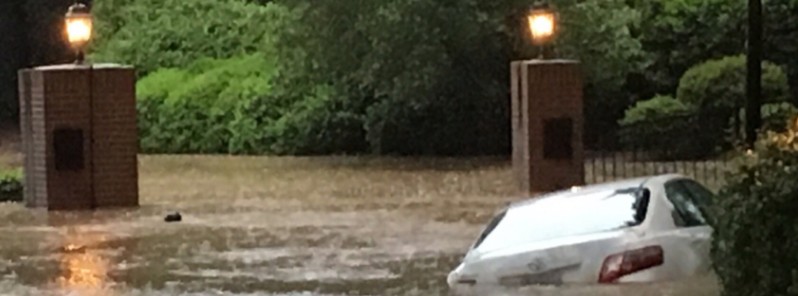
Featured image: Flooding near Anderson Drive in Raleigh, North Carolina on April 25, 2017. Credit: John Astle
After causing major flooding in downtown Charleston, South Carolina, a slow-moving storm caused widespread flash flooding in the Raleigh, North Carolina, metro area early Tuesday, April 25, 2017. On Monday, the rains already flooded numerous roads, caused dozens of crashes and left tens of thousands without power.
A band of heavy rain intensified and focused in parts of central and eastern North Carolina overnight Monday into early Tuesday, after triggering major flooding in downtown Charleston, South Carolina.
With 114.5 mm (4.51 inches), the Raleigh–Durham International Airport set an all-time April record since measurements began in 1887. The previous record was 85.6 mm (3.37 inches). At the same time, a weather station near Falls Lake in Wake county measured 175.3 mm (6.9 inches) of rain in just under 24 hours.
@wxjerdman @CoCoRaHS The 4.51" at KRDU yesterday crushed the April 1-day precip record (previously 3.37") for #Raleigh. Records all the way back to 1887! #ncwx
— Steve Seman (@SteveSeman) April 25, 2017
HEAVY RAIN building back into #Raleigh metro. Localized flooding should ramp up quickly again! pic.twitter.com/rI55Zs7Nw2
— Jim Cantore (@JimCantore) April 25, 2017
745am: Flash Flooding Update. Dangerous conditions in the Triangle this morning. Rain to continue through midday. pic.twitter.com/IuN0jjAOVn
— NWS Raleigh (@NWSRaleigh) April 25, 2017
Right now at Six Forks Rd & Selby Dr near Anderson Drive in #Raleigh #ncwx @breakingweather @TWCBreaking @JimCantore @ReedTimmerAccu @WRAL pic.twitter.com/P0aXzBKzgv
— John Astle (@THEBIGJRA) April 25, 2017
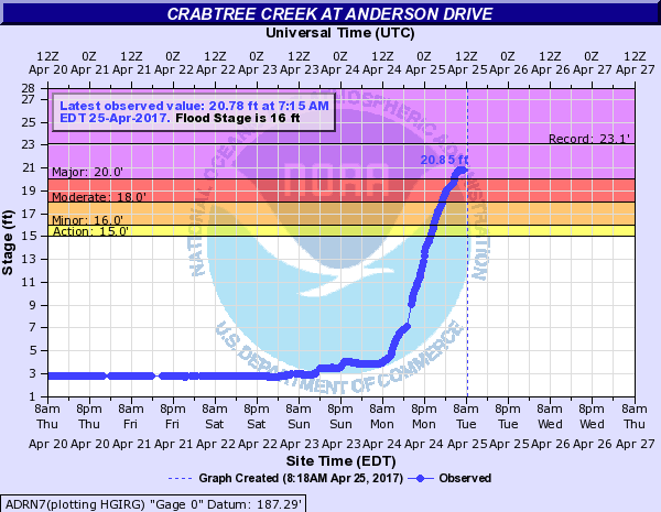
One of the hardest hit areas was Crabtree Creek, north of downtown Raleigh, which rose over 5.18 m (17 feet) since Monday morning, causing flood waters to enter businesses and homes.
It was at 5.84 m (19.17 feet) at 10:30 UTC (06:30 EDT) today, approaching major flood level of 6.09 m (20 feet) and threatening to reach a record crest of 70.4 m (23.1 feet). By 11:15 UTC (07:15 EDT) it was at 6.33 m (20.78 feet).
According to The Weather Channel, flood waters were expected to cover all parking lots at Crabtree Valley Mall, and homes were expected to be flooded along the creek at Anderson Drive. The National Weather Service issued a rare flash flood emergency for Wake County, warning of an "awful" morning commute due to numerous flooded roads.
In Wake County, stretches of Atlantic Avenue, Avent Ferry Road, Highway 42, Capital Boulevard, Wycliff Road, Six Forks Road, and Blue Ridge Road were closed due to flooding. In the city of Wilson, numerous roads were closed, with several cars stalled along Ward Boulevard. One home was flooded on Starship Lane. In Johnston County, southeast of Raleigh, numerous secondary roads were flooded and a water rescue needed on Old Johnson Road.
Before reaching North Carolina, the storm system dumped heavy rain that combined with high tide to trigger significant flooding of multiple streets in downtown Charleston, South Carolina, early Monday morning.
According to the AP, Duke Energy reported more than 2 500 customers without electricity in South Carolina, Monday morning, and more than 59 000 in North Carolina. Some 5 000 customers were still without electricity Tuesday morning, about half of those in and around Raleigh.
Video courtesy Live Storms Media
Video courtesy Live Storms Media
The low pressure area responsible for the flooding will move northward to just south of Long Island New York by Wednesday, the National Weather Service said.
The system will produce showers and thunderstorms over parts of the Southern Mid-Atlantic that will move to coastal Southern New England by Wednesday morning and off the New England Coast by Wednesday evening (local time). The storm will also produce rain over parts of the Northern Mid-Atlantic into parts of the Lower Great Lakes and Southern New England on Tuesday morning that will expand northward into Northern New England by Tuesday evening.
The rain will end over the Lower Great Lakes by Wednesday morning and over the Northern Mid-Atlantic by Wednesday evening, while hanging on over the New England Coast by Wednesday evening.
I'm a dedicated researcher, journalist, and editor at The Watchers. With over 20 years of experience in the media industry, I specialize in hard science news, focusing on extreme weather, seismic and volcanic activity, space weather, and astronomy, including near-Earth objects and planetary defense strategies. You can reach me at teo /at/ watchers.news.
Commenting rules and guidelines
We value the thoughts and opinions of our readers and welcome healthy discussions on our website. In order to maintain a respectful and positive community, we ask that all commenters follow these rules.