
Severe weather warning for stormy conditions across the UK
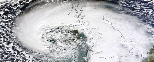
Image credit: NASA Aqua / MODIS
Met Office forecasters have issued a red National Severe Weather Warning for stormy conditions across the UK this afternoon and evening.
The strongest winds are expected across Wales and northern England with gusts of 128 – 160 km/h (80 – 100 mph) in some exposed western areas. Heavy rain will turn to snow over the Pennines and other northern hills and mountains with blizzard conditions for a time.
A red warning from the Met Office means that we need to take action to keep ourselves and others safe from the impacts of the weather. Widespread disruption to travel and other services is likely. All of us should consider changing our plans and avoiding dangerous areas. This kind of warning was not issued for over a year.
Paul Davies, Met Office Chief Meteorologist, said: "The winds through Wednesday afternoon and evening will be damaging and will bring down trees, causing travel disruption and disruption to power networks.
"We advise everyone to stay up to date with Met Office Severe weather warnings and the latest details from our UK forecast during this time of particularly unsettled weather."
Thursday will see generally less windy weather, with some scattered squally showers which could be wintry at times. Another storm will follow on Friday.
Chief Meteorologist Paul Davies explains the red warning issued for wind for the UK and what to do when this warning is issued.

Video courtesy of Met Office UK

Image credit: NASA Aqua / MODIS. Date acquired: February 12, 2014.
Source: Met Office UK

Teo Blašković founded The Watchers in 2011 and edited it until 2026, covering seismic and volcanic activity, extreme weather, space weather and near-Earth objects. Articles on this page are his archive.
Published in the last 24 hours
- A broad low over southeastern Florida and the northwestern Bahamas has a 30 percent chance of subtropical or tropical development within 48 hours and a 50 percent chance within 7 days, the National Hurricane Center says
- High Risk of excessive rainfall covers Florida’s Space Coast as St. Johns River near Cocoa reaches 5.67 m
- Asteroid 2026 WJ to pass Earth at 1.7 lunar distances at 04:20 UTC on November 22, with 2026 WD following at 4.4 lunar distances on November 23
- Cyclone Akvan crossed the north Andhra Pradesh and south Odisha coasts close to Gopalpur on November 20 with 70-80 km/h winds gusting to 90, and has weakened into a deep depression

activist have been approaching politicians …MP's as well as police outside parliament and downing street…..and handing them leaflets regarding geo engineering/chemtrails…..most officials have been sceptical…..that is until now…with this world wide weather mayhem….and some of them have been reading up on the subject….so the black ops organisation behind chemtrails has set up this dissident irish terror threat in order to try to distract officials
https://www.facebook.com/ChemtrailsProjectUK?
ref=ts&fref=ts
http://www.whatintheworldaretheyspraying.info/
http://earth.nullschool.net/
http://www.weatheronline.co.uk/cgi-app/reports?LANG=en&MENU=Extra&FILE=extra_ne&DAY=20130227
http://www.bbc.co.uk/news/uk-england-26171896