
Amber warning in effect as Storm “Abigail” approaches Scotland
Featured image: Storm "Abigail" approaching UK. Image credit: Met Office
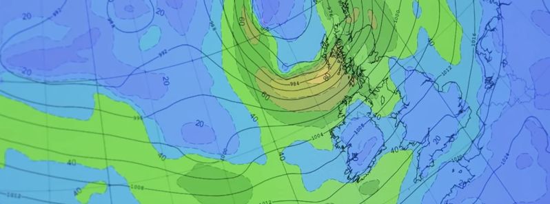
Abigail, the first named storm of the 2015/16 winter season is set to bring strong winds across the northern part of UK over November 12 to 13, according to Met Office announcement.
A deep low pressure system formed a few days ago and was named Abigail on November 10, as a part of the new Met Office and Met Eireann project "Name Our Storms". The project was established as a part of the cooperation between the UK and Irish meteorologists in order to improve the communication of extreme weather events to public, so the citizens will be better informed and capable of keeping themselves safe.
Video credit: Met Office
Storm "Abigail" is expected to bring strong gales across the north and northwest parts of Scotland, including the Western and Northern Isles, as Met Office upgraded the level alert to amber, encouraging the residents to be prepared and take the necessary precaution measures.
Animation showing latest track of #StormAbigail which could bring gusts of 90mph to parts of #Scotland https://t.co/ORVGWYdAhF
— Met Office (@metoffice) November 11, 2015
UK meteorologists forecast severe southwesterly winds with gust speeds between 112.6 and 128.7 km/h (70 and 80 mph), locally even up to 144.8 km/h (90 mph). The low pressure system will be accompanied with lightning and stormy showers. Some disruption to traffic and power supplies is expected across the affected areas. The strong winds will most likely loose its damaging strength by late November 13, according to the current forecast.
"With wind gusts reaching 70-80 mph widely across the warning area with gusts of 90 mph in exposed locations there is the potential for disruption to transport, including ferries and power supplies. The strong winds combined with high tides are likely to cause overtopping of coasts and causeways leading to additional hazards," Paul Gundersen, Chief Operational Meteorologist said.
Video credit: Met Office
Local residents should be prepared and keep an eye on further development over the next 24 hours as the storm approaches UK.
Commenting rules and guidelines
We value the thoughts and opinions of our readers and welcome healthy discussions on our website. In order to maintain a respectful and positive community, we ask that all commenters follow these rules.