
Arctic cyclones more common than previously thought
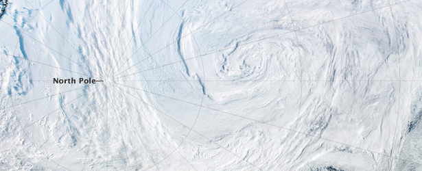
Image credit: TW
Weather data at the Ohio Supercomputer Center reveals in a new study hundreds of smaller storms that had previously escaped detection.
From 2000 to 2010, about 1 900 cyclones churned across the top of the world each year, leaving warm water and air in their wakes – and melting sea ice in the Arctic Ocean.
That's about 40 percent more of these Arctic storms than previously thought, according to a new study of vast troves of weather data that previously were synthesized at the Ohio Supercomputer Center (OSC).
A 40 percent difference in the number of cyclones could be important to anyone who lives north of 55 degrees latitude – the area of the study, which includes the northern reaches of Canada, Scandinavia and Russia, along with the state of Alaska.
The finding is also important to researchers who want to get a clear picture of current weather patterns, and a better understanding of potential climate change in the future, explained David Bromwich, Ph.D., professor of geography at The Ohio State University and senior research scientist at the Byrd Polar Research Center.
The cyclone study was presented at the American Geophysical Union meeting in December, in a poster co-authored by his colleagues Natalia Tilinina and Sergey Gulev of the Russian Academy of Sciences and Moscow State University.
"We now know there were more cyclones than previously thought, simply because we've gotten better at detecting them," said Bromwich, who amassed the weather database and consulted on the cyclone study.
Cyclones are zones of low atmospheric pressure that have wind circulating around them. They can form over land or water, and go by different names depending on their size and where they are located. In Columbus, Ohio, for instance, a low-pressure system in December would simply be called a winter storm. Extreme low-pressure systems formed in the tropical waters can be called hurricanes or typhoons.
How could anyone miss a storm as big as a cyclone? You might think they are easy to detect, but as it turns out, many of the cyclones that were missed were small in size and short in duration, or occurred in unpopulated areas. Yet researchers need to know about all the storms that have occurred if they are to get a complete picture of storm trends in the region.
"We can't yet tell if the number of cyclones is increasing or decreasing, because that would take a multi-decade view. We do know that, since 2000, there have been a lot of rapid changes in the Arctic – Greenland ice melting, tundra thawing – so we can say that we're capturing a good view of what's happening in the Arctic during the current time of rapid changes," Bromwich said.
Bromwich leads the Arctic System Reanalysis (ASR) collaboration, which uses statistics and computer algorithms to combine and re-examine diverse sources of historical weather information, such as satellite imagery, weather balloons, buoys and weather stations on the ground. ASR provides researchers with high-resolution information against which researchers can validate climate prediction tools.
"There is actually so much information, it's hard to know what to do with it all. Each piece of data tells a different part of the story – temperature, air pressure, wind – and we try to take all of these data and blend them together in a coherent way," Bromwich said.
To generate the complex visualizations, the ASR group accessed thousands of cores on OSC's HP-Intel Xeon "Oakley Cluster" and IBM 1350 Opteron "Glenn Cluster" over the last few years to run the complex Polar Weather Research and Forecasting model (Polar WRF). Polar WRF was created by the Polar Meteorology Group of the Byrd Polar Research Center at Ohio State and is a modification of the Weather Research and Forecasting model widely used by researchers and most federal agencies.
The ASR group analyzed 17 surface variables, 71 forecast surface variables, 13 forecast upper air variables and 3 soil variables. The data accumulated for and generated by the model filled hundreds of terabytes of disk space on the center's IBM Mass Storage System. The combined data are made publicly available to scientists.
Two such scientists are cyclone experts Tilinina and Gulev, who worked with Bromwich to look for evidence of telltale changes in wind direction and air pressure in the ASR data. They compared the results to three other data re-analysis groups, all of which combine global weather data.
"We found that ASR provides a new vision of the cyclone activity in high latitudes, showing that the Arctic is much more densely populated with cyclones than was suggested by the global re-analyses," Tilinina said.
One global data set used for comparison was ERA-Interim, which is generated by the European Centre for Medium-Range Weather Forecasts. Focusing on ERA-Interim data for latitudes north of 55 degrees, Tilinina and Gulev identified more than 1,200 cyclones per year between 2000 and 2010. For the same time period, ASR data yielded more than 1,900 cyclones per year.
When they narrowed their search to cyclones that occurred directly over the Arctic Ocean, they found more than 200 per year in ERA-Interim, and a little more than 300 per year in ASR.
There was good agreement between all the data sets when it came to big cyclones, the researchers found, but the Arctic-centered ASR appeared to catch smaller, shorter-lived cyclones that escaped detection in the larger, global data sets. The ASR data also provided more detail on the biggest cyclones, capturing the very beginning of the storms earlier and tracking their decay longer.
Extreme Arctic cyclones are of special concern to climate scientists because they melt sea ice, Bromwich said.
"When a cyclone goes over water, it mixes the water up. In the tropical latitudes, surface water is warm, and hurricanes churn cold water from the deep up to the surface. In the Arctic, it's the exact opposite: there's warmer water below, and the cyclone churns that warm water up to the surface, so the ice melts."
As an example, he cited the especially large cyclone that hit the Arctic in August 2012, which scientists believe played a significant role in the record retreat of sea ice that year.
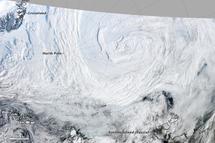
An unusually large, long-lasting, and powerful cyclone was churning over the Arctic in early August 2012. Two smaller systems merged on August 5 to form the storm, which at the time occupied much of the Beaufort-Chukchi Sea and Canadian Basin. On average, Arctic cyclones last about 40 hours; as of August 9, 2012, this storm had lasted more than five days.
The Visible Infrared Imaging Radiometer Suite (VIIRS) on Suomi NPP captured this view of the storm on August 7, 2012. The Moderate Resolution Imaging Spectroradiometer (MODIS) aboard Aqua captured a natural-color image of the storm as well.
Arctic cyclones are more common during the summer than winter; however, summer cyclones tend to be weaker than the storms that batter the region during the winter. This cyclone’s central sea level pressure reached about 964 millibars on August 6, 2012—a number more typical of a winter cyclone. That pressure puts it within the lowest 3 percent of all minimum daily sea level pressures recorded north of 70 degrees latitude, noted Stephen Vavrus, an atmospheric scientist based at the University of Wisconsin.
The number of cyclones affecting the Arctic appears to be increasing. According to a study of long-term Arctic cyclone trends authored by a team led by John Walsh and Xiangdong Zhang of the University of Alaska Fairbanks, the number and intensity of Arctic cyclones has increased during the second half of the twentieth century, particularly during the summer. (Read more on this cyclone here) Image credit: NASA / Earth Observatory (Aqua / MODIS)
I'm a dedicated researcher, journalist, and editor at The Watchers. With over 20 years of experience in the media industry, I specialize in hard science news, focusing on extreme weather, seismic and volcanic activity, space weather, and astronomy, including near-Earth objects and planetary defense strategies. You can reach me at teo /at/ watchers.news.
"about 1 900 cyclones" Typo?