
Arctic sea ice sees drastic recovery, reaches largest early February ice extent in 11 years

Image credit: Jorma Hevonkoski
The arctic sea ice has reached its largest early February ice extent in 11 years, surpassing the average size from 2001 to 2010. The recovery is a result of a strong polar vortex.
Sea ice analysis indicated that during this rather mild winter in the middle latitudes, trapped colder air in the polar circle had a positive impact on the rapid growth and recovery of the polar ice cap, Severe Weather Europe meteorologists said. The Arctic ocean freezes during winter, reaching a maximum sea ice extent around March.
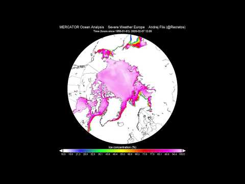
In two animations produced by SWE, the rapid growth of ice cap can be observed, as well as the ice getting thicker over time.

SWE also noted that an analysis from the National Snow and Ice Data Center (NSIDC) "shows the sea ice area and extent compared to the long term average."
"In most places, the extent is not far behind the long term averages. The greatest individual deficit is in the Sea of Okhotsk."


Images courtesy NSIDC
SWE remarked that the ice cap is "in pretty good shape" at a concentration in finer resolution. Although the concentrations on the outer edges were lower than usual, it is still a very good concentration image compared to the previous years.
Most of the thinner ice is the fresh ones that formed this winter, and most of it will melt in the summer.
"Speaking of previous years, when comparing to past years, we can see that there has not been such a large ice extent at least since 2010," SWE said, adding that a lot of it has something to do with beneficial weather conditions this winter.
"Thanks to the strong polar vortex, the Arctic sea ice reaches the largest ice extent in the past 11 years."
Also, in the last 20 years, 2020 is at the seventh-largest ice extent for early February. "It is just above the average extent of the 2001-2010 period."

Published in the last 24 hours
- The storms drenching California this week are fed by a river in the sky, a band of water vapor that can carry up to 15 times the flow of the Mississippi River, and this winter’s near-record El Niño could keep aiming more of them at the West Coast
- Malawi continues Bris AI weather forecasting tests ahead of operational integration Epicenter
- Right about now, Voyager 1 is crossing a line no human-made object has ever reached, a full light-day from Earth, which means a message NASA sends tonight won't arrive until tomorrow night, and the spacecraft's answer won't make it home until the night after that
- G1 geomagnetic storm watch remains in effect as NOAA forecasts Kp 4.67 late on November 17 and early on November 18

Compare the 12-month average artic sea ice size standardized deviations January 1953 – October 2018 at https://nsidc.org/cryosphere/sotc/sea_ice.html and the height profile of the magnetic north in Google Earth made with the coordinates of https: // http://www.ngdc.noaa.gov/geomag/data/poles/pole_locations.txt
both curves follow each other