
Severe, damaging and shallow earthquake M 6.6 struck Cook Strait, New Zealand again – Hundreds of aftershocks
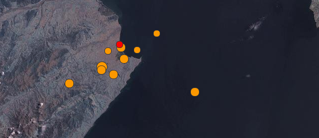
Image credit: USGS/Leaflet
A swarm of strong and shallow earthquakes is shaking Cook Strait, New Zealand again. After M 6.5 that struck on July 21, 2013, and hundreds of aftershocks that followed, another severe, damaging and shallow earthquake M 6.6 hit on August 16, 2013 at 02:31 UTC. Damage has been reported on both sides of Cook Strait. The earthquake sequence is generating hundreds of aftershocks, although most of them are not felt.
Epicenter was located 29 km (18 miles) SSE of Blenheim and 80 km (50 miles) SW of Wellington, New Zealand. There are about 427 156 people living within 100 km radius.
USGS measured depth at 10 km, EMSC at 2 km and GEONET at 8 km.
GEONET explains "The focal mechanism shows it to be a strike-slip earthquake, similar to the M6.5 earthquake in July. We have now had two similarly-sized earthquakes with the same sort of characteristics – they are termed a "doublet". This is not what we would usually expect."
Strike-slip faults are vertical (or nearly vertical) fractures where the blocks have mostly moved horizontally. If the block opposite an observer looking across the fault moves to the right, the slip style is termed right lateral; if the block moves to the left, the motion is termed left lateral.
GEONET prognosis says there will be an aftershock sequence to follow this earthquake, and we already have had several over magnitude 5. The revised forecast for a further magnitude 6 or greater, for the next 24 hours from 5:30 pm 16 August, is 28%. See the updated the statistics table.
South of Blenheim, towards Seddon, roads are partially blocked by rockfalls and are cracked in some areas. The NZ stock exchange stopped trading briefly. About 600 customers were reportedly without power in Makara, Wrights Hill and Wainuiomata following the quake. One building south of Seddon nearly collapsed by the mainshock. Some others in Marlborough region were also severly damaged, while the damage on North Island (Wellington region) is only minor. Two minor injuries were reported.
Many people fear a "big one" is coming.
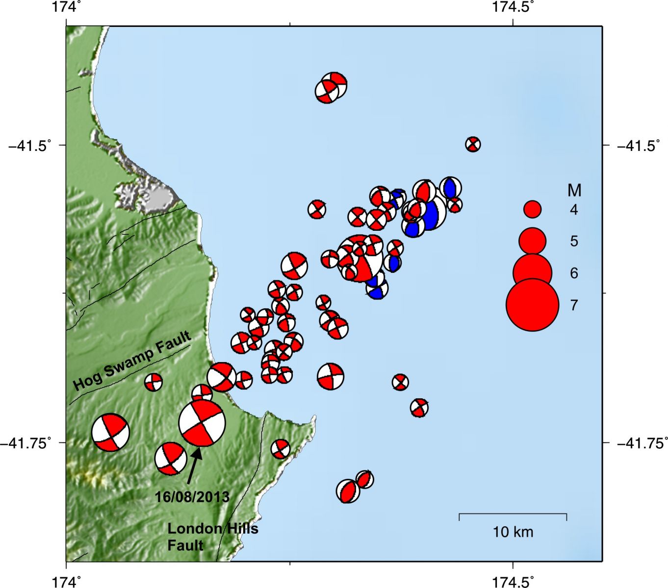
Today's quake has a strike-slip mechanism.
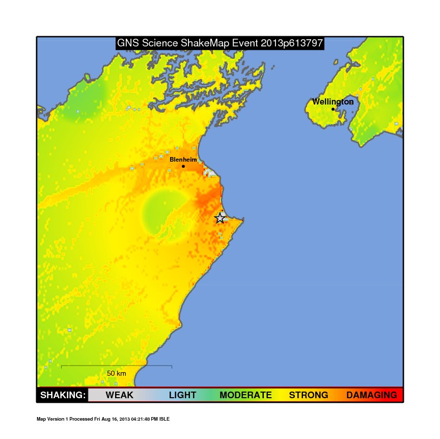
The "ShakeMap" showing the shaking intensity as determined by GeoNet instruments and modelled against ground conditions.
Tectonic summary by USGS
The M 6.5 August 16, 2013 earthquake south of Blenheim, New Zealand, occurred as the result of strike-slip faulting on or near the plate boundary between the Pacific and Australia plates. At the latitude of this event, the Pacific plate moves towards the WSW with respect to Australia at a rate of approximately 41 mm/yr. Preliminary faulting mechanisms for the earthquake suggest it is related to either NE-SW right-lateral strike-slip motion (consistent with plate boundary oriented deformation), or NW-SE left-lateral strike-slip motion.
This region of New Zealand has hosted a number of small-moderate sized earthquakes in recent weeks, including a M 6.5 earthquake approximately 40 km east of the August 16 event in the Cook Straight, on July 21, 2013. The July 21 event was preceded by several M 5.3-5.8 events and was followed by a dozen or more aftershocks between M 4.5-5.0, delineating shallow upper plate structures aligned NE-SW, and some deeper subduction-related activity, mostly offshore of the north coast of New Zealand’s South Island.
In contrast to the earlier events, the August 16 earthquake is on land, near the eastern end of the complex Marlborough Fault System. The event is located approximately 10 km southeast of the Awatere Fault in the vicinity of Lake Grassmere. The Marlborough Fault system is characterized by a series of NE striking right-lateral strike slip faults that have dismembered the northern South Island into a series of crustal blocks that are being transported to the northeast. Although there is no specific mapped surface fault that can be linked to the August 16 event at this time, the NE trending fault plane is similarly oriented to the Awatere and Clarence faults of the Marlborough system. In 1966 a M 5.8 earthquake (interpreted to have occurred offshore to the NE of the August 16 event) was widely felt in this area, causing surface deformation of the main railroad line in the region. That event is interpreted to have occurred on a blind structure sub-parallel to the Awatere fault to its northeast.

Seismotectonics of the Eastern Margin of the Australia Plate
The eastern margin of the Australia plate is one of the most sesimically active areas of the world due to high rates of convergence between the Australia and Pacific plates. In the region of New Zealand, the 3000 km long Australia-Pacific plate boundary extends from south of Macquarie Island to the southern Kermadec Island chain. It includes an oceanic transform (the Macquarie Ridge), two oppositely verging subduction zones (Puysegur and Hikurangi), and a transpressive continental transform, the Alpine Fault through South Island, New Zealand.
Since 1900 there have been 15 M7.5+ earthquakes recorded near New Zealand. Nine of these, and the four largest, occurred along or near the Macquarie Ridge, including the 1989 M8.2 event on the ridge itself, and the 2004 M8.1 event 200 km to the west of the plate boundary, reflecting intraplate deformation. The largest recorded earthquake in New Zealand itself was the 1931 M7.8 Hawke's Bay earthquake, which killed 256 people. The last M7.5+ earthquake along the Alpine Fault was 170 years ago; studies of the faults' strain accumulation suggest that similar events are likely to occur again.
North of New Zealand, the Australia-Pacific boundary stretches east of Tonga and Fiji to 250 km south of Samoa. For 2,200 km the trench is approximately linear, and includes two segments where old (>120 Myr) Pacific oceanic lithosphere rapidly subducts westward (Kermadec and Tonga). At the northern end of the Tonga trench, the boundary curves sharply westward and changes along a 700 km-long segment from trench-normal subduction, to oblique subduction, to a left lateral transform-like structure.
Australia-Pacific convergence rates increase northward from 60 mm/yr at the southern Kermadec trench to 90 mm/yr at the northern Tonga trench; however, significant back arc extension (or equivalently, slab rollback) causes the consumption rate of subducting Pacific lithosphere to be much faster. The spreading rate in the Havre trough, west of the Kermadec trench, increases northward from 8 to 20 mm/yr. The southern tip of this spreading center is propagating into the North Island of New Zealand, rifting it apart. In the southern Lau Basin, west of the Tonga trench, the spreading rate increases northward from 60 to 90 mm/yr, and in the northern Lau Basin, multiple spreading centers result in an extension rate as high as 160 mm/yr. The overall subduction velocity of the Pacific plate is the vector sum of Australia-Pacific velocity and back arc spreading velocity: thus it increases northward along the Kermadec trench from 70 to 100 mm/yr, and along the Tonga trench from 150 to 240 mm/yr.
The Kermadec-Tonga subduction zone generates many large earthquakes on the interface between the descending Pacific and overriding Australia plates, within the two plates themselves and, less frequently, near the outer rise of the Pacific plate east of the trench. Since 1900, 40 M7.5+ earthquakes have been recorded, mostly north of 30°S. However, it is unclear whether any of the few historic M8+ events that have occurred close to the plate boundary were underthrusting events on the plate interface, or were intraplate earthquakes. On September 29, 2009, one of the largest normal fault (outer rise) earthquakes ever recorded (M8.1) occurred south of Samoa, 40 km east of the Tonga trench, generating a tsunami that killed at least 180 people.
Across the North Fiji Basin and to the west of the Vanuatu Islands, the Australia plate again subducts eastwards beneath the Pacific, at the North New Hebrides trench. At the southern end of this trench, east of the Loyalty Islands, the plate boundary curves east into an oceanic transform-like structure analogous to the one north of Tonga.
Australia-Pacific convergence rates increase northward from 80 to 90 mm/yr along the North New Hebrides trench, but the Australia plate consumption rate is increased by extension in the back arc and in the North Fiji Basin. Back arc spreading occurs at a rate of 50 mm/yr along most of the subduction zone, except near ~15°S, where the D'Entrecasteaux ridge intersects the trench and causes localized compression of 50 mm/yr in the back arc. Therefore, the Australia plate subduction velocity ranges from 120 mm/yr at the southern end of the North New Hebrides trench, to 40 mm/yr at the D'Entrecasteaux ridge-trench intersection, to 170 mm/yr at the northern end of the trench.
Large earthquakes are common along the North New Hebrides trench and have mechanisms associated with subduction tectonics, though occasional strike slip earthquakes occur near the subduction of the D'Entrecasteaux ridge. Within the subduction zone 34 M7.5+ earthquakes have been recorded since 1900. On October 7, 2009, a large interplate thrust fault earthquake (M7.6) in the northern North New Hebrides subduction zone was followed 15 minutes later by an even larger interplate event (M7.8) 60 km to the north. It is likely that the first event triggered the second of the so-called earthquake "doublet". More information on regional seismicity and tectonics
How many Cook Strait earthquakes so far?
The following video shows Cook Strait earthquakes recorded from July 19 – August 3, 2013:
Numbers of Cook Strait region earthquakes since 7 am, 19 July 2013 | |
| Magnitude range | Number |
|---|---|
| 6.0 – 6.9 | 2 |
| 5.0 – 5.9 | 13 |
| 4.0 – 4.9 | 88 |
| 3.0 – 3.9 | 472 |
| 2.0 – 2.9 | 2067 |
| TOTAL | 2642 |
| This table was last updated on 16 August 2013 PM. Source: GEONET | |
Ten largest earthquakes so far
Cook Strait earthquakes, science update
New Zealand: where two tectonic plates collide
I'm a dedicated researcher, journalist, and editor at The Watchers. With over 20 years of experience in the media industry, I specialize in hard science news, focusing on extreme weather, seismic and volcanic activity, space weather, and astronomy, including near-Earth objects and planetary defense strategies. You can reach me at teo /at/ watchers.news.
Thanks for a very succinct and informative article. I will post a link to this from the Weatherzone – General Science – Earthquakes forum, to offer us all there an article full of great info, on our sister/brother country's EQ issues.
Cheers from Oz.