
Deep earthquake M 6.0 struck Celebes Sea, Philippines
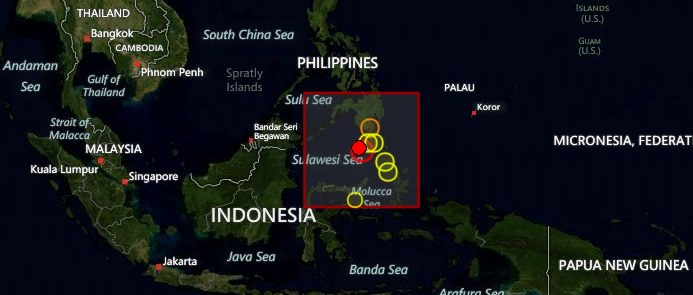
Image credit: TW
Deep earthquake with recorded magnitude of 6.0 struck Celebes Sea, Philippines on October 17, 2012 at 04:42 UTC according to USGS. Epicenter was located 166 km (103 miles) SW of Sarangani, Philippines at coordinates 4.191°N, 124.573°E. Recorded depth by USGS was 337.4 km (209.7 miles). EMSC reported this earthquake as magnitude 6.1 and with depth of 342 km.
GDACS said that this earthquake can have a low humanitarian impact based on the magnitude and the affected population and their vulnerability. There are no people living within 100 km.
| Magnitude | 6.0 |
|---|---|
| Date-Time |
|
| Location | 4.191°N, 124.573°E |
| Depth | 337.4 km (209.7 miles) |
| Region | CELEBES SEA |
| Distances | 166 km (103 miles) SW of Sarangani, Philippines 193 km (119 miles) SSW of Glan, Philippines 199 km (123 miles) S of Kiamba, Philippines 212 km (131 miles) SSW of Malapatan, Philippines |
| Location Uncertainty | horizontal +/- 12.4 km (7.7 miles); depth +/- 5.7 km (3.5 miles) |
| Parameters | NST=266, Nph=283, Dmin=337.3 km, Rmss=1.17 sec, Gp= 22°, M-type=regional moment magnitude (Mw), Version=9 |
| Source |
|
| Event ID | usb000d7a8 |
USGS location map

I'm a dedicated researcher, journalist, and editor at The Watchers. With over 20 years of experience in the media industry, I specialize in hard science news, focusing on extreme weather, seismic and volcanic activity, space weather, and astronomy, including near-Earth objects and planetary defense strategies. You can reach me at teo /at/ watchers.news.
This blog is excellent, thank you for posting the latest on earth change. We both have similar websites on the subject of earth changes. Leave a comment on our web blog for link back mate :-)!