
Magnitude 4.7 earthquake recorded just 25 km off the Fukushima nuclear plant
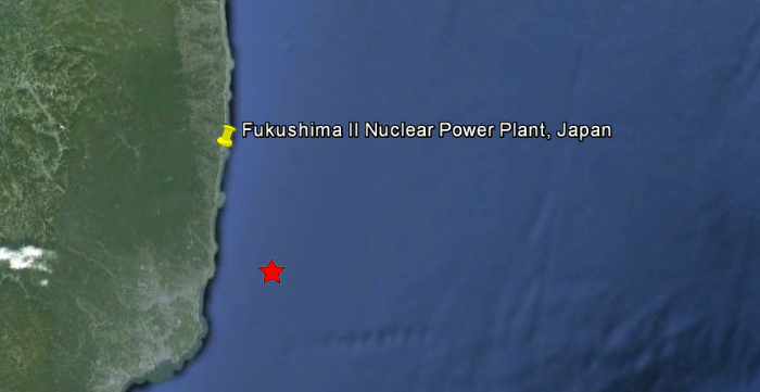
Image credit: Google Earth + USGS
4.7 magnitude earthquake just 25 km (15 miles) off the Fukushima nuclear plant was recorded on Sunday, April 15, 2012 at 10:36 UTC (19:36 JST). Epicenter was 23 km (14 miles) ENE of Iwaki, Honshu, Japan (37.103°N, 141.142°E).
USGS recorded depth of 30.7 km (19.1 miles). Japan Meteorological Agency (JMA) is also reporting 4.7 magnitude earthquake but with depth of 10km.
This is strongest earthquake recorded close to Fukushima nuclear plant today. A swarm of earthquakes was reported for the region yesterday.
Read more: The greatest single threat to humanity – Fukushima nuclear reactor no. 4 raises new global worries
The following is a list of all earthquakes reported by JMA for April 14 and part of April 15, 2012 (Updated: 12:06 UTC on April 15).
| Issued at | Occurred at | Region Name | Magnitude | Maximum seismic intensity (JMA Seismic Intensity) |
|---|---|---|---|---|
| 19:42 JST 15 Apr 2012 | 19:36 JST 15 Apr 2012 | Fukushima-ken Oki | M4.7 | 2 |
| 13:50 JST 15 Apr 2012 | 13:45 JST 15 Apr 2012 | Tokushima-ken Hokubu | M3.4 | 2 |
| 13:38 JST 15 Apr 2012 | 13:33 JST 15 Apr 2012 | Miyagi-ken Oki | M3.1 | 1 |
| 08:22 JST 15 Apr 2012 | 08:18 JST 15 Apr 2012 | Ibaraki-ken Oki | M3.6 | 1 |
| 05:46 JST 15 Apr 2012 | 05:41 JST 15 Apr 2012 | Ibaraki-ken Oki | M4.0 | 2 |
| 03:01 JST 15 Apr 2012 | 02:57 JST 15 Apr 2012 | Tochigi-ken Hokubu | M2.0 | 1 |
| 02:30 JST 15 Apr 2012 | 02:26 JST 15 Apr 2012 | Fukushima-ken Oki | M3.5 | 1 |
| 01:01 JST 15 Apr 2012 | 00:56 JST 15 Apr 2012 | Chiba-ken Toho-oki | M3.7 | 1 |
| 00:12 JST 15 Apr 2012 | 00:08 JST 15 Apr 2012 | Fukushima-ken Oki | M4.4 | 2 |
| 00:08 JST 15 Apr 2012 | 00:05 JST 15 Apr 2012 | Fukushima-ken Oki | M4.4 | 2 |
| 23:18 JST 14 Apr 2012 | 23:13 JST 14 Apr 2012 | Fukushima-ken Oki | M4.0 | 1 |
| 23:10 JST 14 Apr 2012 | 23:05 JST 14 Apr 2012 | Miyagi-ken Oki | M2.6 | 1 |
| 22:58 JST 14 Apr 2012 | 22:53 JST 14 Apr 2012 | Ibaraki-ken Oki | M3.8 | 1 |
| 22:22 JST 14 Apr 2012 | 22:17 JST 14 Apr 2012 | Fukushima-ken Oki | M4.3 | 1 |
| 21:44 JST 14 Apr 2012 | 21:40 JST 14 Apr 2012 | Tokara-retto Kinkai | M4.7 | 3 |
| 20:12 JST 14 Apr 2012 | 20:08 JST 14 Apr 2012 | Iwate-ken Oki | M4.2 | 2 |
| 20:04 JST 14 Apr 2012 | 20:00 JST 14 Apr 2012 | Ibaraki-ken Oki | M3.6 | 1 |
| 19:56 JST 14 Apr 2012 | 19:51 JST 14 Apr 2012 | Fukushima-ken Oki | M4.6 | 2 |
| 19:52 JST 14 Apr 2012 | 19:48 JST 14 Apr 2012 | Fukushima-ken Oki | M4.5 | 2 |
| 19:01 JST 14 Apr 2012 | 18:57 JST 14 Apr 2012 | Fukushima-ken Oki | M3.9 | 1 |
| 18:30 JST 14 Apr 2012 | 18:25 JST 14 Apr 2012 | Ibaraki-ken Oki | M5.0 | 3 |
| 18:10 JST 14 Apr 2012 | 18:06 JST 14 Apr 2012 | Ibaraki-ken Oki | M3.9 | 1 |
| 17:50 JST 14 Apr 2012 | 17:46 JST 14 Apr 2012 | Fukushima-ken Oki | M4.3 | 3 |
| 11:38 JST 14 Apr 2012 | 11:33 JST 14 Apr 2012 | Ibaraki-ken Hokubu | M3.3 | 1 |
| 11:15 JST 14 Apr 2012 | 11:10 JST 14 Apr 2012 | Chiba-ken Toho-oki | M3.9 | 1 |
| 10:16 JST 14 Apr 2012 | 10:11 JST 14 Apr 2012 | Iwate-ken Oki | M4.3 | 2 |
| 07:58 JST 14 Apr 2012 | 07:54 JST 14 Apr 2012 | Chiba-ken Toho-oki | M3.6 | 2 |
| 04:42 JST 14 Apr 2012 | 04:37 JST 14 Apr 2012 | Hokkaido Hokusei-oki | M2.6 | 1 |
| 04:03 JST 14 Apr 2012 | 04:00 JST 14 Apr 2012 | Ibaraki-ken Oki | M3.9 | 3 |
| 03:29 JST 14 Apr 2012 | 03:25 JST 14 Apr 2012 | Miyagi-ken Oki | M4.4 | 2 |
| 01:56 JST 14 Apr 2012 | 01:52 JST 14 Apr 2012 | Fukushima-ken Oki | M4.3 | 2 |
| 01:01 JST 14 Apr 2012 | 00:57 JST 14 Apr 2012 | Fukushima-ken Oki | M4.1 | 1 |
| 00:59 JST 14 Apr 2012 | 00:55 JST 14 Apr 2012 | Sanriku Oki | M4.8 | 1 |
| 00:30 JST 14 Apr 2012 | 00:26 JST 14 Apr 2012 | Fukushima-ken Oki | M4.4 | 2 |
| 00:01 JST 14 Apr 2012 | 23:56 JST 13 Apr 2012 | Miyagi-ken Oki | M3.3 | 1 |
Details of April 15, 2012, 4.7 magnitude earthquake
| Magnitude | 4.7 |
|---|---|
| Date-Time |
|
| Location | 37.103°N, 141.142°E |
| Depth | 30.7 km (19.1 miles) |
| Region | NEAR THE EAST COAST OF HONSHU, JAPAN |
| Distances | 23 km (14 miles) ENE of Iwaki, Honshu, Japan 75 km (46 miles) ESE of Koriyama, Honshu, Japan 94 km (58 miles) SE of Fukushima, Honshu, Japan 200 km (124 miles) NE of TOKYO, Japan |
| Location Uncertainty | horizontal +/- 19.8 km (12.3 miles); depth +/- 6.6 km (4.1 miles) |
| Parameters | NST=172, Nph=172, Dmin=269.4 km, Rmss=0.69 sec, Gp=104°, M-type=body wave magnitude (Mb), Version=7 |
| Source |
|
| Event ID | usc000944l |
![]()
I'm a dedicated researcher, journalist, and editor at The Watchers. With over 20 years of experience in the media industry, I specialize in hard science news, focusing on extreme weather, seismic and volcanic activity, space weather, and astronomy, including near-Earth objects and planetary defense strategies. You can reach me at teo /at/ watchers.news.
Four earthquakes registering at 6.1, 6.0, 5.2, & 5.0 in Canada’s NW Territory were removed from ANF or Array Network Facility between the hours of 19:39 & 19:46 on Saturday April 14th. Why they were moved I do not know, but they were large enough to be recorded by the ANF.
I do have screen shots (posted by others) of the events as they occurred.
http://anf.ucsd.edu/
Send us the screenshots or post below pls.